 |
 |
 |
 |
 |
 |
 |
|
|
July 2000. From the snowy mountains to the sandy beach (2000)
After getting experiences on five cycletours in Slovakia and two in Austria and Slovenia in july 2000 I was ready to bike on my most serious tour in my life: to push the pedals from my favourite area, the Dolomites - which is said to be one of the worlds most beaufiful mountain-ranges reaching the Adriatic sea to Nagykanizsa, a hungarian town next to the border. As in last year this year I also travelled to Cavalese, the place of our holiday with my parents, from where I set out the 1400km long with a 3 day long detour homeway after a week long training, warming up and programs together with my parents. In every case I wanted to visit the wonderful Lake Garda which I only heard about and Venice that I liked from the videos, but where I also hadnt been before. During the week I spent in the Dolomites with my parents I made three beautiful cycletours and managed to cycle through some passes.
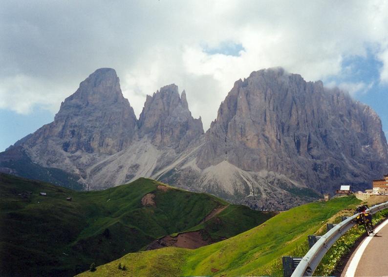
1st training tour: After the gently sloping 43km in a nice and steep valley I had to go through a 11 km long 7% steep ascent up to the 2240m high Sellapass. 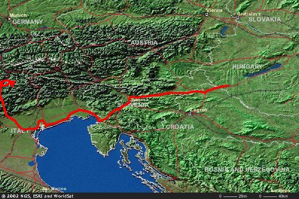 The name of this pass can be usually heard in connection with the Giro dItalia. From Canazei where the steep climb starts the road is one of the most beautiful passroads of the Dolomites. The ascent was going through a friendly forest, then through meadows with flowers next to high steep rockwalls. I met with a lot of bikers. The beauty of the land fascinated me: cycling with my on power and go up to the pass was much other than arrive there by a car. In the last 5-6 km I could read the names of the famous competitors of the Giro on tha asphalt: Pantani, Gotti, Tonkow. The picture of the 3181m high Sassolungo with its triple top was wonderful.
Towards St Ullrich the road twisted in the side of the mountain, then in the valley I could roll down faster because of the little number of bends. On the sunny and wide pasture of the Seiser Alm I climbed up on 12-14% steep ascent onto the 1437m high Pinei pass. From Kastelruth I tried to ascend up on a 8%,
The name of this pass can be usually heard in connection with the Giro dItalia. From Canazei where the steep climb starts the road is one of the most beautiful passroads of the Dolomites. The ascent was going through a friendly forest, then through meadows with flowers next to high steep rockwalls. I met with a lot of bikers. The beauty of the land fascinated me: cycling with my on power and go up to the pass was much other than arrive there by a car. In the last 5-6 km I could read the names of the famous competitors of the Giro on tha asphalt: Pantani, Gotti, Tonkow. The picture of the 3181m high Sassolungo with its triple top was wonderful.
Towards St Ullrich the road twisted in the side of the mountain, then in the valley I could roll down faster because of the little number of bends. On the sunny and wide pasture of the Seiser Alm I climbed up on 12-14% steep ascent onto the 1437m high Pinei pass. From Kastelruth I tried to ascend up on a 8%,
 but sometimes 10% steep road to the plateau of the Seiser Alm, which steepness I was informed from the diagram of the website www.salite.ch It seemed to be difficult. It took me one hour to climb up to the 1844m high Seeiser Alm going through a pleasant fir tree forest for a long. I was tired after the climb so I needed some energy from foods. After 30-35 km freewheeling I arrived at Bolzano. From the descent there was beautiful view back to the rockwall of Schlern which had nice orange colours an hour before the sunset. Although homewards I only had to pass through the 1100m high St Lugan pass, because its 900m heightdifference and the way how it was going on the side of the mountain it was a great experience. This pass is not between the famous passes, but its unforgettable for me that the road goes in the side of the vertical rockwall for 2-3 km long. Riding on the outer edge - althouh there was a barrier - it wasnt a good feeling to look at down into the deepness. At the end of my tour I managed to climb the pass a little bit tired in one and a half hour, and I reached the saddle in dusk. After a short rolling I arrived at home. (175 km + 3396 m heightdifference)
2nd training tour: I visited two not so high and not so known passes, but after them I could say, one of them, the Rolle pass would be one of my favourite. The 12 km long and 6,4% steep ascent to the Passo San Pellegrino started in Moena, after half an hour cycling.
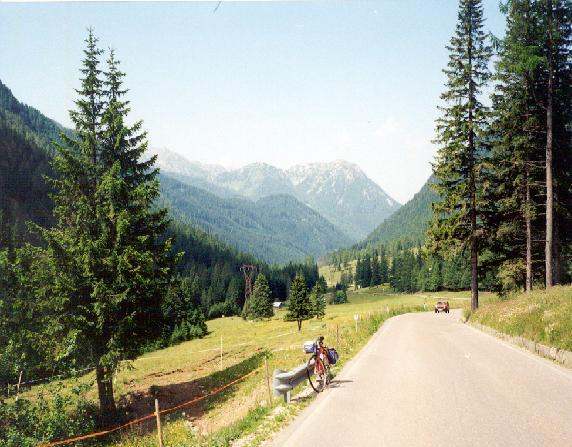 The land gave my the mood of the slovakian Tatra because of the flowery fields and fir tree forests in the valley. The steepness was serious only in short sections. From the village, Falcade which is on the eastern and steeper side of the pass there was a very scenic view to the columnrocks of the more than 3000m high Cimon de Pala. The 33km long connecting road between Agordo and the foot of the next climb was going in a thin but deep valley. I enjoyed the stream and the nature between the steep rockwalls. Not only a passroad but a valley can be nice too. On the climb of the 1369m high Cereda-pass I could take pleasure in the picture of the mountains which character was other than the mountains before. These mountains were a little bit southern type for me. Pushing the pedals the deciduous forests were changed for fir tree forests. More and more dark clouds were arriving to and staying above the rocks of the Pale di San Martino. After rolling down from the pass to the 750m high situated Fiera di Primiero the 22 km long ascent of the 1970m high Rolle pass waited for me. In some sites (for example tour reports in the site, Trento Bike Pages or some sentences and photos of the site, Virtual Alps) Id read that this climb would be not too steep, but continuous and monotonous. It was true on the halfway to San Martino di Castrozza, because there was not too much view out from the forest. But if there was, that would be fantastic view to the high rockwalls of the Pale di San Martino, but unfortunately there were clouds around it. I had to be afraid of some rain, but I didnt have other opportunity, than climbing and than rolling down home. In the holiday-resort San Martino di Castrozza there were a lot of beautiful and some luxurious - hotels, restaurants, shops with nice lights. It seemed to be a nice village. The second part of the passroad was more interesting than the first, because of the less forests, more views and the nearness of the summit. The mountainside was pleasant; I also enjoyed the hainpin-bends. Fortunately the rain started to fall not too much time after when I was already cycling in the last almost flat kilometer. After I hurried under the eaves of a house I realised how the clouds were coming lower and lower until the time when I could see only the first 150m of the rocks. With the voices of the thunders it was a little bit frightening to be so close to the mountains, not too far from the fog and not too much time before the sunset and there were always thundering. I couldnt wait for long because the darkness. During the rolling down in the rain when it wasnt raining so serious, than before - I had cold; I had to shake my legs and arms and make them tremble not to feel the cold. In the last 20 kms I could bike on dry roads. Homewards I could take delight of some clouds lighted by the sunset. It was wonderful after a nice day. (183 km + 3671m heightdifference)
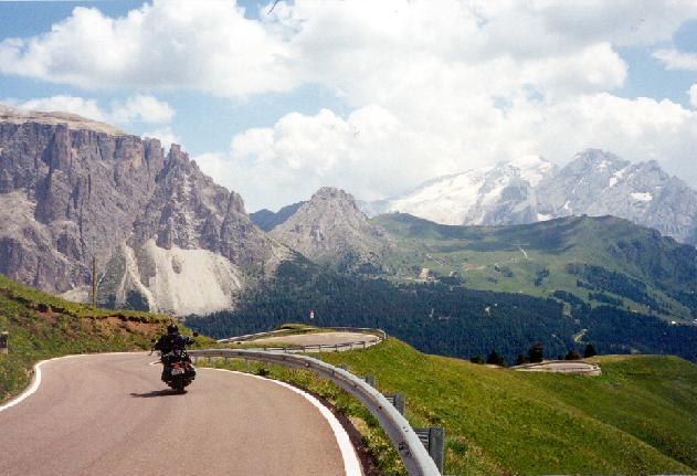
3rd training tour: On my last - serious - tour without any heavy pack I liked to climb up four passes: the Fedaia (2056m), the Giau (2236m), the Falzarego (2105m) and homewards the Pordoi (2239m). The 14 km long and continuous 6% steep climb to the Fedaia pass was going in the first part in fir tree forest,
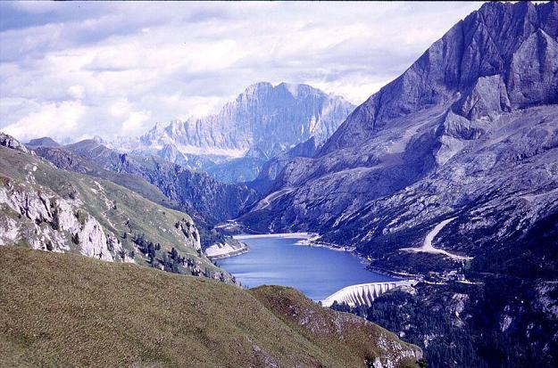 then it was directed into some tunnels with windows on it in its right side. There were only columns in that side, so I could enjoy the scenic view of the 3342m high Marmolada and its glaciers. At the summit I found the ca. 2 km long clear lake I had known already and straight ahead the Civetta showed its rocks. Backwards there was also a nice picture of the Rosengarten group. It is a wonderful rockgroup in the Dolomites and is famous for its colours in the sunset. The descent is sometimes on the program of the Giro dItalia, because upwards sometimes its 16% steep. In spite of the long straight slope I didnt have enough braveness to fast above the speed of 70 km/h. From Caprile (1014m) I biked up to the 1453m high Colle Santa Lucia on a wonderful road. The scenic view on the left started from the Lake Alleghe and the 2000m higher Civetta (photo) (with its 1500m high rockwall) then in the middle the area and the valley of the Fedaia pass with the Marmolada and at the end, on the right the valley towards to the Pordoi-pass. The little village, Caprile was nearly 500 m deeper than me.
 I was behind the schedule of my plan, so after the beautiful experiences of the morning I decided not to hurry and tire me out with cycling on the 8-10% steep ascent of the Giau pass, but to choose the only 1773m high Staulanza pass and then homewards the Pordoi pass. The climb up to the Staulanza pass was not a difficult one, it sloped gently towards the huge rocks of the Monte Pelmo which was a surprise for me. From the Santa Lucia pass I already saw this mountain, and I was sad to miss the road towards it, because I believed (without looking at the map) that the road under it is the Giau-pass. So pushing the pedals towards this beautiful mountain was a nice surprise. The pass was just next to the Monte Pelmo. The last serious effort of my tour was the 10 km long ascent of the 2239m high Pordoi pass. The heightdifference was 639m, so it seemed to be a middle steep climb. I managed to bike up on this twisting road in the lights of the sunset. The tables with the height in every bend helped me a lot. The ascent was continuously same steep and it gave a lot of pictures to Arabba and the valley behind it. I met only a few cars and cyclists because of the early-evening. From the saddle I could see the triple top of the Sassolungo lighted by the last lights of the sun. I arrived home in dark again. (195 km + 3410 m heightdifference)
1st day: Cavalese Bolzano Merano Reschenpass Nauders (A) = 119 km + 1342 m heightdifference
After a cold front I started my 11 day long cycletour with a 24kg pack to the hungarian Nagykanizsa in a 23 degree warm, sunny and clear weather. I said goodbye to my parents in Bolzano. While they left for home my destination was Nauders, the next day starting departure of the Dreilander Radgiro bicyclemarathon. Nearly every bikers arrived there by car, but I had to cycle 90 kms from the 120 km in facewind and push the pedals on a climb for hours. Because of my bikepacks the wind could slow me more than without them. From Merano the ascent was various; generaly flat and middle steep climbs changed each other. The day with its long and gently sloping road and at its end with the 1504m high Reschenpass wouldnt have been a light one, but with the wind together it made me tired. Because of the wind it was just like I had to cycle on a middle steep climb for hours. It was with a 24 kg pack and a day before the bicyclemarathon. On the flat stages I rarely could cycle faster than 18 km/h. I needed my last energy to go up to the Reschen pass (Passo Resia). At the summit I had to take raincoat and raintrousers. The competitors who were waiting for the registration saw me with a surprise, because they arrived there in warm cars with having a rest. Because of the strong efforts and the cold weather (on a paper of the tourist office I read that next they the temperature on the Stilfser Joch would be only about 5 degrees centigrade) I changed my registration for the longer distance to the shorter B distance. I had been waiting for climbing up to the Stilfser Joch for months but I had to decide that, because I didnt want to get cold and not to arrive home by bike. After the marathon I had to cycle a lot of kilometers. In the tourist office the officers were friendly: because the cold weather they welcome the bikers with brandy. In my hotelroom that I had reserved from Hungary I fell asleep with a little bit of excitement.
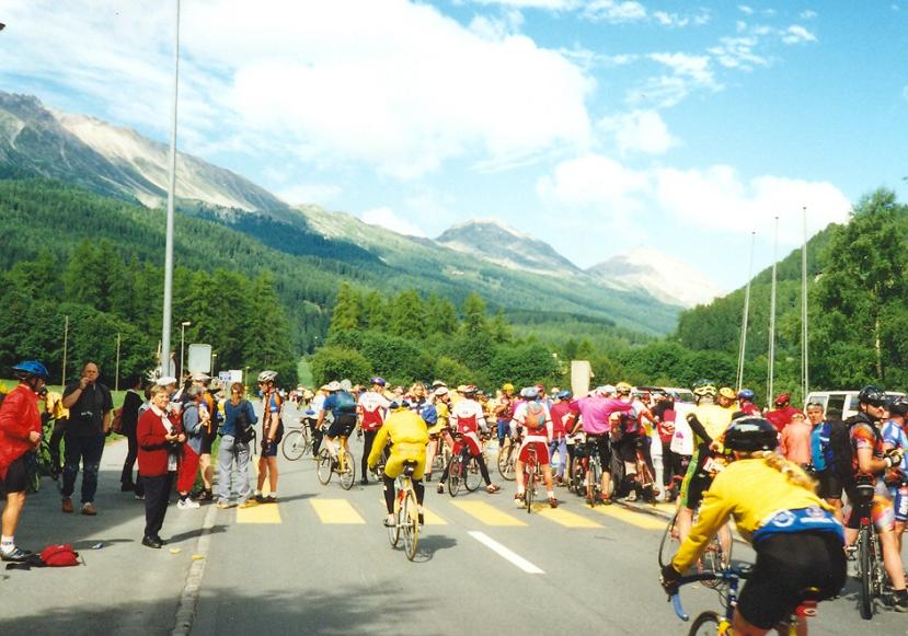
2nd day: Dreiländer Radgiro Bicyclemarathon = 136 km + 2020 m heightdifference
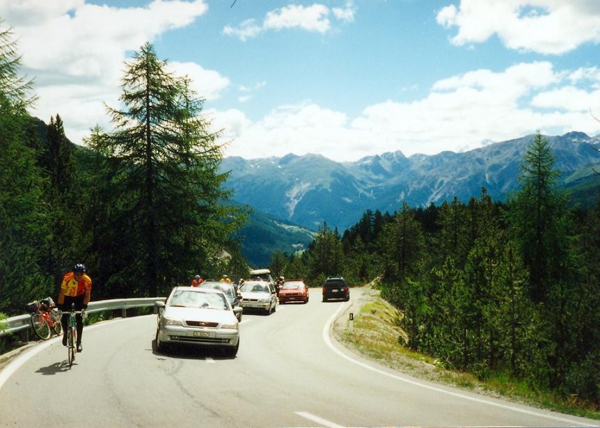
While the competitors who chose the longer distance started in the early morning I and the other competitors who chose the shorter distance started at 8.30 am after a salute of guns and voices of trumpets. We were about 300. We were cycling up on the gently sloping ascent of the Reschenpass under middle clouds and somewhere blue sky. On our 136 km we had to climb the 1504m high Reschenpass, then the 2149m high Ofenpass and at last the 1471m high Norbertshöhe.
I took some warm clothes and tools in the small bag before the handle-bars. After the start I was going to the first half of the peloton with a good speed. On the plateau and on the descent I couldnt go so fast like the racebikres because of my touringbike and I didnt want to hurry. At nice places I stopped to make photos. Next to a nice lake after the summit we get a view to the mountains around the Stilfser passroad. There was snowy above about the height of 2000m. It should had been snowing in the night. From Glurns we had to turn towards Switzerland and the 2149m high Ofenpass. Between the cyclists everybody could find the other bikers who were pushing the pedals with the same pace.
In Sta. Maria the bikers from the two distances came together; the guys and girls from the A distance had already gone through the 2760m high Passo dello Stelvio. At the freshing point there were a lot of cyclists. I enjoyed very much when some of them took a banana or drink from the hands of the organizors without stopping. I took delight of the view of the mountains towards the Ofenpass. In the first part I could overtake some competitors with a good gear, but on the section with its 8-10% steepness I had to change gears and because of the big difference between them I was cycing with the others with 12 km/h. On the 10% steep descent of the pass I flew down in warm clothes, but there were some bikers who overtook me; maybe they knew the road. Between Zernez where we got drinks and some food and the austrian border we could push the pedals on a light descent. In the first part I could bike with the 35-40 km/h speed of others, but than I preferred to bike with my own pace. From the last freshing point, Martina we had only 6 km climb. The great number of the bikers made me cycle with a good speed; I overtook a lot of them which I enjoyed very much because they had a light bike, but mine was about 14 kg weight. Thats true that I think most of them had the passroad up to The Passo Stelvio in their legs. In the finish, Nauders there were barriers on the sides of the road. It was a good feeling that some of the local inhabitants welcome each cyclist with applause. After I got the jersey and other souvenirs I spent the afternoon with having a rest and with watching the Wimbledon tennis final, which was won by my favourite, Pete Sampras. I sadly hear on TV that next day a cold and rainy weather would come, so I changed my mind about my programs. It wasnt worth cycling to between the high mountains in a rainy and cold weather. In spite of that I decided to hurry cycling away from the mountains towards the warmer area of the Lake Garda. (I arrived at the finish about at the two thirds of the peoloton B.)
3rd day: Nauders (A) Mals (I) Merano Bolzano Leifers = 126 km + 200 m heightdifference
Murphy had right again I thought when I was cycling up to the Passo Resia facing against a serious wind. Two days ago in the opposite direction I also had facewind. The weather was not on my side, because on this day I also needed efforts to cycle against the wind. I had to push the pedals on light descents too. In Merano with its southern mood I spent only one hour because the clouds were more and more closer to me. The rain caught me some kilometers after Bolzano, in Leifers. In the camping of the village I could build up my tent in time.
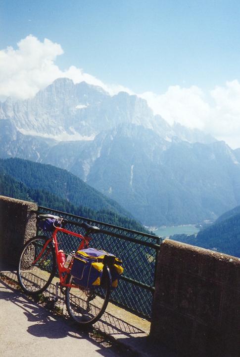
4th day: Leifers Trento Riva del Garda = 93 km + 302 m heightdifference
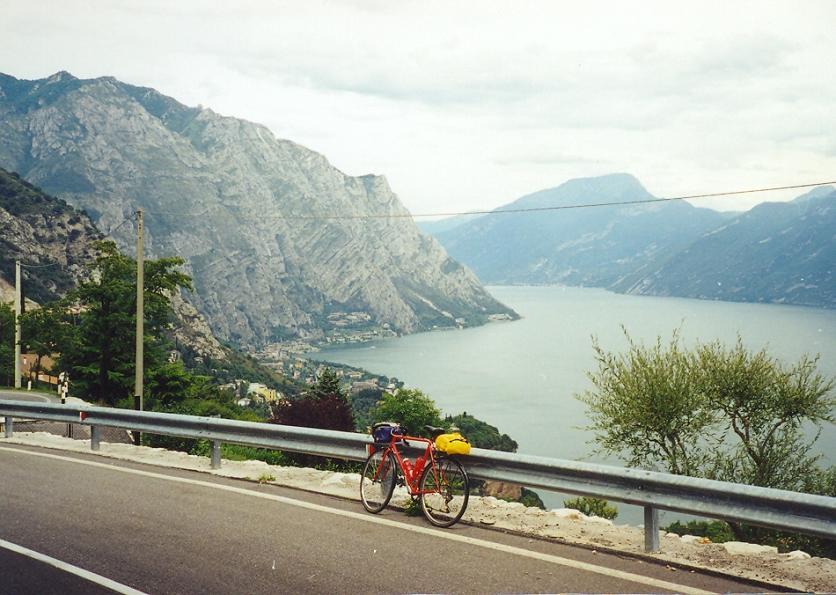
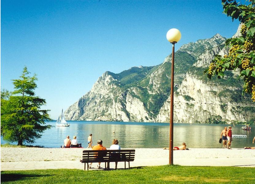
30 minutes after that the 20 hour long rain had finished the sun was already shining. The air was humid, but pleasantly warm; it was fine to cycle in such a weather, and between such mountains, in such valley. The sky became blue, the picture to the mountains were more beautiful with a few little clouds in front of them. From Trento I had to climb 3-4 kms up and then rolling down for example next to the castle of Toblino to arrive into the valley of the Lake Garda. This part of the Alps has other character than in the area of the bicyclemarathon. Here the mountains are more rocky and steeper, and in the valleys there are palmtrees, nice flowers and evergreens. Walking on the shore of the Lake in front of the camping Bavaria I was looking around to the mountains very happy: I could arrive here by bike. (Some years ago my parents spent some days there and then I got mood to go there, but by bike.)
5th day: Local tours at the Lake Garda = 121 km + 550 m heightdifference
Based on my plans schedule I liked to cycle on both side of the Lake without the big pack.
In the morning I was biking on the east side of the Lake to Casteletto di Brenzone and back. At that time the sun was shining the western mountains very well. In the wonderful clear weather I enjoyed the fantastic land and nature very much. The beautiful rocky mountains, roads in amazing places, coloured boats on the clear water, sailing ships and surfing people on the lakes, and nice flowers, palm trees and castles gave the mood of the Lake Garda.
What az experience it was! In the afternoon I was cycling mainly in tunnels to Limone on the western shore of the Lake, where from I biked on a 12-15% steep road onto the sides of the western mountains. I met with very friendly villages there, about which I saw photos on the Internet. Thay made me cycle there and it was a very good idea. I had some very scenic view down to the Lake. An interesting experience was to cycle through tunnels on the side of the rocks and to hear the horns of the cars, because in the tunnels there was place for only one car at the same time. I found his road on the descent between Pieve and the shore of the Lake. It was a fantastic day.
6th day: Riva del Garda Rovereto Vicenza - Padova Mestre = 160 km + 1273 m heightdifference
I left the Lake Garda on a trafficked road towards Rovereto. I couldnt enjoy the ascent because of the huge numbers of the cars. I said goodbye to the lake with a nice photo. From Rovereto I chose the long passroad to the 162m high Passo pian delle Fugazze towards Vicenza. 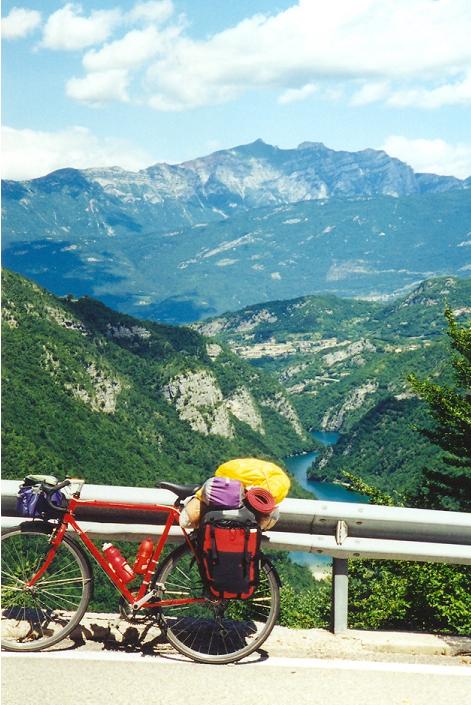 Cycling between 2000m high mountains and looking at two turquoise lakes I found a little trafficked wonderful road. The 27 km long climb started with some steep sections but there were nice views to the mountains, to the valley, and to the lakes. The section in the middle was almost flat, here I could gather some energy for the last steep section. On the steep and twisting descent I had to be careful. On this slope I arrived at the plane; there wasnt any mountains in front of me. In spite of a puncture I had before Schio and it took time to change the tyre, during cycling towards Vicenza I was thinking about what to do, where to try to sleep. At last I decided to spend my night not next to Padova, but more closer to Venice, maybe next to Mestre. In Vicenza I found very nice the the graceful Renaissance buildings, palaces. This town is said to be a favourite town of those people who like the art of architecture. I left the next town, Padova about the time of the sunset. The lamps were lighting in the romantic villages situated on the shore of the channel close to the sea. Cycling next to the channels had a pleasant atmosphere; tourists were walking it the centers of the villages, I hear musicvoice from the restaurants; it was tipical evening-life. Unfortunately the road was busy. I arrived at the first camping that was shown by a table a little before 22 pm.
7. day: Mestre Treviso Lido di Jesolo Cavallino = 97 km + 30 m heightdifference
Although the next camping where I wanted to spent my night was on the peninsula of Jesolo only 60kms away, I thought I had time to visit Treviso on a detour. The town had totally other character than Vicenza. In Treviso most of the buildings were built using red or brown bricks. I spent one hour in this atmospheric town with a nice park then I tried to cycle fast away from there because of the light rain. On the road of the Cavallino peninsula I had to bike very carefully because of the huge numbers of the cars and some lorries. The road was thin, the row of the cars was long; it wasnt a surprise that after when a lorry had overtaken me I felt relief a little bit. I think they also wasnt happy to meet a cyclist with a wide pack on that road. After building up my tent I walked to the Adria beach. I couldnt see any people to bath or swim in the sea, because of the weather. The people were walking or playing in the sand in long armed clothes along the beach. Some of them flyed a kite.
8th day: Venice (without bike)
With a combined ticket I travelled to Venice by bus and then by a ship. Because the clouds flew away I had a clear weather again (like at the Lake Garda; I had fortune again.) After landing (from the ship) at first I didnt know where to go. I could hardly believe that I arrived at Venice with my own energy.
I enjoyed the atmosphere of the town very much; I liked it more than the beauty of the buildings. I took pleasure in the vaporettos on the channel, the lot of tourists, the musicians, the pigeons. I sailed around the famous town by a vaporetto, I admired the houses, palaces of Canale Grande, then I stepped a lot in the thin streets and at the shore of the channels. In the afternoon I had rest with hearing the music of a jazz music group on a small square.
9th day: Cavallino Latisana Monfalcoe Trieszt Senozece = 171 km + 875 m heightdifference
After I left the Alps, the Lake Garda and Venice, when I was cycling on a flat and monotonious area I felt more and more homesickness. After Latisana I caught a pair of french cyclists also with packs. For a time they were cycling with my pace behind me, then we started to speak with each other in English. I felt proud because of the fact that I was cycling from the Dolomites towards my home throught a litte bit cycling in Switzerland, then I asked them: -Where do you cycle from, what is the destination ? The french pair was on the tour of their lives: with bicycle from Paris through a few passes of the Alps, along the Adria to Greece. I envied them. I hoped that we could say goodbye to the dark clouds that were going after us, but we turned to the south in vain, we couldnt left them. The clouds went with us to Triest. We rolled down into the town from a mountain ridge, so from there up we could admire the wide sea, and the town and the unbelievable picture how the dark cloud changed to the sky or white clouds. I think I hadnt seen such wide and dark cloud(s) before. We hurried into a café before the rainfalling. We wished a good journey and weather for each other when we said goodbye. While they went on along the Adriatic sea, I planned to sleep in Slovenia, towards Postojna.
10th day: Senozece Postojna Ljubljana Litija Celje Atomske teplice = 202 km + 650 m heightdiff.
To arrive next day in time (17 pm.) at the railway station of Nagykanizsa for this day I planned to cycle almost through the whole country of Slovenia: about 200kms. In the area of Postojna I biked on ascents and descents under blue sky and through green fir tree forests. The beauty of the land make me remember to Slovakia, although the quality of the roads wasnt so good. After Logatec I had to cycle for some kilometer on a road built by concrete-planes. It was so bumpy that I had to push the pedals slower: I was very angry about it! In Ljubljana when I could I was biking on the main roads, althugh there were a lot of cycleroads in the town, but I wanted to hurry. In the city I chose the bikeroads. Ljubljana was a pleasant experience with its city, pedestrianized streets, the nice, friendly streams through the center, with some parks and small bridges in the centre too. I was cycling towards Litija, although the fact, that in the first fewkilometers I could see one or two tables that cycling is forbidden there. I dont know why, because it was not too trafficked road and it had a very good surface in a nice valley with small mountains, along the river Sava. I had backwind so I left the kilometers behind me with a good speed. Zagorje and Hrastnik were industrial towns, but Lasko famous about its beer-factory was a wonderful and friendly one. A lot of houses were decorated and there were a lot of flowers, and desks and chairs in the center; the town were nearly ready for the beer-festival. On the last section between Celje (a nice castle here) and the camping of Atomske Teplice I was riding the bike a little bit tired.
11th day: Atomské Teplice Rogatec - Lepoglava Varazdin Nagykanizsa = 170 km + 450 m heightdifference
Unfortunately for my last day I got cloudy and rainy weather, so after the day when I lost my raincoat this day seemed to be not a good one for me. After leaving the camping I was cycling to the croatian border on a hilly area. In Croatia between Podgora and Lepoglava when it started to rain and then for a half kilometer the road surface was gravel I would be very angry. After then I hurried towards Lepoglava because of the rain. Riding out under the clouds from Varazdin I could cycle on dry roads, but the time I lost because of the rain I had not too much time for having a rest. With a minimum stopping I was biking with 26 km/h towards the railway station of Nagykanizsa. In Hungary I often looked at my watch and counted the kilometers I had yet. I arrived at the station quarter hour before the start of my train. It was enough! I arrived at the finish.
Aggregated data and practical informations:
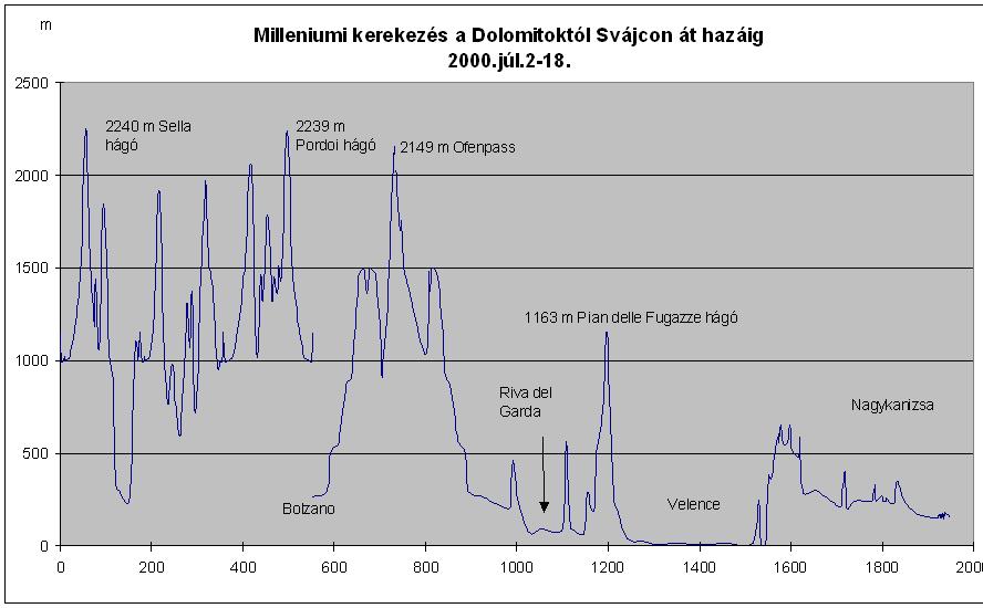
- During 3 + 11 days 1948 km + 18169 m heightdifference
- Costs (for 11 days with the costs of the bicycle marathon): ca. 80000 HUF
The prices of the campings where I spent nights was between 20000 and 30000 Lire (Cavallino).
In some places in Italy there were cycleroads next to te main road; and there were good bicycleroads for example in Vicenza, Padova. On the Cavallino peninsula (Jesolo, etc.) the prices of the campings are - I think - about one and a half times higher of the campings in Leifers or at the Lake Garda (prices in www.camping.it.
Györgyi Gábor