Linkek


Szerzői jogok!

Hágóim bemutatása
(1994-2004)
MAGYAR ÉS KÜLFÖLDI BRINGÁS LINKEK azok tartalmával együtt


|
 ORGANIZER:
Gabor Györgyi (314); e-mail: gyorgabi at externet.hu
and Gábor Kreicsi (415); e-mail: gabor.kreicsi at nograd.b-m.hu
PROGRAM OF THE RENDEZVOUS:
- 30- June - 0. day, Friday: Arrival to Budapest and then to travel to Salgótarján
if it fits into that day, we can cycle up to Dobogókő (35 kms from Budapest) and back
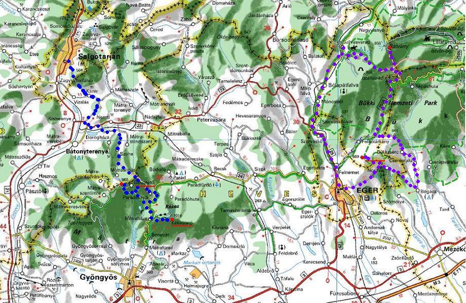
- 1. July - 1st day, Saturday: 1st tour (Bánkút, Várhegy): by car(s) to Szilvásvárad, then
 By car to Szilvásvárad (organised by Gábor Kreicsi) - from there : Szilvásvárad (310 m) - Bánkút ski-house (ca. 23 km) - Bánya hegy (junction) - Ódorvölgyi junction (ca. 56 km) - Bükkzsérc - Noszvaj (ca. 81 km)- ) Várhegy (86 km) - Eger (104 km) - Szilvásvárad = 132 km + 1300-1400 m heightdiff.
As we can whoose 3 different route to visit the two BIGs, we can decide which we like the most. The above mentioned is one of them.
SHORT VERSION:
by car to Szilvárvárad, then by bicycle: Szilvásvárad - Bánkút - Szilvásvárad = ca. 46 km (then maybe walk in the Szalajka valley / waterfall !
-2. July - 2nd day: Sunday, 2nd tour (Galyatető, Kékestető) : Salgótarján - Nemti - Szuha - Galyatető(ca. 41 km) - Kékestető (59 km) - Parádsasvár (75 km) - Szuha - Salgótarján = 113 km + 1300 - 1500 m heightdiff.
SHORT VERSION:
Salgótarján - Galyatető - Salgótarján (ca 82 km + 800 m heightdiff.)
or Salgótarján - <>KÉkestető - Salgótarján = 108 km + 900 m heightdiff.
and then TRAVEL BACK (TO BUDAPEST AND....)
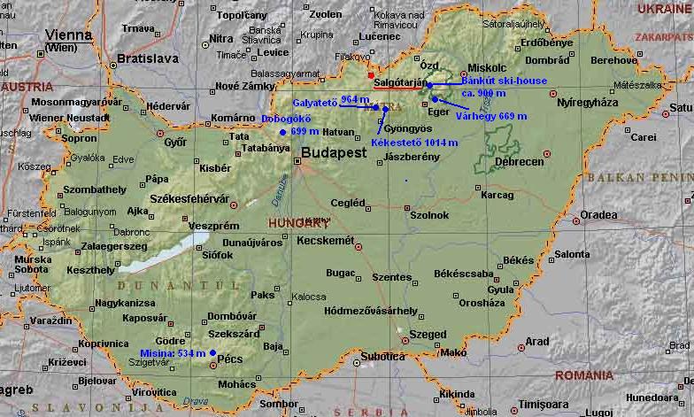
EXTRA: If the participants want it, I can show them the fifth BIG - not far from Budapst -, the 699m high Dobogókő, which is almost a "house-mountain" for me, as I live 23 kms from it, and I often visit it.
ACCOMODATION:
In Salgótarján in motels (during organizing);
as planned: BAZALT PANSION
: price: ca. 12-20 EUR / head
or MEDVES HOTEL: price: for 2 nights with 2 breakfast and 2 supper : 54 EUR
| WE NEED THE FOLLOWING INFORMATIONS, DATA FROM THE PARTICIPANTS: |
| Name |
| e-mail and (before arriving) mobile number |
| Date and place (Budapest or Salgóarján) of arrival |
| Date of departure back to home |
Which mode of travel between Budapest and Salgótarján :
need for help in travelling - Gabor can help by car if there is need for it. |
| Which tours are preferred ? |
| Do you ask as for organising acccomodation or not ? |
Thanks: Gabor(s)
The map of the 2 day long BIG - rendezvous:
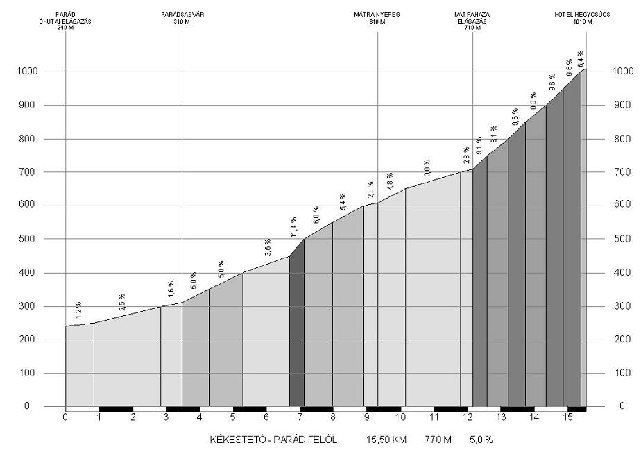
KÉKESTETŐ 1015 M:
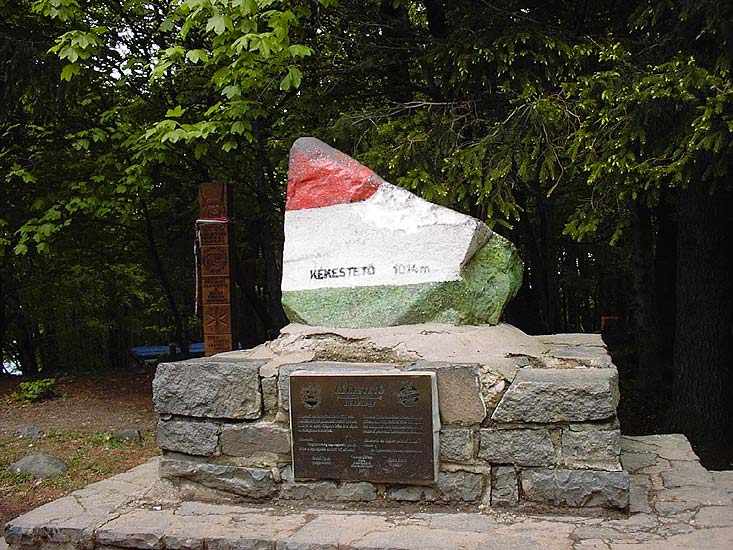
 Pics about Kékestető (1015 m)
The highest point of HUngary is situated in the heart of the Matra mountain range. From north the road - hrough the forest - twists ad turns up towards the peak starting next to Parádsasvár.
The road goes in a leafy forrest. At the ca. 680 m high situated Mátraháza we had to turn left for a steep road, on which we had to struggle 3,5 kms up to the peak. The road is more times 10% steep, and it had long stretches, where backwards we can enjoy downhilling above the steep of 80 km/h.
Between the houses of Kékestető we had to push the pedals, until when there is asphalt on the road. Before the TV tower we had to climb another 50 m long gravel section to reach the stone of the peak, which is painted for red, white and green colours: the colors of the national flag.
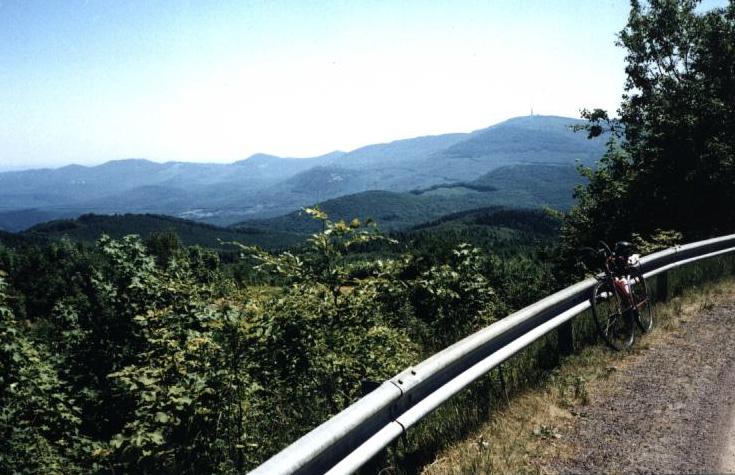 From next to the stone there is nice view to north, but going up to the tower there is a panorama around. Enjoy it!
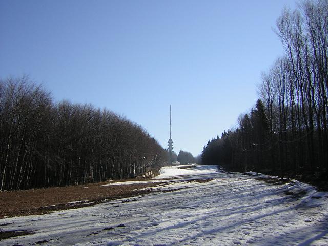
GALYATETŐ (964 m):
Pic from the slope of Galyatető towards the next peak, the Kékestető
Galyatető is the second highest point of the Matra mountain range. There are a few roads around it, we choose the most beautiful of them: the north side. On the 70% of the climb we push the pedals on a non-traffic road, which is open only for bicyclist and the cars of the forestry.
From Galyatető we have panorama only if we step up to the tower. ON the slope we will have a nice pics towards the KÉkestető. The second half of the slope is very light.
BÁNKÚT (880 m):
 This point is a most popular ski and hiker place in Bükk mountains. The first rest-house was built in 1931. Resurrectioned 1999 and the name will be White Eagle [Fehér Sas]. Up to the hill you can ride trough Bigfield pleteau which 700-800 meters average.
Another ways forestry road from Szilvasvárad trough Italy gate. This gate buldet italian prisoner of war. In downhill to th Mályinka you can see the beatuful Castle of Dédes (NE from Bánkút).
This point is a most popular ski and hiker place in Bükk mountains. The first rest-house was built in 1931. Resurrectioned 1999 and the name will be White Eagle [Fehér Sas]. Up to the hill you can ride trough Bigfield pleteau which 700-800 meters average.
Another ways forestry road from Szilvasvárad trough Italy gate. This gate buldet italian prisoner of war. In downhill to th Mályinka you can see the beatuful Castle of Dédes (NE from Bánkút).
Várhegy (699m) [Várkút 540 m]:
This point is a South-Bükk mountains. The rest house was built in 1925.
 Nearest is a "Stonely belvedere" where beatiful panorama about South-Bükk and Alföld (flat).
You can ride a rubble road two kilometers long from Eger Noszvaj passacol and this road will wait for you in downhill. From Eger you can see many vinerys.
Nearest is a "Stonely belvedere" where beatiful panorama about South-Bükk and Alföld (flat).
You can ride a rubble road two kilometers long from Eger Noszvaj passacol and this road will wait for you in downhill. From Eger you can see many vinerys.
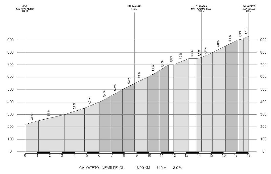
DIAGRAMS ABOUT GALYATETŐ AND KÉKESTETŐ
MORE DETAILS in a few days:
|