General experiences: In Slovakia the roadsurfaces are better, the traffic are less busy than in Hungary. The wide hard shoulders / edges of the main roads are ideal for bikers, so because the traffic on these roads are only normal and not too busy during cycling there it wont mean a problem. There is no reason for feeling fear because of the cars. The quality of the secondary roads are either not bad, but on these roads we can find somewhere rough surface or pot-holes.
Unfortunately in Slovakia there are no open well along the roads, streets, so the biker can fill the flasks only at petrol stations or private houses. In the Slovansky Raj or High Tatra(s) there are some springs along the roads.
Accomodation: With my tourmates in each of the five years we preferred to wild camping, usually at the edge of forests (the only exception were the nights in the High Tatra). I suggest to hide behind bushes, or turn off onto minor roads without any traffic. At the feet of the High Tatra (for example in Nova Lesna) there are a lot of private houses where we can rent/hire rooms or appartments.
In the course of my slovakian biketours a few of my most remarkable feelings came from such roads which went through fir tree forests and there were tipical flowers of the Tatra and Slovakia. (its colour is rose and they have a long head with a lot of flower-head on it. It can be more often seen in Slovakia, then in the Alps I think).
Maps: I have been bringing a 1:500.000 map with me for years, but for having more and detailed informations about the climbs I bought some 1:100.000 tourist-maps about the mountain-ranges. In the last few years slovakian bike-maps are also offered, which show MTBpaths and the steepness of the roads.
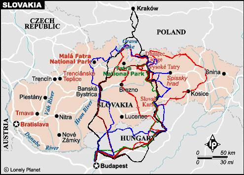
TO THE HIGH TATRA THROUGH EAST SLOVAKIA
Starting the tour from East-Slovakia, I suggest two routes to begin the slovakian bicycletour : (I suppose that the bikers dont want to cycle on busy main-roads, like the road (no. 3.) between Miskolc and Kosice and the other road between Miskolc and Bánréve):
ˇ Roznava Dobsina Dedinky (detour) - Poprad = 81 km + 1150 m heightdiff.
From Roznava (314m) to Dobsina the road ascends very pleasantly to between higher and higher mountains.
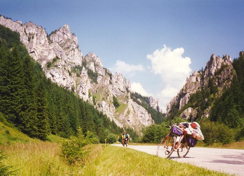
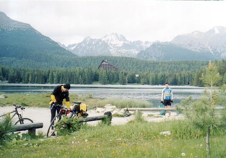
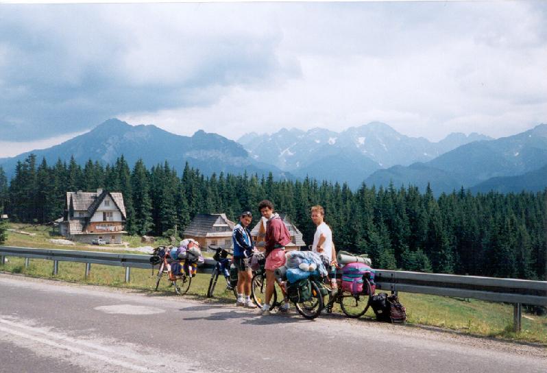
At the end of Dobsina starts a middle hard climb up to a 870m high saddle next to the lake Dedinky. On this 7,3 km the biker has to climb 400m heightdifference. The slope goes up with serpentinebends between fir trees and gives some nice views to the valley. Although the road doesnt go through Dedinky, the lake (there are 1000-1200m high mountains around it) and the village is worth seeing anyway (1st photo). We can take a round towards the lake, but we can go through the dam that swells up the water. Next to the village there are shore, where swimming is let. Remaining on the main road the land will be more romantic with some rocks, and besides the valley became narrower. During cycling in the valley we can enjoy the beauty of the fir trees, mountains, the clear air. At the entrance of a tunnel I suggest to choose to turn right into a canyon. That road is closed for the cars and only one kilometer long, but very romantic and beautiful! After the kilometer the road joins into the main road. Before Stratena there is a ca. 30m high rock next to the road, which can be carefully climbed. In every year when we cycled there, we went up to the top of that rock; it was a tradition for us.
Turning right, to Poprad a 1,3 km long 10-12% steep ascent goes to the 1056m high pass. While we are slowly struggling up, we can hardly notice the flowers, the fir tree fragrance.
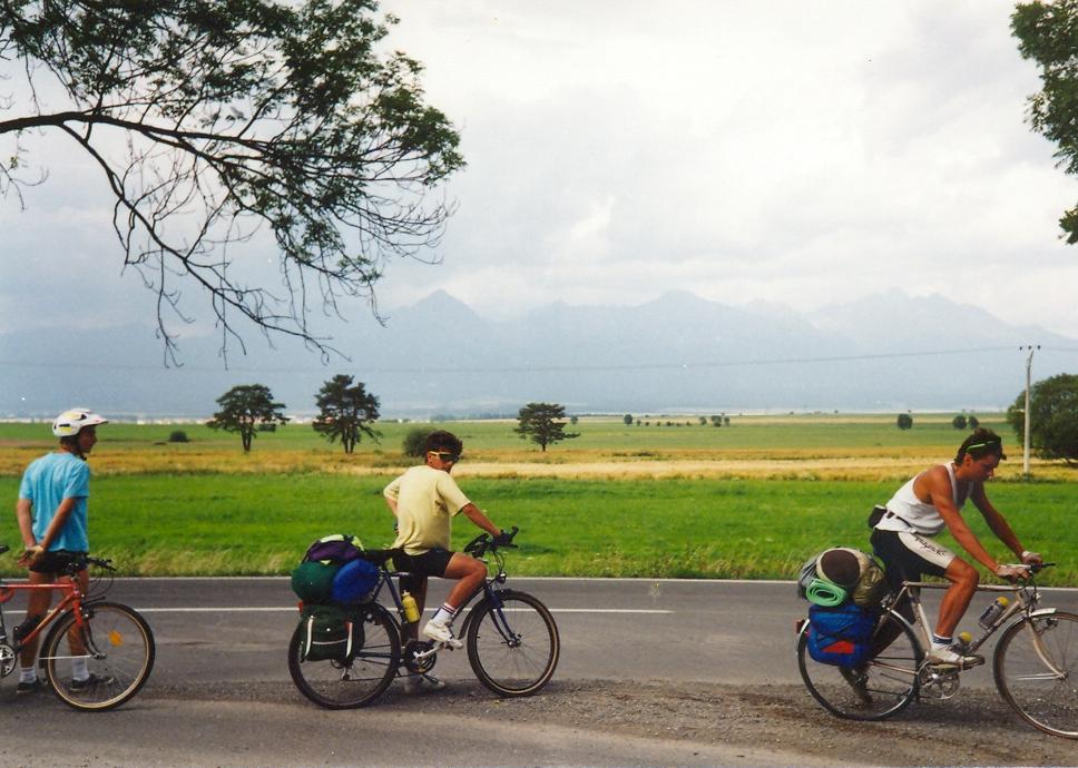
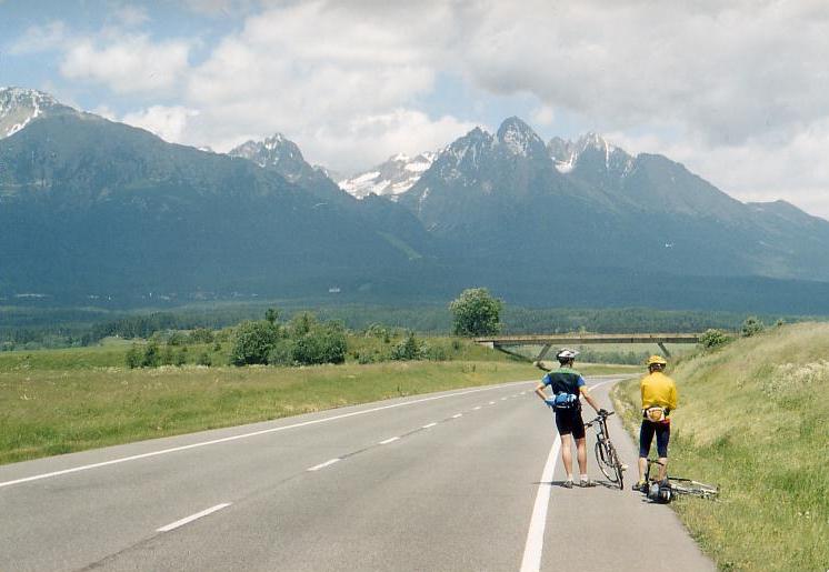
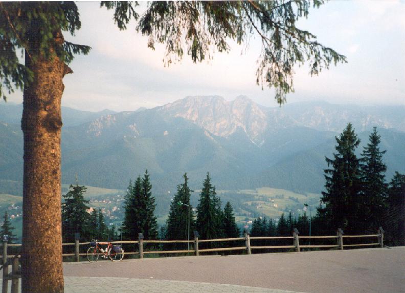
The steeper part of the descent is 6km long; somewhere twisting, but it has good surface. We can catch sight of the peaks of the High Tatra from Hranovica which seems to be full of gipsy inhabitants. Before Poprad there is one climb left, the Kvetnica; its light ascent is only 3 km long. After a short downhill there is maybe the best view to the High Tatra. Coming out from the forest we can see how the whole High Tatra mountain-range rises up to the sky (photo).
This june (2004) I plan to climb the heighest asphalted road in Slovakia, to the 1946m heigh Kralova Hola in the Low Tatra.
Roznava - Hnilec Dedinky Poprad = 92 km + 1410 m heightdifference
After Roznava we start with the same road (towards Dobsina), about I have written above, but at Gemerska Poloma if we turn right (towards Hnilec) we can enjoy cycling on a very calm, quiet road. On that road the bikers cant meet too many cars.
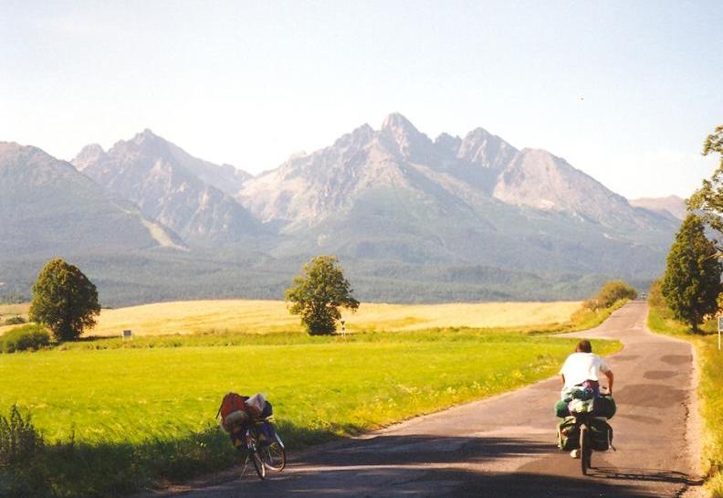
The climb has a long almost flat beginning section, then it goes into the forest, but although the gently sloping section is long, the 10 km long climb isnt too hard. Not much before the 909m high Sulova pass there is a spring under the fir trees. From the saddle the view extends only to the neighbouring mountains, on the saddle Im sure everybody feels the quiet, and mood as we would be at the the worldend. On the descent there are potholes, but for these the biker are compensated by the beautiful scenery towards north, towards the valley of Hnilec (photo). After a few kilometers long flat section we had to climb some kilometers onto the mountainside, where this road joins the other road that connects Spisska Nova Ves and Dedinky. Turning north (right) the climb continues to the 1069m high Grajnar saddle, while choosing the other direction (left), on this we can roll to the shore of the Lake Dedinky (11kms from the junction). From Dedinky we can reach Poprad on the same road, about which I have written in the last paragraph. (There is an other road towards Poprad through the Slovensky Raj and Hrabusice, thats rough and mended. The other, through Vernar is much nicer.)
Banréve Rimavska Sobota Hnusta Brezno Certovica-pass Liptovsky Hradok = ca. 132 km +1350 m heightdifference
From Bánréve our route comes closer to Rimavska Sobota through flat land; there are not too much traffic. After the town we push the pedals in a gently ascending valley northwards to between the mountains. After Tisovec the valley has a true slovakian character: in the lower part of the climb a stream and the fir trees together makes the valley be more atmospheric. In the middle of the climb the road goes under a viaduct. On this road there arent too much traffic too. The 725m high Zbojska saddle is similar to the Sulova pass, where we can meet a car only in every half an hour.
A gently sloping descent goes down to Brezno (500m), from where a 7% steep calm climb waits for the biker. The ascent is only 4km long, but is between the most beautiful ones. The ascent twists up through a fir tree forest and then on the 733m high situated top the biker gets a fantastic view to the whole Low Tatra mountain-range for his/her efforts (photo). This is one of my favourite passes. After a few kilometer long descent we arrive at Myto pod Dumbierom (650m), where a 10-11 km long middle steep climb goes up to the 1238m high Certovica pass.
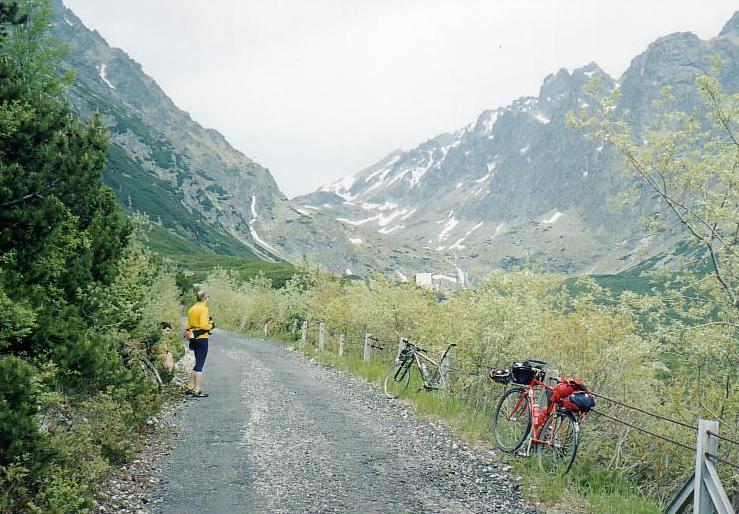
(From Myto pod Dubmierom we can take a ca. 30 km long detour (climb) into the Bystra valley and to the 1216m high situated Srdiecko hotel , to under the Chopok.) On the Certovica pass an old motel can be found, and besides there is a small but friendly restaurant and pension. The first half of the descent to Liptovsky Hradok gives opportunity to enjoy the speed, but in the second half pedalling is needed.
Side valleys / roads towards to Tatra, which is suggested to discover:
Dedinky Spisská Nová Ves Levoca - Poprad = 74 km + 770 m heightdifference
If we want to visit the east Slovensky Raj, or Spisska Nova Ves, going towards the High Tatra, there is only one road to choose: from Dedinky through the 1069m Grajnar pass. The 15 km long climb has 300m heightdifference, and is steep only on short sections. From a left bend we get a pleasant view to the whole valley. Its interesting that there is no prospect from the saddle, but a chapel. The descent has a pleasant steepness and bends and good surface. Going down towards Spisska Nova Ves we can enjoy rolling in the fir tree forest very much (photo). This road is ideal for bicycling: beautiful and not too hard. From Spisska Nova Ves the road ascends lightly to Levoca in a pleasant shady avenue. We catch sight of the town from a hillside. Levoca seems to be a nice small town: on the hillside some houses, with a church between them and a chapel on the hilltop.
With a 35km long detour we can visit the largest fortress of Middle Europe, the Spisské fortress. The short steep climb - on which we left the town - is followed by a 4 km long descent. Not far after it the fortress can be seen (photo): its much easier to keep on cycling, when we see, whats our destination. The road goes up to the 675m high situated fortress from behind. (In 1997 we had to pay 40 Sk for the entrance, and besides we should had to pay 50Sk for the videocamera. The whole building can be visited and gone through; there are stairs inside the wall of the tower; on a model of the exhibition we saw its hungarian name with pleasure, because 100 hundred years ago it was the part of Hungary. On the ca. 1 km long wall of te fortress can be also gone through.)
After Levoca we had to push the pedals for a few kilometer long on straight, bare and lightly steep climb. After a long downhill we arrive at Spisska Stvrtek, that is known for its church with a white tower and wooden top. To Poprad there are some 1-2 km long, somewhere 10% steep climbs.
Roznava Smolnik Mnisek Svedlar Dedinky =83 km + 1480 m heightdifference
Cycling eastwards from Roznava we had to cross a small hill to arrive at Krasnahorské Pohradie, which is known for its castle. I suggest the climb that starts behind the village only for enough trained cyclists, because on the next 9 km 660m heightdifference is to be gone through with some steep sections. (Its true I cycled there with 23 kg pack on my bike.) The ascent is hard for long and we cycle on an almost empty road to the 1030m high saddle, which seems to be much more at the worldend than the Sulova pass. In 1997 on that climb I met only one car. At the pass I found a gipsy who brough up the ladies from the hardly visited village to pick crops, berries. I felt it unbelievable! And that was true, that only 50kms from Hungary people picks berries. On the descent there were some potholes, but beautiful views too. In the valley the inhabitants looked at me in the helmet as I were an UFO. A lady who asked me about the time, didnt know the watch with digital numbers in it instead of the two hands (traditional clock).
ROAMING IN EAST-SLOVAKY AND A VISIT IN KOSICE
Poprad Spisská Bela Cerv Klástor (rafting) Stara Lubovna Lubotin Bardejov Giraltovce Turany Herlány Kosice Moldava nad Bodvou - Tornanádaska (H) = 336 km+ 2150 m heightdifference
From Poprad we cycle towards Kezmark (22km) along a river with looking back with goodbye to the mountains of the High Tatra. Besides the castle the church is also be worth visiting: the grave of the famous hungarian, Imre Thököly can be found inside that. It was a nice surprise to see the hungarian words on the grave and on the ribbons. From the area of Spisská Bela (or the valley of the Poprad river) there are two roads to cross the 800-1000m high Spisské mountain-ridge:
From Spisská Bela through the 949 m high Magurské saddle: The somewhere mended and staggered climbing road from Spisská Ves ascends up to pass with changing the 10% steep and flat sections. There are a few places on the mountainside, from where there are nice views to the hilly land of Spisska, its a friendly countryside. From the top the slope goes down to the riverbank of the Dunajec, but turning right (at the Magurské saddle) we can descend carefully to the 802m high Toporecké saddle which is only 2 kms away. Although the road is very bumpy and full of potholes, when I were there about half an hour before sunset it had a fantastic feeling, atmosphere: calm, quiet, without any traffic, with the sounds of the forest. And at the turn off there was a fantastic panorama towards the polish border, and the famous rock, the Trzy Korony.
If we would like to cycle on the easier road, I suggest to choose the only 802m high Toporecké saddle. To the village Toporec the route hardly ascends; unfortunately it is mended (in 1998) and there are potholes too; but with the speed of a bicycletraveller they can be gone round. Not far away after the village if we look back we can see the High Tatra last time; we can say goodbye to the snowy peaks. The last 1-2 km of the climb is about 8% steep. On the slope its better not to be fast, but careful because of the potholes. After Velka Lesná we can leave the brakes and can let the bike roll fast. (It was in 1998)
From Haligovce we can catch sight of the nice shaped rocks of the Pieniny mountain-range above the river Dunajec. The Trzy Korony, the peak at the end of the valley is situated just on the polish side. The RAFT-TOUR leads at the feet of it. This land is calm and not busy so its no problem to find a place for a wild camp. The raft-tours leave the start point, Cerveny Klastor in every 30 minutes, or based on the demands. The raft - in which I was sitting in 1998 - was made of 5 wooden digged out blocks, on which planks were taken. The people had to sit onto the planks and in the blocks. There were 20 of us in that raft. Onto the front of the raft branches were taken to save us from the water that sometimes bang against the raft. The raft was guided by two piskmen. One of them in front, the other at the back of the raft. I enjoyed very much how the piskman waited for the time when the raft swam to the right point in the bend, because that point was where he had to direct the raft into the right direction. The rafting-tour in the canyon lasted for about 60-70 minutes long. In 1998 the tour with the bustrip back to the departure costed 200 Sk. Instead of this there is a path at the bank of the Dunajec to walk back (1,5 - 2 hour long) to the departure. The whole trip was a fantastic experience! I suggest not to miss it!
We keep on cycling towards Stara Lubovna in a pleasant, hardly ascending valley through rare visited villages. In this region (maybe on sundays or when the ladies goes to the church) sometimes we can see ladies, girls dressed in national costume/dress. 1-2 km middle hard ascent after the last houses of Stranany we arrive at a saddle where from we can enjoy the picture of the Trzy Korony last time. After light rolling, pedalling we arrive at Stara Lubovna which is situated at the bank of the river Poprad. A 1,5 km long - at its end steep - climb goes up to the castle. Although we could hear pleasant music-voices from the building, because the entrance fee for the foreign tourists was the double as for the slovakians, we didnt want to go in. Towards Bardejov the route is flat for a while and follows the river, then after Lubotin it comes closer to the polish border and runs next to it for about 10 km long. The hilly land is nice and friendly. After the houses of Obrucne the road reaches its top at the end of a kilometer long steep climb. As the route is more and more far from the high mountains we can feel that the temperature is higher, and higher and coming closer to Bardejov not fir trees but leafy trees follows the road. On the slope down I couldnt already feel the slovakian character/atmosphere of the area; the land was just like in the Pilis, in Hungary. We can go fast to Malcov, but after the village the road needs pushing the pedals.
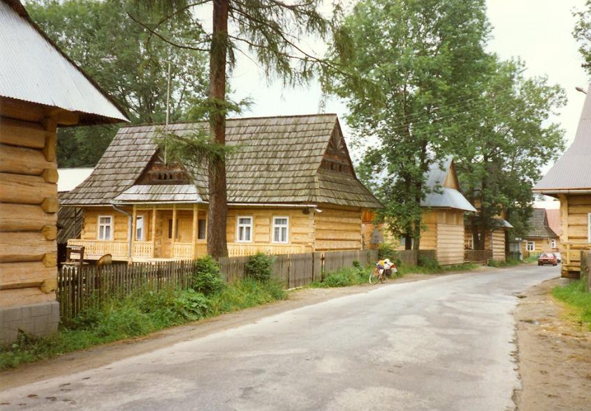
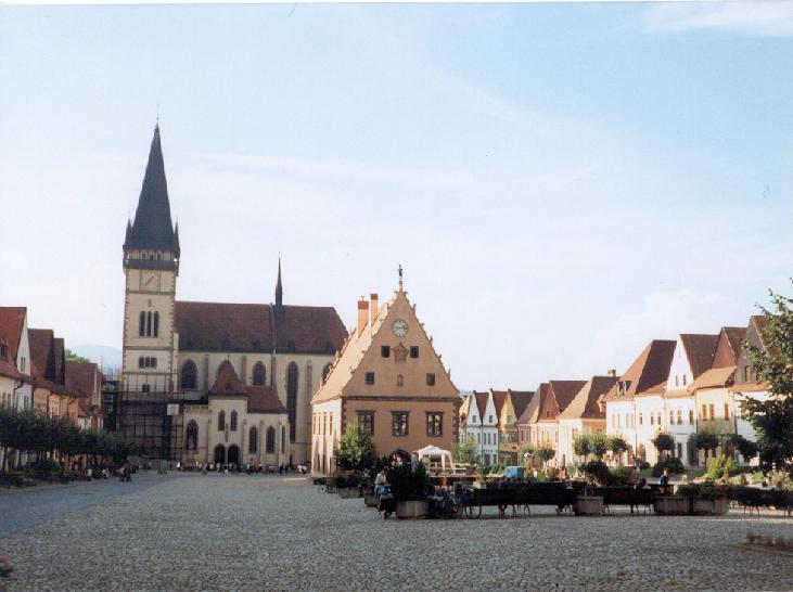
Bardejov (part of the UNESCO world heritages) is one of my favourite slovakian towns. I have never met with such a pleasant atmospheric main square in a town. We feel as the time were 100 years before: a church stands in the lower / north part of the square, in front of it the town hall can be seen, and round the square well renovated, somewhere decorated, atmospheric houses. (In the town nice and renovated wall of a fortress can be found too.) In 1998, when we cycled there, in front of the town hall (in the main square) a stage was built up, on which young were singing, playing music very well. We thought those youngs got chance to sing and play music to the people. Their music and the atmosphere of the main square was so well, that we were just sitting on the banks and listening to the music and enjoying the life for a while. Northwards from the town a few wooden church and an open air museum waits for the tourists. East-north Slovakia is famous for its wooden architecture.
If we dont want to cycle on the main road between Presov and Kosice, or we want to cycle more eastwards to discover those land, county, the Velka Domása bathlake can be a destination of a day. The road in the Topla-valley is flat, and the following mountains are only 500m high. Only one climb is between Giraltovce and Turany nad Ondovou; from this village cycling goes along the shore of the lake. About 6-8 kms after Turany, if we turn off rightwards onto a small road we will find good places to swim in the lake. After cycling its good to swim and rest our legs.
Leaving the lake and the hills, next to it an other - but smaller - lake will appear on our right side. Although in 1998 we set up our tent on the west side of this lake I dont suggest it: in 1998 we had very much insects during the night. (Maybe they were exterminated only around the previous lake.) Cycling southwards and coming closer to Vranou nad Toplou even the smaller hills are rarer. If we have enough time the Zemplinská Sirava lake and the Vihorlat mountain-range can also be visited. I suggest to choose the road through Herlany (between Vranou and Kosice), because along this road, in that village a spring can be found which erupts in every 32-36 hours up to the height of 30-35 m high. It can be called a geyser. The climb goes in a pleasant mountainside. Sitting on the bank in the forest on the 580m high saddle we can feel the calm, the quiet, the smell and the voices of the forests. We hardly met any cars.
On the slope its better to roll down carefully, there are some potholes on the road. (in 1998) The geyser of Herlany is just like a fountain in a park. Its not like the Old Faithful in the USA, in the wild nature. The eruption of the geyser takes place for half an hour long. The tourist office of Kosice can give information about the exact time of the eruption, but a clock also shows it next to the geyser. From Bidovce we cycle on the E50 road towards Kosice; to the town we meet with 2-3 hills to climb. Besides Bardejov the other town is Kosice which impressed me very well. It has also renovated houses in the center, a wide promenade goes through it, with a park, and banks in the middle of it. In the middle of the almond shaped main square a chuch and the theatre can be found; between them a nice fountain erupts for the voices of the music. Its another place where its enough only to sit in the shadow and listening the music, looking the fountain, or around the people, the houses, etc.
From Kosice to the border-village of Tornanadaska (Hungary) we cycle on the 2*2 laned busy main road, but there is enough place in the wide hard shoulder of the road. In the environs the romatic valleys of Haj and Sadielska is suggested to visit.
IN THE HIGH TATRA BY BICYCLE
Climbs at the feet of the High Tatra: There are some roads in the mountainside of the Tatra, which go towards the high peaks. Most of them have 10% steep sections.
Poprad Nová Lesná Magistrale : At first we leave Poprad on a gently ascending road; cycling through the meadow we can enjoy the panorama. After Nova Lesna the road turns to be continuously steep, and in the last kilometers it goes to between the fir trees, which gave to the road the true Tatra atmosphere.
Poprad Stary Smokovec: At the end of Poprad, at the flyover its not simply to find the right way towards Nova Lesná, as my tourmates chose the other twice. The other road - so if we go straight ahead - goes straight towards the mountains. I cycled on that road only once, but that was a memory. To the half it is hilly, but after about 5 kms it turns to be hard and 10-12% steep; we had to change gears. We have to push the pedals hard, but the view to the peaks compensate for it. Its interesting to cycle on that 2 km long straight steep climb between the fir tree forest. Downwards its easy to reach the 70 km/h speed.
Batizovce Gerlachov: this road as the others is flat in the first part, but then we need serious efforts to go on.
Tatranska Magistrale I. (the west side): Tatranska Lomnica (850 m)- Strbské Pleso (1350m) (Popradské pleso: 1494m) Liptovsky Hradok (637m) = ca. 62 km + 600 m heightdifference
From Tatranska Lomnica a medium steep climb goes to the Strsbké pleso (Lake Strbské) along the slopes of the Tatra. The wide road, the hard shoulder and the pleasant steepness makes it ideal for cyclers. Its
enjoyable and atmospheric to push the pedals in the mountainside between fir tree forests. The road after Stary Somokovec is flat for a while, but a few kilometers before the Strbské lake its middle steep (6%). About 1,5 2 kms before the lake a forest road which is closed for the traffic turns off. It ascends to the 1494m high, between 2300m high mountains situated Popradské pleso / lake. From the Strbské lake there is a beautiful panorama to the mountain-chain. After the lake a long and lightly sloping ascent goes to Liptovsky Hradok and we can say goodbye to the High Tatra.
(This june (2004) I plan to discover and get over the climb of the Sliezsky dom (1665m) from Tatranska Polianka.)
Tatranska Magistrale II. (east side): Tatranska Lomnica (860m) Tatranska Kotlina Zdiar Lysa Polana (polish border: 970m) = ca. 36 km +490 m heightdifference
Between Tatranska Lomnica and the polish border the road is similar to road between Tatranska Lomnica and the Strbske pleso / lake. Although the Strbské lake is situated 500m higher and the border at Lysa Polana is only 120m higher than Tatranska Lomnica, in spite of it the more heightdifference we had to climb towards the polish border. On the first few kilometers there are some views to the Lomnicky peak, then as the road turns northwards after Tatranska Kotlina there is a fine panorama of the mountains of the the East-Tatra, it is called Belianske Tatra. The village Zdiar is famous for its folk art. In the village a few kilometer long open climb starts, which goes up to an 1081m high pass with a rain-cottage and a spring. In the middle of the climb there is a buffet with nice panorama. From the saddle to the polish border ascents and descents change each other.
EXCURSION TO POLAND
If we want to visit the polish side of the High Tatra (I suggest it), we can cycle the tour to and back from Zakopane (100-120 kms) in a day, but besides an other advisable route is to come from east and go west (or the other direction) with a night at the feet of the polish Tatra.
ˇ Tatranska Lomnica Zakopane = ca. 45 km + 760 m heightdifference
The road to Zakopane is continuously hilly: 2-3 km long climbs and descents changes each other, with short flat sections sometimes. There is not much traffic there, but cycling in the fir tree forests and sometimes enjoy the views of the peaks give a great experience.
After Zdiar we had to climb 200m heightdifference. To the polish border there are a few pleasant rest places, like the buffet at Tatranska Kotlina, or the other wooden built buffet, restaurant after Zdiar. At the end of this climb, at 1081m we can fill or flask from a spring. Before the border the cyclist has to ascend only a small hill, but after it, Poland welcomes the biker with a 3km long climb.
On the top, next to the wooden house there is a junction. Going straight ahead after a few minutes we arrive at the Glodowka-meadow, from where we can enjoy the most beautiful view of the Polish Tatra (photo).
At the wooden house if we turn left the road slopes gently to Zakopane. In the center a very atmospheric promenade can be found. The 1100m high situated Gubalowka (photo)is a nice viewpoint of Zakopane. It can be reached both by cable car and by cycle on a steep ascent from Koscielsko. From the top we get a panorama southwards to the town and the High Tatra and northwards to the hills of the Podhale.
Zakopane Tatranska Lomnica = ca. 45 km + 750 m heightdifference (the previous route backwards)
From Zakopane a long and gently ascending climb goes to the top before the slovakian border. In Slovakia first we have to go through a short, than a 2 km long ascent, in order to enjoy the long downhill to Tatranska Kotlina after it. The rest with beer or tea, snack gives enough energy to climb the last ascent before Tatranska Lomnica.
Zakopane Trstena:
From Zakopane we can reach Slovakia on the west side too. While the route on the east side of the High Tatra is continuously hilly and the biker has to climb a lot, going west from the Tatra means light cycling. After leaving Zakopane, in Koscielsko we have to climb a short, but from the top a ca. 20km long and very gently sloping descent goes to Czarny Dunajec. In its first half we cycle on the feet of the mountains, than the land will be more open and we meet less forests, and more meadows. The village Chocholow has a fascinating atmosphere: its like a living open air museum (skanzen), full of wooden houses (photo). Here we can meet with inhabitants in true gural national / traditional costume. Between Czarny Dunajec and Jablonka we have to say goodbye to the polish High Tatra, because its the time, when we see it last time. Leaving the high mountains the air will be warmer too and we can meet with leafy forests again. In Jablonka I suggest to spend the last zloties in a shop. The road between the village and the border goes through bare meadows; the land is a little hilly. Westwards we can see the highest (1725m) point of the Babia Gora National Park. To under it an asphalted road goes, which ends at the height of 1018m.
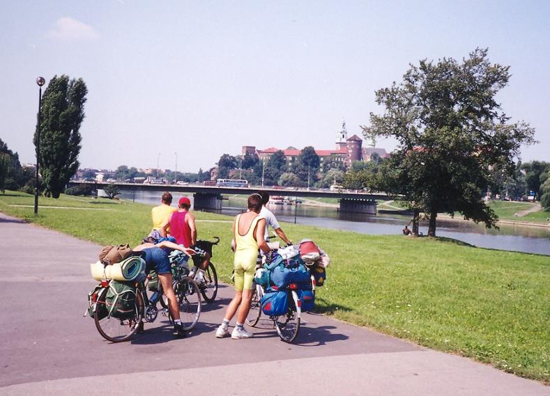
A VISIT IN KRAKKOW:(Lysa Polana Nowy Targ Rabka Myslenice - Krakkow = ca. 120 km + ca. 1000m heightdifference)
Krakkow, which town has maybe the most sightseeings (Wawel, Maria-church, posztócsarnok...) in Poland is situated not too far from the slovakian border, even by bike. Towards the city the route from the border by Lysa Polana goes through Tatranska Bukowina and Nowy Targ. The road between the top of the ascent after the border-station and Tatranska Bukowina is one of the most beautiful ones in the polish Tatra: there are some views to the snowy peaks. At Bukowina nice, good original hand made product can be bought. Leaving the village, the road descents gently to Nowy Targ. East from the town, in Debno a lovely wooden church of pilgrimage can be found (that was visited by the pope too). Between Nowy Targ and Rabka the road goes through a nice area with hills with nice views back to the Tatra; unfortunately the road is very busy and there is no hard shoulder. It isnt ideal for hobby bikers, but the views . This section is dangerous; be careful! (We cycled there late in the afternoon and enjoyed the sunset with the panorama).
From Rabka a more and more busy road goes to Krakkow. After Myslenice it is 2*2 laned, ascents small hills, but the climbs are about 1-1 kilometers long. We catch sight of Krakkow from a top of a hill. If we visit Krakkow, an other sight that must be seen is the salt cave museum of Wieliczka, where a lot of nice things (dwarfs, sculptures) are carved out. Going back to Slovakia from Wieliczka we can enjoy the nice and not too trafficked road, the variable land, and the middle high mountains, small villages. In one of them we have a talk with a friendly uncle who had lovely memories about hungarians. The last kilometers before Kasina Wlk are a little bit mountanious. In Kasina Wlk if we turn right, onto the road no. 98 we can lighty roll down to Rabka. Between Rabka and the border at Trstena the road climbs up to a 709m high saddle which is only the feet of the 1725m high Babia Gora, under which (up to the height of about 1000-1100m) an asphalted road goes.
BICYCLING IN WEST SLOVAKIA / THE ROAD BACK TO OUR HOME
Coming out from the small valley of the slovakian polish border we cycle along a row of trucks. (after the EU-join it will disappear ??) We arrive at Trstena on a pleasant descent. Cycling to Ruzomberok (and then to Zvolen) basically there are three routes to choose:
Trstena Oravsky Podzamok Dolny Kubin Ruzomberok = 58 km + 250 m heightdifference
For cyclists who would like to enjoy the light cycling and not to climb much, the one to choose is the road along the Orava river (the other is in the next paragraph). The road to Donly Kubin is continuously flat and goes between nice mountains, but sometimes there are too much traffic on the road (when we were there it wasnt). After Dolny Kubin which has a nice, quiet main square but is not famous about its nice buildings or history
on the road the cyclists have to face with 250m heihtdifference. The first part of the climb is gently sloping through meadows, but during the last 2-3 kilometers it will be steeper (7-8%), goes next to fir trees, but there are views too. On the descent to Ruzomberok its better to drive carefully; sometimes its 11% steep.
Chyzne (polish border) Oravsky lake Hrustin Oravsky Podzamok (fortress) Terchová (Vrátna dolina/valley) Martin Blatnica - Turcianské Teplice Banska Bystrica Zvolen = ca. 259 km + 1750 m heightdifference
If we dont want to cycle on the main road (E77), the other opportunity to cycle is the next valley westwards from the Orava valley, which is a quiet one with minimum traffic. Biking through it we can continue our tour in the Small-Fatra, and in this case we can visit one of the most beautiful valley of Slovakia, the Vratna canyon.
At the start of the town Trstena if we can manage to find the right road, street the climb begins with a steep section, but for the efforts it gave us a nice view: down to the Orava / Oravsky lake and behind it the Beskidy mountain-range, in the middle of it with the 1725m high Babia Gora. At the shore of the lake pleasant free bath/swim places and buffets can be found. In the valley of the Hrustinka stream we hardly meet any climbs, but in Babin the short climb up to a hill is 10% steep. From its top we can see the next ascent on which our route goes back to the Orava valley, to the fortress of Orava.
At the end of Hrustin a table with 12% steepness frightens the cyclists, but the climb has this steepness only for 1-2 short sections; usually it is 6-7% steep. After admiring the fortress of Orava, the next 19 km to Parnica, along the river is flat. In a confectioners at the main square of Dolny Kubin we can get enough energy for the next section the the Vratna canyon in the Small Fatra. In the village Parnica I suggest to turn right and choose to visit the Small Fatra. In the calm, quiet valley of a stream its a pleasure to cycle: the plashing stream, high rockwalls and twisting but hardly ascending (steepness about 1-2%) road. Before Zazriva we should turn left towards the Vratna valley. First we push the pedals along some nice holiday houses, but in the last 1-1,5 km our speed fall down to 6-8 km/h, its so steep. That was a memorable climb from 1997: I could to ascend only with standing up from the saddle and with using my arm-muscles when I was moving left right the bike under me. From the top there is a nice view to the strange shaped Rozsutec. (On a not too old map I read that this climb was 14% steep.)
For the night there is a camping in Terchova, but outside the National park places for wild camping can be also found. In the National Park its forbidden wild camping. In every case I suggest to spend half or a whole day in the Vratna valley. The guidebook also praise it very much, and the prospectuses show this place, canyon as one of the slovakian main attractions. And this is the reality: ca. 200m high rockwalls, indented rockpeaks, plashing stream, fresh-green plants, fir trees. After the tight canyon the valley will be open: keeping on cycling the road ends at the ca. 700m high situated Vratna tourist-house. There are 1-2 small asphalted roads if we turn left after the canyon. From these roads we can get another nice views.
Leaving Terchova we cycle through pleasant, quiet small villages to Varin, where there is a pedestrian bridge to cross the Vah river. With this cross we spare 25 km cycling. In the Vah valley cyclists can push the pedals on a wide, shady, flat road to Martin; although the road is busier than the other before. During biking we can enjoy the view to the Strecno fortress. From Martin the road southwards, to the Big Fatra is (it was in 1997) constructed by concrete-tables. For this smooth road the views compensated us. Cycling towards the startpoint of the following National Park (the Big Fatra National park), we can continuously enjoy the picture of the Tlsta mountain, because its just in front of us. From Blatnica I suggest to cycle in the Gader and Blatnica valleys to its ends. Both start with asphalt surace, but ends with good shaped gravel-road. About the Gader valley I wrote this in 1997: As the valley gradually became tighter, the quality of the road changed worse with more potholes. In this valley nice vegetation welcame / welcomed me. Sunshine, blue sky, green fir trees, glittering white rocks, plashing stream, wooden house and fresh green plants It was just in the paradise! I found it fantastic: not only the rocks, the canyon, but everything together./br>
From Blatnica, if its no problem to climb a short 10% steep ascent for which we will be compensated on the top of the hill I dont suggest to go back to the main road, but to cycle to Mosovce then to Turcianské Teplica - on the mountainside. On the top the variable colours of the nature were fascinating: green forest, white rocks and the clear blue sky (photo).
About the long and gently sloping ascent (for 12 kms only 355m heightdifference), the passroad of Hermanec the guidebook wrote nice things too. And its right, although the east side of the pass is a little bit nicer or more romantic. One of my tourmates - who came from the hungarian Great Plain, but were with us in the Tatra 6-7 times - said about the ascent: On such a road I could cycle even to the sky. J The climb goes along a plashing stream for long, then on the mountainside. On the top I enjoyed very much how three bends followed each other: the road twisted for 500m long in such a way, so that from the first I could see not only the next but the other after that. It was like a snake. The guidebook thinks, that there is a similarity between this and the austrian Semmering-area, because both has nice fir tree forests, rocks, twisting roads, also twisting railway-line and a viaduct.
To the main road which comes from Donovaly - the descent was middle steep, after that only light to Banska Bystrica. This town is one of my favourites in Slovakia besides Kosice or Bardejov. Its main square is well redecorated. The minimum time to spend there is 1-2 hours: its worth having rest, sitting into a confectioners and walking around the square, which is closed for the traffic / pedestrians. (Cars are not allowed to be there)
Between Banska Bystrica there is two roads to choose: the 2*2 laned, lightly hilly main road, and the hardly trafficked road through small villages eastwards from the other. Zvolen has been redecorated in the last years too, its another nice town. I discovered its main square only 8 years after my first visit there by bike. (About the roads, routes between Zvolen and the hungarian border I will write in the part of the one day tours.)
ˇ Chyzne (border) Podbiel Zuberec ( + open air museum) Liptovsky Mikulas = 74 km + 550 600 m heightdifference
This route is the shortest towards the Liptovsky lake or to the High Tatra, but it goes up to the height of 1000m, but its worth.
From the polish border we arrive at Trstena on a light descent, from where we have to cycle some flat kilometers to Podbiel. Turning eastwards the road ascend gently to Zuberec, where its worth spending a few hours (or a day) in the open air museum between the forests. Next to the museum a forest-road goes to the feet of the high mountains. The other road goes to the Liptovsky lake through a quiet land with some nice panorama. The first few kilometers are flat, then it goes up from step to step. After some ascent the road goes on a plateau to the start of the steep descent, where from there is a great, fantastic panorama to the Lipto region with the lake, villages and the Little Tatra opposite of us. The steep descent twists down through fir tree forests, small meadows, and there is hardly any traffic. (In 1998 we climbed it from south in rain, so I would like to go back in sunshine since then. It should be one of the most beautiful roads, climbs of Slovakia)
Liptovsky Mikulas Partizanska Lupca Donovaly Banksa Bystrica Zvolen = 113 km + 1060 m heightdifference
Although the traditional routes of our Tatra-tours didnt contain this valley, the Lupcanka valley where I cycled in 1995 - remained one of my favourite valley in Slovakia. The minimum traffic gives an opportunity to enjoy the cycling in the quiet nature. Although the last 1-2 kilometers before the 1100m high saddle is 12% steep and they are tiring (with 20 kg weighted pack), but pushing the pedals in that pleasant and calm fir tree forest and the fast descent (wide road and good asphalt) on the other side compensate the cyclists for their efforts. For those who doesnt like climbing by bike I dont suggest this route, because they dont have to ascend this pass, but only the other to Donovaly, which has 350m heightdifference. (Who want to spare the efforts, they should cycle from Ruzomberok to Donovaly, which makes the cyclists warm for step to step on the long light ascent.
After Liptovská Osada (where the two road from Ruzomberok and the Lupcanka valley - comes together) the main road will be steeper and with sometimes about 9% steepness reaches the 960m high situated Donovaly holiday village. From the top a thin road goes eastwards up to a hill from where there is a nice panorama back to the village and the pass. (photo) The descent to Banska Bystrica is not too dangerous, but I suggest as a table does it too to be careful. (About the route between Banksa Bystrica and Zvolen I have written 2 paragraphs before. )
Between Zvolen and Sahy (border) maybe its the simpliest and easiest to choose the road through Krupina and Hontianské Nemce. Its a main road, but it is only middle trafficked; there arent too much trucks, and there are a wide and good hard shoulder. First the road goes through a canyon, its hardly ascending. The light climb will be steeper only for 2 kms long (at Babina). Before and after it we can cycle with a good speed. (The top is situated about the height of 400m.) As the ascent isnt steep upwards, the other side is the same: it goes down to the height of 160 200m through 15-20 km.
( There are other nice routes in the mountains eastwards or westwards from this main road, but on them the cyclists have to climb serious ascents. About that ascents, routes you can read in the next paragraphs.)
ONE DAY LONG TOURS TO SLOVAKIA (STARTING IN HUNGARY)
Stiavnické pohorie: mountains around Banská Stiavnicá:
The Javorie, north from Velky Krtis
A road not too far from Hungary, but its as it were at the end of the world: the valley of Rimavica and the Polana mountain-range
From Krupina to Balassagyarmat (HUN): not on the main road, but through the mountains:


 A gently sloping descent goes down to Brezno (500m), from where a 7% steep calm climb waits for the biker. The ascent is only 4km long, but is between the most beautiful ones. The ascent twists up through a fir tree forest and then on the 733m high situated top the biker gets a fantastic view to the whole Low Tatra mountain-range for his/her efforts (photo). This is one of my favourite passes. After a few kilometer long descent we arrive at Myto pod Dumbierom (650m), where a 10-11 km long middle steep climb goes up to the 1238m high Certovica pass.