Linkjeim
Túráim:


Szerzői jogok!


Hágóim bemutatása
(1994-2004)
2003 - Horváto.,
Montenegro
2002 - Görögo.
2001 - Svájc
2000 - Dolomitok
Garda-tó
Velence>
1999 - Tátra
1998 - Tátra
1997 - Tátra
1995 - Tátra
1993 - Tátra
Cikkeim
További
túraleírások
|
Júl. 9, Friday: 1st day: 94 km + 370 m heightdifference
Budapest - TRAIN - Szombathely - Schachendorf (A) - Burg - Eisenberg (415m) - Eberau - Szentpéterfa (H) - Körmend - Zalalövő - TRAIN - Ljubljana
I travelled by train to Szombathely, tan because I had time to the next train starting from Zalalövő, I chose not the straight road to Zalalövő, but a loner version through Austria: Szombathely - Schachendorf (A) - Burg - Eisenberg (415m) - Eberau - Szentpéterfa (H) - Körmend - Zalalövő.
On the austrian side I was bicycling on well builted roads, thorugh / with a little traffic. The area around Eisenberg seemed a good winearea, with winehouses, winecellars, and with beautiful panorama from the hillside towards Hungary. While I was enjoying very much the nature and the region, after I time I realised that I spent almost too much time, so I had to hurry to catch the train. First at Zalalövő I felt stress: The ticketseller lady told me, she needed half an hour to do the whole process of that ticket preparing, because she had to kommunicate with Szombathely about the ticket for the exact place ont he train, etc. After my definite aplomb at last I could got my ticket in time. The next problem of the day was that when I took my bike onto the train I lost my cyclocomputer. Next morning I had to buy another one in Ljubljana.
July 10th, Saturday, 2nd. day: 122 km + 670 m heightdifference
Ljubljana - Postojna - Sezana - Trieszt (I)
Trieszt (15:47) - TRAIN - (17:38) Mestre (18:16) - TRAIN - Bologna (20:15)
I started the morning with early wake up and searching for bicycleshop to buy a new cyclocomputer, to be able to reach the train at Trieszt int he middle of the afternoon after about 100 kms of cycling. To Logatec in backwind I enjoyed pushing the pedals with 27-30 km/h, but the mountains seemed to change the wind, because after Postojna I had to face with headwind., In the last hour, and at the a plateau not far from the border I had to fight very much, almost to my last strenght. I often updated my plan, whether I could catch the train. Beside the fight, struggiling I had only a little bit of water, but I had no time to fill my bottle. I had fortune in Triest, because the slope went to the center, only 2 kms from to the train station. At last I had 25 min to buy the ticket and find the train.
Train-travel in Italy: Sometimes I could speak english with the cashiers, other times I couldnt. Naturally tickets can be bought for the whole travel, although it has 3-4 or more parts with another trains. You can buy biketicket for 24 hours or for only that exact section. The biketicket has two parts: one part has to be seen o the bike, the another you has to show to the tickercontroller. ITts IMPORTANT, that the tickets must validated (date and time onto the ticket) at the yellow machines at the station before travelling. The place for the bikes can be found at the beginning or at the end of the train; its signed with a logo on the side of the train. Usually there is place for 10-12 bicycles.
July 11, Sunday, 3rd day: 84,3 km + 550 m heightdifference
Bologna (10:25) - TRAIN - (12:37) Voghera (13:02) - TRAIN - Imperia (16:13) Imperia - San Remo - Camporosso (a camping not far from the french border)
I enjoyed travelling on italian trains, changing trains and that I arrived from one area to an other, I get "acquainted" with new regions and also enjoyed the feelings of the train stations. Before and after Genova the train went through a tunnel, and after it arrived at the sea. It was a good feeling to be at the italian Riviera, because I had never been there before. The train was travelling just next to the beach. After getting off the train I was bicycling on the italian Riviera through for excample San Remo to the french border. Although it was the Riviera, I had to cycle 20 kms to find the first store to buy food. Almost everything was closed. The store was SPAR! After standing up my tent in the evening I cycled into France, into Menton, where from I climbed a little climb. If we compare the prices of the camps at the Riviera and at the French Alps, the formers are dubble so expensive.
July 12, Monday, 4th day: 110,91 km + 840 m heightdifference
Camporosso (I) - Monte Carlo (F) - Nizza - St Saveur sur Tinee (510m)
The morning I spent time with looking around in Monaco and Nizza. First I was a little bit sad about that I couldnt find the most famous parts of the F1 circuit, but after a time I thought that for me not the F1 circuit-visit is the important, but cycling the famous cols, climbs of the Tour de France. IN the early afternoon I got a storm and rain, but fortunatelly I could find a fast-food restaurant in a short time, where I could wait for the end of the bad weather. Because of that 2 hours delay, I had to bicycle to sunset to reach the planned (super) calm, municipal camping of St Saveur de Tinee.
Júly 13, Tuesday, 5th day: 100,72 km + 2300 m heightdifference
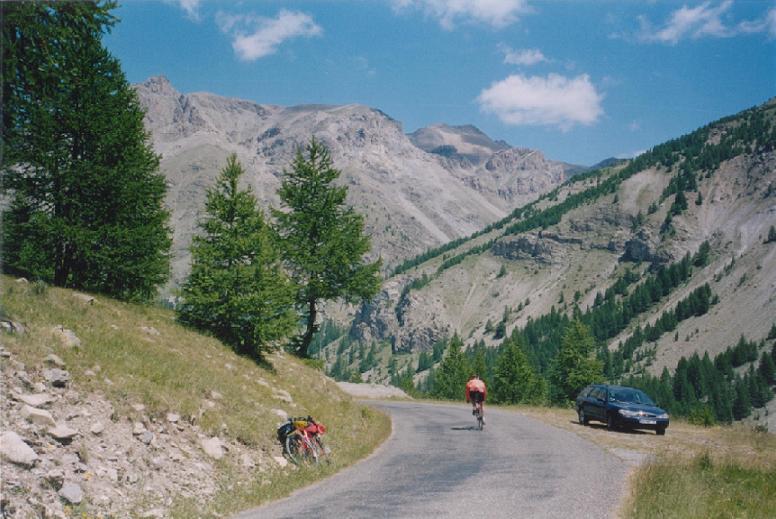
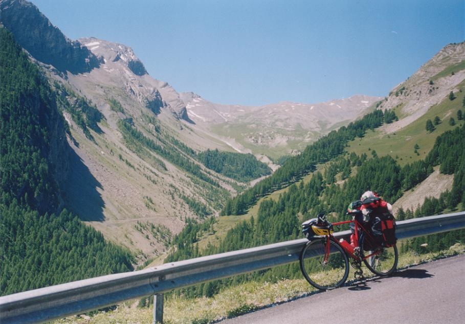
St Saveur sur Tinee (510m) - Isola - St Etienne de Tinee (1150m) - Cima de la Bonette (2802m) - Jausiers - Barcelonnette (1136m)
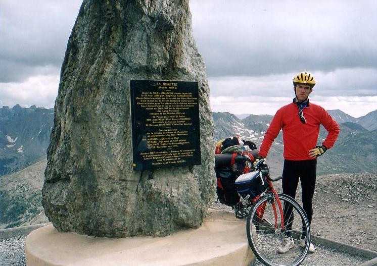 That was one of those days, I had been waiting for a time: to reach one of the heighest asphalted passes of the Alps and to climb more than 2000m heightdifference continuously (with a few rests) with panniers. From St Saveur the climb was more than 50 km long and the heightdifference was 2300 m. The 2802m high CIme de la Bonette is called by the french the highest asphalted pass of the Alps, although its not a real pass / col. I was very happy to climb this col by a bike with 24kg weighted panniers. I thought that most of the cyclists climb this by only a light bicycle, and there are only a few who climb it by a strong and not light bike with packs on it. And maybe there is no hungarian among them. Maybe. (Up to that time I didnt read any bicycletour of hungarian people when thay could reached this pass.) The valley was calm, with a little traffic, almost no snow (only far from me). The interesting thing about the col was that while average steepness o fit was about 6-7%, the last kilometer was 15% steep. It was no surprise that I had to stop 2 times ont hat section, but I hadnt push it; I could climb it on the bike. From the camping I needed 4 hours and 35 mins to reach the col. It was funny that only the first mountinous day of my tour I reached the heighest point. I was glad to hear the applause of the people there. After a few photos about the mountians around and about me, I put on warm clothes and then I was rolling down 25 kms to jausiers and than towards to Barcelonette to the next camping.
Júly 14th, Wednesday, 6th day: 126,96 km + kb. 3300m heightdifference
"REST day", with only a day-pack (4-5 kgs): Barcelonnette (1136m) - Col de la Cayolle (2327m) - St Martin (1035m) - Col des Champs (2191 v. 2045 ?m) - Colmars (1235m) - Col dAllos (2240m) - Barcelonnette (1136m)
 About the Col de Cayolle I had read twice the same: by the cyclotourers it is said to be one of most beautiful cols of the Alps. Light, not too steep beginning, for a few kilometers between rockwalls, next to a stream. The valley is calm, nice, friendly, with flowers, green plants, and with groundhog-whistle, IT was really beautiful, but as I couldnt see any snow anywhere, I found for excample the col dIseran more beautiful. The Col de Cayolle wasnt a hard climb. To the second climb of the day - Col des Champs - I had a long rolldown. On the first kilometers I took the bends, hairpins with fresh and with impetus,
it was pleasure to push the pedals, I felt very well. At the two third of the cilmb, after I left the forest, I had to fight against the strong wind, that came from the col. It wasnt surprise, that a scene came into my mind from a scientist TV magazine: as mountinclimbers fight up to the mountain against snowy wind. I started my last climb (Col dAllos) with a bad mood, because I had headwind and the sun was going down. I had about one and a half hour to the sunset. The first half of the slope I didnt enjoy, but after Allos I felt well: the sunny 5-6% steep serpentine was. pleasant. Because in France the sun goes down one hour later than in Hungary, I wasnt afraid about that I had rest until 8:30 pm at the col. ON the sometimes risky road, which went down at the steep side of the mountain I arrived back to Barcelonette at 9 pm. The day finished with firework; it was 14th July, national holiday.
About the Col de Cayolle I had read twice the same: by the cyclotourers it is said to be one of most beautiful cols of the Alps. Light, not too steep beginning, for a few kilometers between rockwalls, next to a stream. The valley is calm, nice, friendly, with flowers, green plants, and with groundhog-whistle, IT was really beautiful, but as I couldnt see any snow anywhere, I found for excample the col dIseran more beautiful. The Col de Cayolle wasnt a hard climb. To the second climb of the day - Col des Champs - I had a long rolldown. On the first kilometers I took the bends, hairpins with fresh and with impetus,
it was pleasure to push the pedals, I felt very well. At the two third of the cilmb, after I left the forest, I had to fight against the strong wind, that came from the col. It wasnt surprise, that a scene came into my mind from a scientist TV magazine: as mountinclimbers fight up to the mountain against snowy wind. I started my last climb (Col dAllos) with a bad mood, because I had headwind and the sun was going down. I had about one and a half hour to the sunset. The first half of the slope I didnt enjoy, but after Allos I felt well: the sunny 5-6% steep serpentine was. pleasant. Because in France the sun goes down one hour later than in Hungary, I wasnt afraid about that I had rest until 8:30 pm at the col. ON the sometimes risky road, which went down at the steep side of the mountain I arrived back to Barcelonette at 9 pm. The day finished with firework; it was 14th July, national holiday.
July 15th, Thursday, 7th day: 142,33 km + ca. 2800m heightdifference
WITH PANNIERS: Barcelonnette (1136m) - St Paul - Col de Vars (2111m) - Guillestre (1000m), then
 with little pack: Guillestre (1000m) - Chateau Queyras - Col Agnel (2744m) - Chateau Queyras - Guillestre (1000m)
Although the Col du Vars isnt counted to between the famous cols, buti t had hard sections. It is a nice col with little bit snowy mountains, with firtrees, nice meadows and flowers. Rolling down to north I could see the 4000 m high, snowy peaks and glaciers of La Meije. At around Guillestre (1000m) I felt hot air. After a fast energy-level "filling", and standing up my tent, I started immediately up towards the 2744 m high Col dAgnel. To Chateau Queyras the road went in a hot, thin, deep canyon; the stream babbled about 50 meters down from me. Not far after the village started the real climb; from there I had to go up 1300m heightdifference. The whole slope dont give a memorable picture until the last 5 km. Up to there its a boring, middle-hard climb, but the last 5 kms are fantastic: nice mountains, rocks, snow at a few places, and the serpentine. I had fortune, because the landscape was more beautiful because of the evening lights of the Sun. The col is istuated at the French - Italian border. AS there was almost no traffic, I had to step to the middle of the road to stop the next car to take a photo about me. The car wanted to stop too. Although 2 days ago the Ciime de la Bonette was about 60 m higher than this col, I felt more success-feeling and I felt more honour here, because of the last 5 kms, the surrounding mountains, and that col I had to cross in every case, but this col was an opportunity. It wasnt sure that I can climb this col this afternoon, I only could hope it. About 1-2 kms before the top I could feel the joy: "-Ive done it! Ive succeeded it!" The homeway was about a hour long rolling-down.
July. 16th, Friday, 8th day: 121,81 km + 2234 m heightdifference
Guillestre (1000m) - Col dIzoard (2361m) - Briancon - Col du Lautaret (2058m) - Bourg dOisans (730m)
 In the hot july swelter I struggled me up on the climb of the hot, dry, rocky south side of the Col dIzoard. On this road I could met with a lot of bicyclists; I felt well, when not too far from the top 2 friendly biker told me "-Bravo!" Up to that time I could only plan and read about how other biketourers felt themselves on that climb, but at that time at last I could enjoy the feeling of the Col dIzoard, the rocky Casse Desert, and to stop at the monument of L Bobet and Fausto Coppi, the heroes of the 50ies. I had fortune on the climb, because I could cycle up the col, as I would had asked for it: during struggling under clouds, but on the top enjoying the sunlight. Nothwards grey and dark clouds covered the sky, moreover I heard the voies of thunderstorms from east. The slope to Briancon was perfect, plain asphalt, I think it was because the Tour de France climbed it last year (2003). On the upwards side about 1 m wide place was signed with a line for the cyclers. Halfway to the town, the rain started to drop, so I had to increase my speed and to fleed in front of the rain. I arrived into the town under clouds, the wind was blowing, so sitting on a bank I couldnt enjoy too much the delicious cake I bought in a shop. I had to go under a place where I was protected from / against the rain. After the rain seemed to go away (30-60 min), and the clouds were scattered northwards I went on cycling on the not too hard slope of the 2058 m high Col du Lautaret. Sometimes it was raining a little bit, oth time it stopped, but I hoped that - because Northwest the sky seemed cleared or lighter - I could cycle from under the grey clouds, which made me afraid of the rain. I finished the last 3 kms of the climb in rain, and besides the snowy, more than 4000m high La Meije - which had a glecier although on its side - didnt give me optimism, because it was in the clouds above about 3000m. The weather didnt seemed too friendly there. On the col there was about 12-13 Celcius (at 19 pm.). ON the descent I got a heavy rainfall, which result was that my shoes leached a little bit. As I hoped, at the altitude of about 1000m, I went from under the rainclouds and after enjoying a rainbow arrived at Bourg dOisans under evening sunlight. 5 days before arriving the Tour de France there a lot of fan were there, along the road in their caravans or motor caravans and the camping that I found also opened an extra place for them (and for me also). Im the camping I could found mainly belgians, holland people, fans from Great Britain, USA, germans, etc.
July. 17th, Saturday, 9th day: 76,95 km + 2241 m heightdifference
"REST day", with only a day-pack (4-5 kgs): Bourg dOisans (730m) - l Alpe dHuez (1860m) - one of the first hainpins (970m) - l Alpe dHuez (1860m) - Col de Poutran (1996m) - Bourg dOisans - 1 km ascent in front of lAlpe dHuez.
 It was a very memorabe day of my on the most legendary climb of the de France: Alpe dHuez. Although I didnt planned that I would climb up to the finish without any stop, during pedalling up, I decided not to stop. I enjoyed that although I pushed the pedals of a touringbike with 3-4 kg pack, I overcame about 30 other biker, and only about 5 of others were faster than me. At a bend a young guy asked me if he could pour cold water ontom my shoulder, and I bowed: Okay, Lets try how the professional racers can feel themselves! But it was cold! Maybe two hairpins before the skicenter, lAlpe dHuez a professional photographer took three pictures about each biker and when we rounded him, at last he gave us a small card with the name of their photolabour on it, ot order photo, if we would like. I ordered one, and it was a fantastic photo.
AFter the first climb, next time I climbed from the 2nd or 3rd hairpin, buti n that time when I wanted to take photos or videofilm, I stopped. At this occassion, I could really enjoy the feeling, the panorama, etc. There were a lot of fans along the road, with their caravans, cars, tents, flags, etc. After arriving and looking around in Alpe dHuez I pushed the pedals up to the Col dPoutran, however I wanted to visit another col, de col dSarrenne. It was 3 m lower than the other. At the evening the middle of the football ground would had been infested by the lately arrived fans.
July 18th, Sunday: 10th. day: 90,07 km + 2182 m heightdifference
Le Bourg dOisans (730m) - Col du Lautaret (2058m) - Col du Galibier (2645 m) - Valloire (1430m) - Co du Telegraphe (1520m) - St Michel (711m)
On Sunday morning a lot of bicyclist was pushing the pedals upwards to the col du Lautaret and the 2654 m high Col du Galibier. Between them I also cycled that way, but I had another 24 kg to take with me on the bike. Twice I met with guys with light racebikes, who had pace as was mine and overcame me, but dont had the faster speed. These times I became a little bit angry (why should you overcome me, if you are not faster with a light bike?)) and overcame them and forced a faster pace, that they were happy to cycle behind me. First time I cycled 3-4 kms before 5 german guy, than not far from the col du Lautaret I had a little bit race with a pair. On the col I had a little bit rain, but fortunatelly not too much. I felt funny, that I was second time ont hat col, and every time I got rain. The south side of the legendary Col du Galibier was wonderful, and surprisingly not too hard to the tunnel. There is view to the valley towards Briancon, to the junction and the roads at the Col du Lautaret, to the snowy La Meije with its glaciers and the valley towards Bourg dOisans. IN front of the tunnel there is a monument of Henry Desgragne, the founder (1st organizer) of the Tour de France. At that place most of the bikers choose to climb another kilometer (although its hard) to the top and not to roll though the tunnel. On the descent I had rain again, but not too much. Fortunatelly in St Michael I could stand my tent and go shopping in dry weather. The rain started to drop after the sunset.
July 19th, Monday: 11th day: 148,14 km + ca. 3600m heightdifference
"REST day", with only a day-pack (4-5 kgs): St Michel (711m) - La Chambre (495m) - Col de la Madeleine (2000m) - La Chambre (495m) - Col du Glandon (1924m) - rolling to the dammed lake (1700m) - Col de la Croix de Fer (2068m) - St Jean - St Michel (711m)
I had two hard ascent to climb this day, I choose which to start only towards La Chambre. I thought the lighter would be Madeleine, because I knew, the end of the Glandon would be about 14% steep. Col de la Madeleine was 20 kms long and average 7,5% steep, without any light section. It hasnt views to a lot of snowy mountains, but mountains with trees, meadows, and far away with rhigher peaks. In the last few kilometers, I met with a guy and his father; the younger of them unfortunatelly wanted to compete with me, however he had about 3 kgs lighter bike and no pack (mine was about 4-5 kgs). I like cycling when I caan cycle on my own pace and can enjoy the nature without any hurry, but when someone would like to compete with me and he thinks me not enough strong, then I like to show my strengths. In the last 3 kilometers we cycled almost together, int he lst km we testd the other, and at the end I sprinted better and won. I was very glad to win with heavier bike and pack. After he gave me his hand I took photos, had rest for half an hour. After rolling down to La Chambre, I had to face with the Col du Glandon. Surprisingly it was lighter than I thought. On the first half I could go very well, I found my rythm. AFter eating int he village the climb wasnt so hard, but its true I had 30*34 gears (front - back). I enjoyed taking photos and videofilms about others with racebikes, who struggles cycling up. I saw two guys, who had to get off their bikes, it was too hard for them. From the Glandon, to get more heightdifference for that day I was rolling down about 4 kms int he Col de Croix de Fer valley, and then turned back at a dammed lake. The Croix de Fer was the 11th col above 2000m int he French Alps for me. The descent had a risky part with steep mountainside, on the road at the edge of a vertical rockwall.
July. 20th, Tuesday, 12th day: 127,33 km + 2225 m heightdifference
MY LAST HARD TASK WITH THE HEAVY PANNIERS ON MY BIKE: St Michel (711m) - Modane - Lanslebourg - Bonneval sur Arc (1787m) - Col de lIseran (2770m) - Bourg St Mourice (836m)
 I woke up for a little bit rainy and cloudy weather, but after Modane it seemed it would be better: I had more sunshine, and the half of the clouds went away. The long valley of the 2770m high Col dIseran was nice, the second half went in a National Park. It was beautiful: little clouds in front of some mountains, with sunshine around it, green trees, waterfalls and fresh air
Above 2200m the weather went wrong, but I didnt want to go back and sleep at 1700m, and "lost" a day, so I cycled up and wasnt afraid of the rain, that I got at 2500m. The last 3 kms I cycled in rain, frog, between clouds. On my upper body I wore raincoat, but down the short biketrousers was just enough to the col. AS I took on a few clothes for the descent and waited a few minutes after the rain, the clouds want away immediatelly, from minute to minute. The view and the panorama was beautiful, fantastic. I expressed my happiness onto the videofilm, I made. Snowy mountains around me, with small clouds and sunshine and nice lights. Since that moment thats my favourite pass / col. On the descent - thanks to the clothes I took on - I didnt felt the cold.
I woke up for a little bit rainy and cloudy weather, but after Modane it seemed it would be better: I had more sunshine, and the half of the clouds went away. The long valley of the 2770m high Col dIseran was nice, the second half went in a National Park. It was beautiful: little clouds in front of some mountains, with sunshine around it, green trees, waterfalls and fresh air
Above 2200m the weather went wrong, but I didnt want to go back and sleep at 1700m, and "lost" a day, so I cycled up and wasnt afraid of the rain, that I got at 2500m. The last 3 kms I cycled in rain, frog, between clouds. On my upper body I wore raincoat, but down the short biketrousers was just enough to the col. AS I took on a few clothes for the descent and waited a few minutes after the rain, the clouds want away immediatelly, from minute to minute. The view and the panorama was beautiful, fantastic. I expressed my happiness onto the videofilm, I made. Snowy mountains around me, with small clouds and sunshine and nice lights. Since that moment thats my favourite pass / col. On the descent - thanks to the clothes I took on - I didnt felt the cold.
July 21, Wednesday, 13th day: 128,7 km + 2854 m heightdifference
"REST day", with only a day-pack (4-5 kgs): Bourg St Mourice (836m) - Aime - La Plagne villages (2140m) - Aime - Bourg St Mourice (836m) - Les Arcs 2000 (2000m) - Bourg St Mourice (836m)
After a walk in Bourg St Maurice in the morning I climbed the climb up to La Plagne Soleil (2140 m), where my most favourite bicycleracer, Miguel Indurain had a memorable day in 1995, 10 years ago. FRom La Plagne there was view to the snowy peak of the Mount Blanc. In the afternoon the ascent of Les Arcs 2000 - just next to my camping - was lighter. During the climb I had to wait about 20 minutes because of rain, but after it I could see the asphalt road "steaming", as the water was evapourating. This skicenter was really ugly, as most of the skicenters are said to be ugly. The climb was also not too interesting, because on the 80% o fit had no view or panorama. To see the mountains ont he opposite side of the valley(s), you had to climb up to about 1700 m.
July 22th, Thursday, 14th day: 134,03 km + 3667 m heightdifference
"REST day", with only a day-pack (4-5 kgs): Bourg St Mourice (836m) - Cormet de Roseland (1968m) - Beaufort (743m) - Villard dOron - Bisannei mountainside / chair lift (1750m) - Les Saises - Beaufort - Lac de Roseland - Col du Pré (1740m) - Lac du Roseland - Cormet de Roseland (1968m) - Bourg St Mourice (836m)
 It was a long and hard, but very beautiful day, spiced with the panorama to the Mount Blanc again.. From the ascent of the first col of the day, Cormet de Roseland (1968 m) I had a panorama to the Mount Blanc. During the climb I had a prestige "race" with a middle aged (aboutb 45-50 years old) fellow, who seemed to want to compete with me. As on the Madeleine - here too - I didnt want to compete, but had to. I didnt want that he overcome me with his light bike and with his age J There was no sprint or etc, but I had to hurry. On the top we talked very well, he blessed me while I cycled well with my heay bike. From the descent there was a nice view to a mountain lake and the mountains; this picture I had already seen ont he internet, that was one ocassion to visit this climb and to see this. The next climb was the 12 km lonf, average 8,4% steep ascent started in Villard sOrnon and finishing at Bisanne. More than a half of it went in the forrest, but the weather was very hot. As I saw people cutting the grass at a meadow with fantastic panorama, I thought: its good to work at such a place! The last 2-3 kms was hard too, so it was enough me for looking down to Les Saises; after it I didnt want to climb an extra ca. 150 m heightdifference (steep!) to the top of Bisanne. From the descent of Les Saises I got the long waited panorama to the Mount Blanc. In Beaufort I felt more tired, than I thought before so I choose the lighter version back to the camping. I climbed the little bit boring climb to the Lake Roseland instead of the steeper Co du Pré, buta s I wasnt enough tired I climbed it (Col du Pré) from the backside, from the lake and than the Cormet de Roseland, which I reached at 20:53 pm. AFter sunset I had to be cautious on the descent, after twice I had to brake strongly not to fall. I arrived back to the camp just when it was darkening / growing dark.
July 23th, Friday, 15th day: 118,46 km + 1418 m heightdifference
MY LAST COL WITH THE HEAVY PANNIERS ON MY BIKE: Bourg St Mourice (836m) - Colle du Petit St Bernard (2188m) - Aosta (500m ?) - TRAIN - Chivasso - (int he evening by bike to Caluso)
As from Bourg St Maurice I climbed almost every ascent that is a little bit famous and serious (exception only: Courchevel),and I thought before go working it would be good to have a day at home I decided to go home to Hungary one day before I had planned. Up to that time I waited for a rainy day to have rest, but without rain every day I could cycle every day. Without a serious rainy day I got this extra day. The day started with unsure weather and tiring bicycling. I felt it maybe because last day I had my last serious day, so maybe I felt that the hard part of my tour is over. In my mind I thought: i finished the tour. From the half of the ascent middle heavy wind and raindrops caused problems and afraid for me. From the last few kilometers the weather and the views became good. On the italian side arriving at Pre St Didier at last I could say good bye to the Mount Blanc closely. On my tour I succeeded in cycling from the Cote dAzur to the highest peak of Europe, the Mount Blanc. Because of I had time for it, from Aosta I travelled by train to Chivasso, from where I cycled to Caluso, about which I thought (based on a map) that there is a camp there. It wasnt true, so I had to wildcamp at the shore of a lake.
July 24, Saturday, 16th day: 56,11 km + 600 m heightdifference
Caluso- - Chivasso
Chivasso - TRAIN - Milano - TRAIN - Mestre -TRAIN - Triest
Triest - Sezana (SLO) - Senozece (wildcamp)
In the morning I just can reach Chivasso in dry weather, but I could hear the voices of thunderstorms. On the train to Milano it started to rain
.. and I hoped, that I would go from under it, because I almost travel cross Italy, to Triest. In Milano at 11 am it was only 21 degrees centigrade. In the city I couldnt see, visit anything, because I had no time for it. I could see only the train station. To Mestre I had pleasure, because I traveleld together with youngs, with biketourers and they made a very good camp- and travel-feeling with guitar music and singing. Int he train station of Mestre the rain was over, but there were a lot of people there. In Triest I got off the train in sunshine. Because I could see the edge of the dark clouds, I decided cycling to Slovenia as soon as possible, and not to spend too much time, before leaving. I wanted to sleep in the camp of Postojna. In Triest it was hard to find a food shop, but there were a lot of fashion and clothes shop. In Slovenia I met with the first problem of arriving home: although the clouds were coming from West, the wind blowed from E-NE, which made me slow(er). At the height of about 5-600m I felt the wind and weather cold enough to decide not to fight and not to cycle towards Postojna. Because the hotel in Sezana, where I had slept in 2000 was closed, I built up my tent behind the trees, not far from the road. Wild camping again!
July 25th, Sunday, 17th day: 94,5 km + 100m heightdifference
Senozece - Postojna - Ljubljana
For days I neede this long sleep. For this day the wind became lighter, which let me a better, and lighter days. I thought that would be my last cycling day. In Postojna I was happy to find the SPAR which was open, opposite of the most shops which are closed on Sunday. After the town the bicycling towards Ljubljana was a routine after the years behind me, during which I cycled this route a minimum three times. I was almost thinking about the afternoon, when 10 kms before the capital, Ljubljana my mouth met with a wasp. Its bites hurt me very much, so much that first I leant against the handle-bars and tried to face with the pain. AFter a few minutes I could feel as my mouth became thicker and thicker. Last evening I got the headwind, this time I got this against my plan to arrive home 1 day before my plan. Cycling ont he bikeroads of Ljubljana I could hardly look into the eyes of the people, because that time I had a very big "maul". Via sms my sister and parents advised me a homeopata thing, buta s it was Sunday I didnt think I could find a shop for it. I hoped the allergic-medicine would help enough. After buying the train ticket for the next day, I spent two hours int he camping, I hoped that the bloated part would decrease. After 18 pm I cycled back to the center and was listening with joy the pleasant music of a musican, named Johnny and enjoyed the fine icecream. I felt me well, but I thought the last afternoon of the tour would had been much better with smaller "maul" and better feeling.
July 26th, Monday, 18th day: 163,42 km + 180m heightdifference
Ljubljana - TRAIN - Celje - Pragersko
By bicycle: Prágersko - Ptuj - Ormoz - Cakovec (HR) - Letenye - Nagykanizsa (H)
My last day was the foolest one: "IT" didnt want me to arrive home in a light way, one day before I had planned before. I just put my bike and panniers and things onto the train and sat down, I thought the most important things I had to have with me. I couldnt find my passport. At last I remembered: the receptionist didnt give me it, he only put it onto the inside part of the office-desk. After getting off the train I send an sms to home; I finished it with this: "-Every case I would arrive home TODAY!"
Although that was the only train that went directly to Budapest and carried bikes on that day, I wasnt angry with the receptionist of the camp, I felt: its an other inconvenience, after the headwind (which caused to sleep in Senozece) and the bites a day before. After I went back to the train station, a train officer helped me: the train leaving at 10.45 didnt carry bikes, but maybe the ticketcontroller of the train could let me travel with it. He was friendly with me, so I could travel to Pragersko by this train. I needed about 100kms to the hungarian border. In Pargerso I just didnt catch the next train, but I couldnt feel angry; I felt better because I wasnt too far from Hungary and I was sure I could sleep in Hungary and hoped I would arrive home at night. I tried to catch a train at Nagykanizsa (Hungary), after I had spoked with my sister. I had to force a high pace to reach the train, that started at 18 pm. I had to push the pedals minimum at the average speed of 27 km/h. It was unbeliavable! The task was hard, brutal, but I tried it and hoped. First I cycled 40kms by 28 km/h, than I took off a clothes from me and had a very short rest; it lasted for a few minutes. Next time I stopped an hour after, a little before Ormoz. I had to buy and eat a few things to get enough energy. For the next ca. 40kms to the border I had the opportunity for maximum 15 minutes rest. I was angry after that based on a table I could beliee that Cakovec is only 14kms from there, but after a few kilometers the table showed me its bigger by 10kms. The first "slap" I got in Cakovec, where I lost 8-10minutes due to wrong tables showing the "right" roads to Hungary. I got the second hit from that, that there was no table to shnow the normal road to the border only the highway. That caused that I found myself on a detour, and lost another valuable minutes. But I couldnt give it up. I was pushing the pedals by 27-28 km/ h. Summarizing: to the border I bicycled 100kms with 27,5 km/h average speed and with only 25 min rest. With 24 kg heavy panniers!
17:00pm was my deadline to reach the border, that would have been able to give me the belief to catch the train, but I arrived at the border at 17.07. It was over! "HE" succeeded it! He won the fight against me, but I knew I won the war, bacause I succeeded in climbing a lot of legendary and famous cols above 2000m and cycling from the Cote dAzur to the view of the Mount Blanc.
That day I couldnt arrive home. In Letenye (hungarian border village) ) I bought delicious thing and didnt spare with time. IT was good to rest and to sit and enjoy the food. The last 27kms I could cycle with low, light speed.
July 27th, Tuesday, 19th day: 13 km
Nagykanizsa - TRAIN - Budapest
During the night I woke up and wasnt able to sleep - I think I felt excitement and the wind was blowing too - so after half an hour strruggling to sleep I decided not to wait, but go to the train statiuon and go home with an earlier train (6 am.). At 11.30 am I pushed the ring at the house of my sister. IN Hungary the weather was cold; I arrived home just right time.

CLIMBED COLS, CLIMBES THROUGH THE BICYCLETOUR:
ˇ Cime de la Bonette 2802 m - 510 m-ről indulva (with panniers)
ˇ Col de la Cayolle 2326 m (with small pack)
ˇ Col des Champs 2087 m (with small pack)
ˇ Col dAllos 2240 m (with small pack)
ˇ Col de Vars 2109 m (with panniers)
ˇ Col Agnel / Colle Agnello 2744 m (with small pack)
ˇ Col dIzoard 2361 m (with panniers)
ˇ Col du Lautaret 2058 m (with panniers)
ˇ L Alpe dHuez 1860 m (with small pack)
ˇ L Alpe dHuez, majd Col de Poutran 1996m (with small pack)
ˇ Col du Lautaret 2058 m (with panniers)
ˇ Col du Galibier 2645 m (with panniers)
ˇ Col de la Madeleine 2000 m (with small pack)
ˇ Col du Glandon 1924 m (with small pack)
ˇ Col de la Croix de Fer 2068 m (with small pack)
ˇ Col de lIseran 2770 m (with panniers)
ˇ La Plagne villages 2140 m (with small pack)
ˇ Les Arcs 2000 (with small pack)
ˇ Cormet de Roselend 1968 m (with small pack)
ˇ Bisanne-i dombtető, emelkedő teteje 1750 m (with small pack)
ˇ Cormet du Pré 1740 m (with small pack)
ˇ Cormet de Roselend 1968 m (with small pack)
ˇ Col du Petit St Bernard 2188 m (with panniers)
Györgyi Gábor
|