24th July, 2010 - 12th day: Sallent de Gallego - cycling to Portalet hágó up to 1500m - Biescas (875 m) - Puerto de Cotefablo (1423 m) - Torla - Ordesa kanyon (2 hour long excursion) - Torla - El Collado de Fanlo (1383 m) - Puyarruego = 105,75 km + 1704 m heightdiff.
Since the start of my tour (airport): 1118,05 km + 23611 m heightdifference
After the chat in the night after 1 am I woke up in the camp with a not so good mood, but the fantastic panorama that I saw coming outside of my tent was the compensation. (see photos + video)
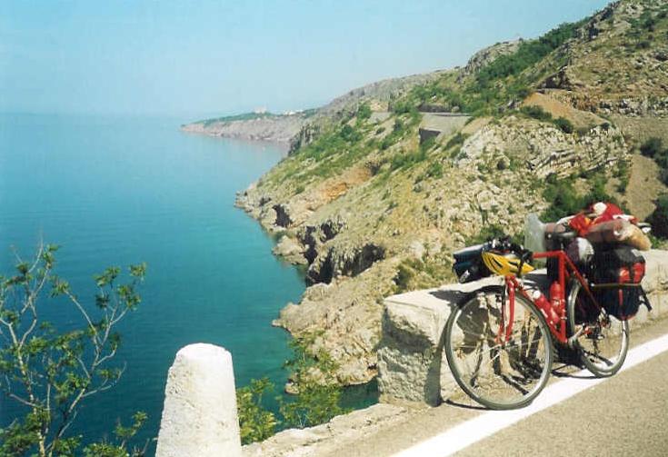
After akku recharging and washing my clothes and having breakfast in the village I left i tat ca. noon to cycle upwards back towards Col de Portalet to enjoy the panorama that I couldn't do last evening because of the darkness. I cycled back 200m heightdifference. The wonderful terrain, the steep mountains, which shape was not the same but more robust than the french Pyrenées, and the lake amazed me. I cycled in a light decending valley to Biescas, where I could see that the edge of the Pyrenées is not so far. After leaving Biescas I pushed the pedals on a calm, quiet ascent to the Ordesa national park. As I turned into the valley and get a sight of the huge and robust, bare rochwalls and mountainsides I had to stop and enjoy the view. It was amazing. A few kilometers later another nice view I had: the tourist village, Torla with the huge mountains behind it. There is 2000m heightdifference between the village and the highest peaks of the mountains.
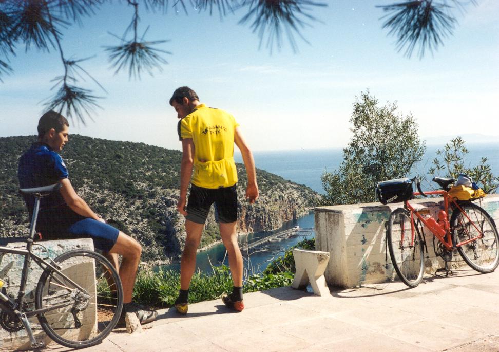
Normal vehicles and bicyclists too are let to go only 4 kms after Torla, there is a stop and controll house. Only the buses of the park are let go in and people can choose to walk in the forests. In the evening I had to cycle more than 40kms I had time only for an 1-2 hour long tour. I walked hurriedly or jogged on a panoramic forest path which few times gave me views to the mountain range northwards from be, but I had to cross the wild stream on a bridge to found a meadow to get a good sight to the belt of mountains at the end of the canyon. Backwards I hurried on the paved road, which was used by the buses too and realized that from there I got more beautiful views to the valley than from the forest path. But it’s true that from the road I could enjoy the views mainly to the end of the canyon and the wild stream deep down between the rocks and I had less views to tghe high - northern - rocks above me.
After supper I had a col ahead of me: the collada Fanlo (1383 m) which is not a spectacular or special climb from West (from where I cycled), but the eastern side…. That is a wonderful panoramic road.
Unfortunatelly after sunset there was’t too much lights, so after a while I could see only the shapes of the mountains, but that was enough to realize, that sure I would have to cycle back a few kilometers to enjoy the panorama by sunlight. Besides the descent wasn't so enjoyable, because it gave me a non waited surprise: the descend was brken by flat kilometers and at a point the road started to go up by 8%, then 10% steepness. I hoped that it wouldn’t last too long, so I pushed the pedals hard, but after 1,5 km I loose my belief and asked shouting to the sky: „-How long would it go up??? This should be a descent!"
That 3 kms long ascent made my angry. Only the fantastic view in the greyness calmed me down. I arrived at the bottom of the descent, at a camping by 11 pm. And the reception was open! (Next day by sunlight I thought that although the french side of the Pyrenées has the legendary ascents, but maybe this part os the Pyrenées is the most beautiful.
25th July, 2010 - 13th day: Puyarruego - 4kms on Coll de fanlo - Puyarruego - Escalona - Ainsa (600 m) - Collado de Foradada (1020 m) - Campo - Castejon de Sos - Benasque (1150 m) - Cerler Ampriu (1912 m) - Benasque - Collado Fadas (1470 m) - Laspaules = 143,84 km + 2958 m szint
Since the start of my tour (airport): 1261,89 km + 26579 m szint
I woke up in time, because before the long day I had to cycle 5kms back towards the Coll de Fanlo to enjoy the panorama by sunlight. The road twisted and turned on a warm mountainside with bushes and with plants which are typical on the Balkan peninsula. From the viewpoint the panorama was unbelievable. That was a very good decision to ascend back. The view started with spanish side of the Cirque de Gavernien mountains, then hude and flowery, rocky robust mountainblocks which are typical Ordesa national park mountains and the last nice special mountain was the Pena Montanesa behind Puyarruego.
This is on eof the most beautiful roads of the Pyrenées / Pirineos.
In the camping I quickly took down my tent, and then I cycled on an almost flat wide road to Ainsa. Sometimesbackwards wonderful huge mountains were behind me. From Ainsa I used a main road to Campo; it was a nice surprise that the road wasn't hilly although the huge mountains were a few kms from it. The 8-9% descent of the Collada Foradada (1020 m) was so wide and straight ahead that I could reford my 73 km/h speed for my videocamera. That wasn't really risky.
Cycling northwards from Campo the gorge remembered me to the Moraca canyon of Crna Gora: nice blue stream down and dry, bushy mountainside on its both sides, than wild and high rockwalls of a canyon. Acame out of the canyon, the next huge mountains showed themselves to me.
I felt myself a little bit tired, which I had to change for struggle against the stong wind that I got into my face in the valley towards Benasque. I cycled to the 1912 m situated Cerler - Ampriu, from where I wanted to cycle above 2000m using a suitable dirt road. As I found a proper hide-away for my packs I took them off and cycle to Cerler-Ampriu (1912 m) only with 3-4 kg weighted pack.
In Benasque I bought some food and then as I turned onto the ascent of Cerler it was funny that with the support of the backwind I could sprint lightly faster for 200 m long on the 10% steep ascent than in the valley cycling against the wind.
During my tour in 2010 (this tour) that was the 1st spanish ascent where I could enjoy signs with useful data for cyclists (steepness, height, km), which are normal and often used in France. The average steepness of the ascending kilometers (there was 2-3 kms downwards) was 7,6%. I liked the Cerler - Ampriu climb: nice view back to the main valley and also ahead to the grassy mountainside, valley and the ski-center.
It was interesting, that on that climb supported by backwind I could push the pedals easier than in the almost flat valley against the wind. Reaching the parking place at the end, I tried to cycle above 2000m, but the dirt roads were too steep, so I gave it up.
Down in the valley because of the backwind I could reach the speed of 60 km/h as I sprinted. After I quickly took my packs onto my bicycle I started the climb of the 10km long 5,6 % steep Coll de Fadas (1470 m) by sunset. Cycling on its upper section there were few views; I could see only the shapes of the mountains, before the darkness. The Moon had so serious light that I had see my shadows on the pavement.
I enjoyed cycling by darkness.
After a short descent, it started to ascend again, but reaching the top I found a good camping in Laspaules. The owner was nice and asked me if my sleeping bag is warm enough. At last he gave my a warm blanket. At 1400m high nights are cold.
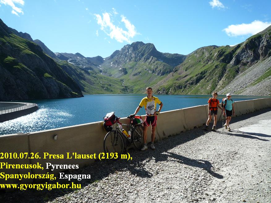
26th July, 2010 - 14th day: Laspaules - Puerto de Espina (1407 m) - Castillo de Tor (camping) - Presa de L’lauset (2193 m) - Castillo - Boi Taüll (2038 m) - Castillo de Tor = 144,4 km + 2606 m
My plan for this day was cycling up on two mountain roads going above 2000m, but neither of them are B.I.Gs. The 1st is the less known Presa de L’lauset (2193 m), about that I found only 3 information sources on the world wide web. This is a lake with a dam to where a very poorly paved road goes up. The other road goes up to the 2038m high situated Boi Taüll ski-center in the next valley. As I know it was Vuelta Espagna mountain stage finish.
As previous day, this morning again I had to struggle against the wind in the Vall del Noguera. I had to fight to reach Bono and a few kms after it turn left onto the mountainside. Based on the diagram of adrianlorente the road going up to the 2193m high situated dam and the lake needs 12,3 kms to ascend the 882 m heightdifference (turning left is at 1311 m), so it is ca. 7% steep. http://www.adrianlorente.com/puertos/datos/HU/llauset.html
After leaving the only village along the road, Aneto, the pavement become worse and after a few kilometers somewhere there is only a thin part to cycle on. I rode a touringbike, and still by this bike the road wasn't enjoyable, only the fantastic views, but downwards by a little bit faster speed it was even worse.
The road is a panoramic road almost from the start to its end: at the beginning there are views to the main valley, then inside to the valley of the lake. I could see the road twisting and turning up on the grassy mountainside to reach the rocky part os it, where the dam is built. The terrain, nature, the scenery was wonderful: I think it is one of the most beautiful ascents (but the worst pavement) of the (spanish) Pyrenées. After going through a ca. 1,5 km long cold tunnel the road arrives at the dam, which is surrounded by rocky mountains, somewhere coloured by snowfields. From the dam there is a nice view back to the valley. By the dam I had a chat with a spanish guy who told me that the road wasn't renovated for more than 30 years. If the quality were better ( on such a bad paved descents the higher speed means more struggling on the bike) I could say: the view compensates for the bad road.
Because of the slow descending and because of the fact that I had to repeat taking photos as my machine was set for pictures with not th ebest resolution, I arrived back at the camping late in the afternoon. I left the camping for visiting Boi Taüll only at half past 7.
I had to cycle 15 kms on a lightly ascending road to start the real climb. The lower part of the ascent showed me nothing extra, but it was going dark. In Taüll resort lights were turned on, from there I had to cycle ¾ hours to the top. Although cycling by darkness isn’t a thing that I enjoy, I changed my mind and thought: with this ascent I would be closer to my main purpose / goal : to collect all of the paved roads going above 2000m in the Pyrenées. I had experiences with cycling by darkness, so no problem. After leaving the last hotels, houses sometimes I was glad to see backwards the lights of the village. The pavement for the last 3 kms was a little bit worse, but not so tragical. By the end of the road there was a barrier and a sign; I put on my warm clothes and after 2 photos I turned back. I have this climb too
In the camping I had supper at noon and beside this I couldn't count with a long night, while based on my plan on the following day I had to cycle 140kms and 2300-2500m heightdifference to Andorra, the mini country that I remember with love. I was elated: on the following day I would arrive in Andorra.
27th July, 2010. - 15th day: Castillo de Tor (camping) - Ainsa - Coll de la Creu Perves (1350 m) - Sentereda - Sort - Coll de Canto (1710 m) - Le Seu Urdell - Andorra la Vella = 139,33 km + 2556 m heightdifference
Since the start of my tour (airport): 1545,62 km + 31731 m heightdifference
I woke up a little bit tired and reflected on, that my daily schedules seemed to be full of adventures, climbs and I needed long days, too long. 130-140kms hard days followed each other, often cycled with carrying panniers and I spent 8-9 hours riding my bicycle. „-I should relax, and ease the days."
BUT: I knew that to achieve my purpose (collecting all of the paved roads going above 2000m in the Pyrenées) I wouldn’t have too much time for rest. I had to make sacrifices to „finish my project". Thinking about the following days it seemed that in Andorra and during the days after then I could have a little bit slacker days , but after …..
I thought about the day and I felt that it would have been success entering Andorra at 8-9 pm.
A true typical Vuelta a’Espagna mountain stage day waited for me: first the Coll de la Creu Perves (1350 m), then a lower one, then before arriving in Andorra, the long Coll del Canto (1725 m), which is a BIG (www.chalenge-big.eu) listed climb. Turning left from the main road I got sight of a wonderful blue, turquoise lake. The climb went up to the saddle in a nice valley, along a stream, then on panoramic mountainside and from the col I enjoyed the nice view: this is a suggested pass.
On the descent I arrived at warmer terrain, with other, drier plants, which are typical for example on the Balkan peninsula, or Provance. After a little bit longer cycling in the valley I chose a short ascent instead of longer valley-cycling. I climbed from Sentereda towards Montcortés, which was also a very good decision: supported climb again!
Minimal traffic, but at frst twisting and turning road, then at a saddle a lake in wonderful landscape and nice panorama behind it. Wild camping is not allowed!
Looking around from the road, the landscape showed that’s Andorra is nearer and nearer; the landscape changed for more and more typical Andorran: redder mountainsides, rocks and dry bushes or bare mountainsides. Arriving at the main valley the air was 32-33 degrees Celsius warm there. I cycled 12kms to Sort, from where the 19km-long mainly 6-7% steep climb was the next enjoyable task. Although I ascended on a main (not minor) road there wasn't much traffic, and I could enjoy the good pavement and panoramic road to mountains. I could see the sharp, specific-shaped mountain, that I saw from the 1st col of the day, Coll de la Creu Perves, in the morning. After having the main part of the climb behind me at 1550m I stopped for a while and ate something and by the lights of the late-afternoon Sun I thought back for the day: I enjoyed that wonderful and good day; I deserved the rest; I rode my bike very well that day. Arriving at the Coll del Canto again with my videocamera in my hands; I could see nice view ahead of me, to NE. I got sight of the Cadi mountain range, that I have memories of my bicycletour in 2007 in the Pyrenées.
The descent made me a little bit angry, while it was a bad descent: too long and broke by long flat sections, when I wanted to go on by 40-50 km/h…. and instead of it I had to push the pedals by 25 km/h. It wasn't a fast descent. From the valley I had only flat and lightly ascending kilometers ahead of me to Andorra. I entered the country by lights at 9:40 pm, but Adorra made me feel elated. I like cycling in Andorra. Andorra la Vella is usually full of tourists and customers, and there are streets full of expensive, modern, lighted, shops. Arriving at the camping I ran against the owner, who showed me where to set up my tent. I fall asleap again after midnight.
28th July, 2010 - 16th day: Andorra la Vella - Els Cortals (2068 m) - Andorra - Arcalis, Vallnord (2225 m) - Andorra la Vella - Grau Roig (2050 m) - Andorra la Vella = 144,02 km + 3483 m
From the start (airport of Nice): 1689,64 km + 35214 m heightdiff.
Finally : „-I can cycle again in Andorra" - I felt happy. Andorra is such a favourite place for me as Nice and its region or the Bonette and Col d’Iseran ascent and naturally the Canary islands. In 2007 I cycled in Andorra one and a half day; then I visited La Rabassa , Coll la Botella, Port de Cabus and Port d’Envalira.
In 2010 three other waited for me to get all of the roads above 2000m there: Els Cortals (2068 m), Arcalis (legendary win of Jan Ullrich in 1997) and Grau Roig a 2-3 km long road to a hotel and ski center, turned right from the ascent of Port d’Envalira.
In the morning I looked round in Andorra la Vella and tried to buy good souvenirs and spent time in a cybercafe to send email to my family and friends (that would have been better by darkness and not by sunshine). I left the capital of Andorra at ca. noon northwards to ascend Els Cortals (2068 m) first. To Encamp the main road was very busy, but after leaving that road the climb is very calm and enjoyable.
The ascent from there began immediatelly with 11% steepness. Later above it gave nice views backwards to Encamp and to the valley and other mountains and at ca. 1700m turns into the valley of Els Cortals. Here the road goes on grassy meadows, a few trees, friendly landscape with views back too. The road ends by the cable car station. I can suggest this ascent.
After rolling back to Andorra la Vella I turned to La Massana which is situated in a side valley, but the traffic is almost the same as in the main valley. I was surprised about it. The real climb of Arcalis began by El Serrat (1455m), the finish ends at 2225 m. The 10km long ascent is generally 6-7% steep and the landscape become truely beautiful above 1800m.
After leaving behind the huge parking place at 1940 m the road starts to twist and turn and it gives great views back / down: beautiful! The finish is by a parking place, where as I was cycling up I thought about Jan Ullrich when he got his legendary win. The paved road ends there, only gravel road goes up higher to the Port de Rat (2363 m), which is situated on the border to Spain.
After some photos and videofilm recording I had to hurry because I had only a few hours before sunset. Reaching Ordino I calculated that I could spare ca. 15 minutes when I skip Coll d’Ordino and roll down to Engordany (1060 m) and cycle from there to Grau Roig (ca. 2050 m - I thought) in the long valley of Envalira.
In the morning I was naive and left the lights by the tent, so I only had light reflecting band with me. I knew the ascent to Encamp from the morning. The climb emained mainly 6% steep after it too, but the traffc wasn't so busy. To Soldeu the villages follow each other, after it I remained on my own by the grey lights.
I thought (maybe I saw it on a picture or somwewhere) that Grau Roig is situated at 2050m, so it was interesting as the main road going to Envalira reached 2100m as I arrived at the junction. After leaving the lighted (by the junction) road I rolled down a little bit in darkness and then ca. 2kms ascent was in front of me to reach the Grau Roig hotel (2060 - 2080 m). Downwards the descent was interesting to Soldeu to where I had to wheel in darkness and rare lights along the road.
After it because of the villages there wasn't anything to be afraid of. After 11pm I walked a looked round in Andorra la Vella by lights and then I fall asleep after half past midnight. I had a great day again!
29th July, 2010 - 17th day: Andorra la Vella - Le Seu d’Urgell - Bellver de Cerdanya - Alp - Puigcerda - Coll de Pal (2070 m) - Puigcerda = 139,51 km + kb 1800 m
From the start (airport of Nice): 1829,15 km + 37014 m
After I slept enough, I walked - cycled, searched proper souvenirs in Andorra la Vella, I wrote an e-mail to my family, to Hungary. As I arrived back at the camping, the owner was nice and told me, that I didn't have to hurry, but I can spend 1-2 hours there with swimming for example and he wouldn’t want me to pay for it. Although it was nice of him, I had to take down my tent and to cycle to Spain, because in the afternoon I wanted to visit Coll de Pal (2070 m), the next pass above 2000m.
Pushing the pedals and going southwards I found most of the shops closed in Andorra, while that morning the french president, Nicolas Sarkozy visited the small country. After eating in Le Seu d’Urgell I was bicycling on a main road to East and felt the effect of the hot weather: after 10kms I felt tired and dumpy. On that section there wasn't any village for 20kms long. As I entered the 1st village I stopped and went into a bakery to buy some delicious baker’s ware. I was surprised very much, when - looking me - a lady walking on the pathway told just the name of favourite cycleracer, the legendary Miguel Indurain. And I didn't wear Banesto bicycletrousers.
The road was built well, I enjoyed that almost there wasn't too much descent after 1-2 kms ascents; so the road ascended almost continuously, broken by flat kilometers.
In the valley there wasn't any view for ca. 20km long. After it I had to look back to see the Cadi mountain range. After Bellver de Cerdanya as I saw the sign which way to choose towards the Cad tunnel, I remembered my bicycletour in 2007, when - to avoid a 60 km longer route - I tried to cycle through the tunnel. I put on a light-reflecting vest and turned my lights on, but 1kms before the end of the tunnel a van of teh operating company stopped and took my bicycle onto the back side of it and took me out of the tunnel.
Barcelona was also signed which was a good feeling to see: „-Although I is only ca 150kms in a straight line, I needed a few days to visit 4 another road going above 2000m and cycle to Barcelona after them. Heading to Puigcerda I decided to choose not the trafficked main road, but a minor road, although it climbed onto a higher hill as high Puigcerda was. I was surprised by a serious Tourist Office before Puigcerda with a lot of prospects to help the tourists: I didn't think that this region is so much visited by tourists. After I quickly set up my tent, I left the camping and cycled towards the Coll de Pal (2070 m). Puigcerda is situated at 1200m, so the heightdifference is only 870 m, but why this col was problematic is that it is paved from South, but from North there is minimum 4-5 km long dirt road to reach the top and I wasn't sure to find the proper road where I could ride my bicycle and I shouldn’t walk next to my bike.
I cycled up to Molina on a steady, average steep, panoramic climb, which I had to change for a paved forestry road. I didn't searched long th ebest road; I found one, that seemed to be good. As I had one and one and another one kilometers behind me, I worried about the direction of the road. It seemed to be the best where it went up, turned, but I hoped to turn right direction: left! At last I reached the level of 1800m, where the road really turned wrong direction, so I said goodbye to it and slowly downhilled and walked with my bike on a short ski-truck. After it I often changed cycling a little bit on dirt path, forest path and walking upwards on paths or ski-trucks. I was angry, but in any case I wanted to reach the col and I knew that no paved road climbed there from North.
At 2100m I arrived at a viewpoint and a sign with map on it, from where I could also see the Coll de Pal (2070 m), where I wanted to go. After walking down a little bit again on a ski-truck I could cycle and 1,5 - 2 kms before the pass I reached a paved road. Oh!!! I arrived at the 2070 m high Coll de Pal at quarter before 10pm, after sunset. It was not too much before darkness. I couldn't really be happy; I was angry, how problematic I could reach the saddle and how serious the situation I had to go down on an other ski-truck direct to Molina. I could see lights far away down in the valley. On my videofilm it can be heard that I said: „Please not to consider me anything (not-normal), I know, that I’m stupid, but now I have to solve tthe task to go down by darkness."
On the steep, rocky ski-truck I walked down carefully and I fortunatelly arrived at Molina and I took delight in cycling again on pavement. What a feeling was to cycle again fast and without watching the path under the tires. From above I could see well the lights ofthe villages of the valley.
30th July, 2010 - 18th day: Puigcerda - Mont Louis (FR) - Lac Bouillouses (2017 m) - Mont Louis - Las Planes / Puigmal (2077 m) - Puigcerda - Collada de Toses (1800 m) - Campdevanol = 177,64 km + 2647 m heightdifference
From the start (airport of Nice): 1996,79 km + 39661 m heightdifference
After waking up at 8:22 and preparing for a local tour I arrived at the french border after cycling only 1km. I pushed the pedals to Mont Louis in the wide, not too steep and trafficked valley that I had known from my bicycletour in 2007. Stopping at a hilltop I could record a film about the totally panorama for my video with the spanish mountains on the south side of the valley with Coma Morera (2205 m) that I visited in 2007, then the side-valley of Puigmal (target for the afternoon) and on the North side the sunlit villages, towns on the mountainside.
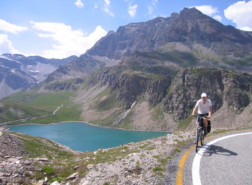
This valley has very good weather (for long time), local clime: in 2007 we experienced that by the lower part of the valley it was true summer with more than 30 degrees Celsius, but on its upper part, towards Col de Matemale the clouds and cold remained for almost the whole day.After cycling through Mont Louis I turned left onto a paved forestry road towards Lac de Bouillouses (2017m), which can be found in a National park. The road starts from the level of 1650m, so the road has little bit more than 350 m heightdifference for 11kms. The road is almost flat for long, it has only two 8-9% steep kilometers. By the start of the road there is a nice camping and then a barrier with a parking place, while only buses (and bicyclists and hikers) are let go to the lake. The paved road goes along a stream; at a small meadow as I saw a family enjoying picnic and playing with their childrens I found it idyllic. That’s an ideal valley for a family for a weekend to rest. Calm and peaceful valley. By the end of the road it was interesting that the dammed lake was situated and the dam wasn't built in a wild, rocky vally, but the landscape was frendly, hilly, grassy: not typical. There were hardly any „hills", where to build the dam. On the meadows horses were grazing and next to the tourist house there were so friendly horses which were caressed by a few child. Walking on the dam I had a chat with a french cyclist guy; he also liked ascents.
After long pedalling and wheeling down in the main valley I turned to South from Orr toards the Puigmal peak. On the internet, world wide web I found not too much informations about it, I could hardly get enough info if the road is paved above 2000m or not. There are only 1 or 2 cycling informations (or photos) on the internet about this climb. Up to now.:-)
The first few km long section gave views to the main valley and the northern mountain range. Unfortunately the asphalt was covered by gravel and didn't stucked, so my speed descreased and I didn't enjoyed cycling on that. It ended after ca. 5kms. By the last kms I could see the inner part of this side-valley and the mountain Puigmal. By ca. 1950m, at a parking place a barrier stopped me with a sign on it. I couldn't understand the french sentences, but a wrod told me: something animal could be dangerous, if I cycle upwards. Cycling ahead after ca. 2kms by a hairpin bend I met with two horses; one of them was a lovely foal. As I walked there a few steps it was funny, when the foal scared so he/she jugged to his/her mom. I went on cycling, but not much far I saw bee-clouds flying by hives so I had to turn back by 2077m. Maybe they could be the dangerous animals.
Supported by backwind on the light descent in the main valley I quickly arrived back at the camping and after a half an hour preparing and taking down my tent I left it and pushed the pedals towards Molina - that I visited last evening - and then the last high pass (Collada de Toses, 1800 m) that I had to cross by my bicycle with panniers on it. On that evening I wanted to cross the last high mountain range that was ahead /in front of me towards Barcelona. To the level of 1450 m I pushed the pedals on a small trafficked road, but after I didn't watch enough and couldn't find a small road going directly up to the pass, so I cycled on the other, longer road through Molina (4kms with 8-12% steepness) to reach the level of 1750m, from where the last few kms were almost flat. The last kilometers were panoramic and I could enjoy the views back towards Puigcerda and I could see the clouds coming northwards covering the pass. I arrived there just at 10 pm, a few minutes before total darkness (again). After putting on warm clothes I started the descent. It was long and too light
Descending and twisted and turned so much that I could go down not so fast and felt the cold for a long time. I run out of my patience and it wasn't simple to find a camping, but at last I saw sign showing campings not far from there….
But it was much far, than expected: I had to cycle another 5kms to find the camping, where I set up my tent by midnight.
After a wonderful day I could finish my day again very badly, as previous day.
31th July, 2010 - 19th day: Capdevanol - Ripoll - Camprodon - Vallter 2000 - Ripoll - wheat meadow before Vic: 146,12 km + 1668 m heightdiffference
From the start (airport of Nice): 2152,91 km + 41329 m heightdiffference
My last climb that I needed to have cycled the full / total collection of the paved roads above 2000m in the Pyrenées meant a ca. 100 km long tour from Ripoll, that’s why after taking down my tent and buying enough food I hid my panniers again (4th occassion during my tour) at the end of the town. I can’t find reason why to carry my 26 kg weighted packs when cycle to the ascent and back on the same road.
Surprisingly the sky was mainly covered by middle thick clouds and I worried about some rain and not so warm weather, so I carried some warm clothes with me.
I was bicycling on a flat or minimally ascending road between small mountains (I couldn't see any high mountains next to the valley); higher mountains came into sight as I reached Camprodon (980 m), a small, lovely town with a great romanesque bridge, which was built at the beginning of the 13th century. In the spanish Pyrenées / Pirineos in the previous day I didn't meet too many cyclists, so it was a nice surprise to see bicycling groups in the valley.
I enjoyed the centre of Camprodon with the tourists and with two nice girls playing with their photo-machine by the stream shore next to the famous bridge. Few ducks were swimming on the water.
Pushing the pedals towards Setcases I often saw tourists, but after this village the traffic decreased: only those ascended by their cars who were interested in hiking by Vallter.
Meantime the Sun came out and could sometimes shine through the broken clouds fyling by the level of 2000m. Sunshine and flying clouds changed each other.
The ascent under the level of 1800m was an average climb without too much beauty to show. By the Collet de Xoriguera (1880 m) there was a viewpoint with view back to the valley and ahead towards Vallter. I had some snack by a wooden desk with great panorama. During bicycling upwards I enjoyed very much pushing the pedals between small clouds.
By the last few kilometers with serpentines I met with a few hikers and calm cows. The ascent finished by the parking place of the ski-center. I MANAGED to collect by bicycle ALL OF TE PAVED ASCENTS GOING ABOVE 2000m. I was very happy. I enjoyed that I cycled not onlythe well known ascents, but other beautiful ones, like Presa L’lauset, Puigmal valley or Els Cortals, Lac Bouillouses, etc.
Up to now I could found the climbs of the Pyrenées by visiting several websites, and there was no one (1) piece of website to have all of them. This success meant not „competing" with the hungarian cyclotourers, but with the best foreign cyclotourer-cycloclimbers. Better to say: not competing but achieving to belong to the best cycloclimber-tourers. My goal in the Alps is the same: to get into the best cyclotourers-cycloclimbers of the Alps (those who not cycle with a very light bike, but sometimes with panniers and visit a lot of climbs). To reach to have all of the paved roads going above 2000m in the Alps I need one normal bicycletour next summer and a shorter one, but I don’t want finish it in 2011 in every case.
I enjoyed the fast descent, but not much the long and almost flat valley afterwards. By Ripoll I found my packs without any problems. In the following hours I wanted to cycle as far as I could towards Barcelona, because my aim for the following day was to have enough time - after cycling - for an evening swim, bathe.
By the south part of Ripoll the trafficked main road went between storehouses,
and after a while became 2*2 lane wide road. I hadn’t seen signs warning cyclist not to pedal there so I went on pushing the pedals there, although I thought it’s not a good thing. But I knew that’s the fastest and shortest road towards Barcelona in spite of minor roads. After a while I saw signs which prohibitted cyccling there on the road that entered / joined the main road, but I enjoyed cycle fast there, so I remained there.
After 20kms I was stopped by a policecar. The ploiceman could speak english, and at first was sullen, but we could speak the problem well. I told him that I hadn’t seen signs for cyclists not to cycle there and later I asked him to tell me which are th ebest minor roads towards Barcelona. He sugegsted me a very good minor road just next to the main road after Vic for the following day.
Because of the lenght of the speach I arrived at the surrounding of Vic not much before darkness and I didn't have spirit for searching for a camping so I decided wild camping at a plough-land without any hesitation. I could do that while I didn't have to charge akku.
1st August, 2010. - 20th day: plough-land before Vic - Vic - Tona - Colle Furmic (1145 m) - Tona - Centelles - Caldes - Polinyá - Sabadell - Rubi - Molins - Lobregat = 164,74 km + 1527 m heightdifference
From the start (airport of Nice): 2317,65 km + 42856 m
I woke up satisfied on my last day of my bicycle tour. I thought I have ca 100kms left to Barcelona, so I was hesitating if I could climb a B.I.G. listed ascent starting just from the road I would have to cycle. Colle Formic (1145 m) meant a 30km long, ca. 3-hour-long extra tour with stops and photos and time for hiding the packs. I wanted to spend time for it by the case I could swim in the sea in the evening.
Leaving Vic I pushed the pedals on a minor road next to the main road that was suggested by the policeman. I crossed the Pyrenées; the high mountains were behind me. I left Tone towards Colle Formic riding my bike without heavy panniers. After a few kms I was overcame by a bicyclist riding a light bike, which made me fresher. I followed him and arriving at the steeper part I accelerated and left him behind. I used the climb as a training ascent 1 month before the Ötztaler radmarathon, my dream, that I wanted to fulfill at the end of August.
In contrast with the Pyrenées on Colle Formic I met with more cyclists: it could have been a training road. I had views to non-average mountains.
After rolling back I took the panniers onto my bike, had eaten something and then ascended the last mountainrange of the tour. From the level of 782 m the descent was a long one with flat sections and short ascents, so after I while I was angry. I had the first „Hurray-feeling" by a hairpin-bend of the descent: I got sight of the agglomeration of Barcelona. Ca. 1 hours later as I saw the sky-crapers of Barcelona and I felt deep gladness. I ARRIVED !!
Theoretically I arrived, but I didn't believed how much time and effort, patience I need to cross the agglomeration using a lot of main roads, crossing highways, seeing stores, factories, fast trains, etc. Before and after Sabadell the road went up and down from hills: up 60-80-100 meter heightdifferences. Before Rubi I had to climb ca. 100meters onto a hill, but that was the last. From there I arrived at the river shore, where I was cycling more than 2 hours to the beach. I was pushing the pedals through the unpleasant part of the agglomeration. In contrast of my printed map I had to cycle more than I saw on the map.
By the Coll Formic I thought by ca. 7 pm I would swim in the sea, but really at that time I was far away from the beach. The more and more additional kilometers I had to cycle between the villages, the more and more I felt me angry. It seemed as the beach were dragged away from me. And the other thing: 15kms the airport there was no sign about it! How could it be happened ? t last only 5 kms before the airport I could see the first sign about it. I needed another 8kms of cycling through the trafficked roads of the tourist-towns few kms fro the beach to arrive at the road going next to the beach, where I needed time to find the right camping, while I found there closed camping place. OH!!! I FINISHED IT!
For hours large clouds arrived above the beach (no clouds above Barcelona), that decreased my motivation, mood to run into the sea. Although I couldn't enjoy swimming by sunset, but after setting up my tent I walked into the sea. As the airplanes were taking off just above me, and as I thought about the nearly 3 weeks of experiences, great adventures started by Mont Ventoux and later by Canal du Midi and though about the climbed complete collection of roads going above 2000m in the Pyrenées I felt catharsis: I WAS HAPPY!
After my tour in 2007, when I crossed the Pyrenées from the Atlantic to the Mediterranean sea, in 2010 I crossed this lovely mountain range crosswise with zig-zagging somewhere.
In the series of my bicycletours in 2011 I will return to the Alps, where I will enter the home straight of collecting all of the paved roads going above 2000m. The collection can be completed not later than 2012. It would be great to have less than 10 climbs (going above 2000m) left by the end of 2011.
Summarizing the tour:
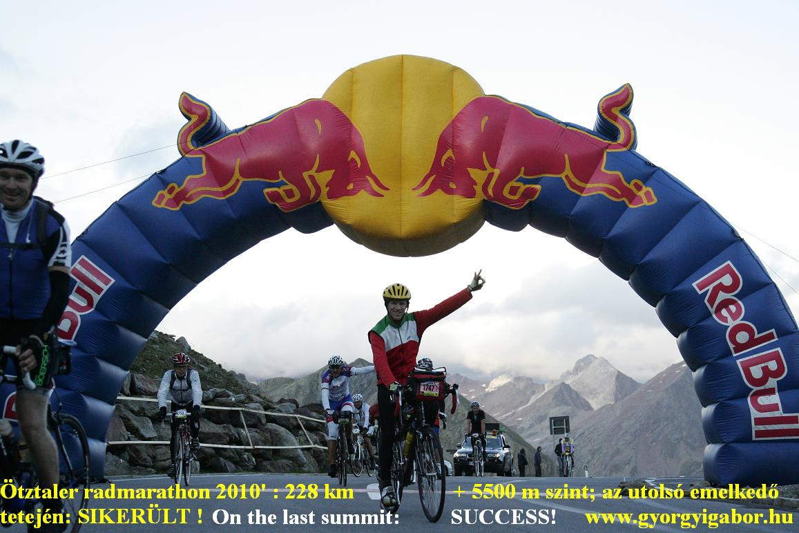
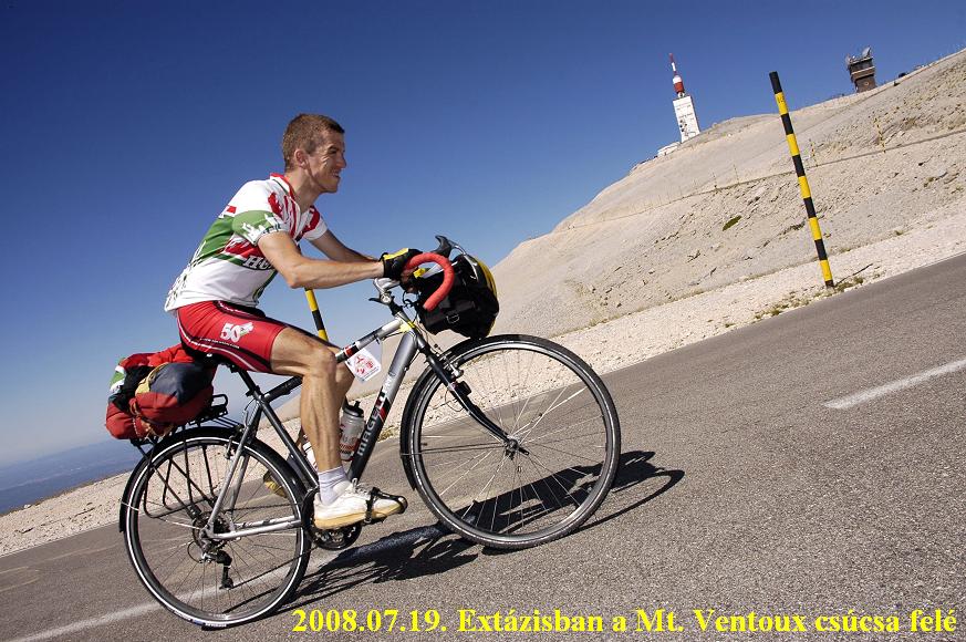
Despite of the 34 degrees Celsius on the 3rd day I succeeded in cycling 4 times up to the Mont Ventoux on 4 route in a day: it was a huge, fantastic feeling, experience and I took very good videofilm about the day. I enjoyed that I could „organise „ the day so that I didn't have to hurry, but I had enought time to enjoy every time, every scene, view, kilometer, etc. I could enjoy every moment of the day - as I planned, wanted. To the end of the day I reached a new heightdifference record of mine: 6126 m - by my touringbike : the same strong and not light bike on which I crossed through the Pyrenees in the following 2 weeks.
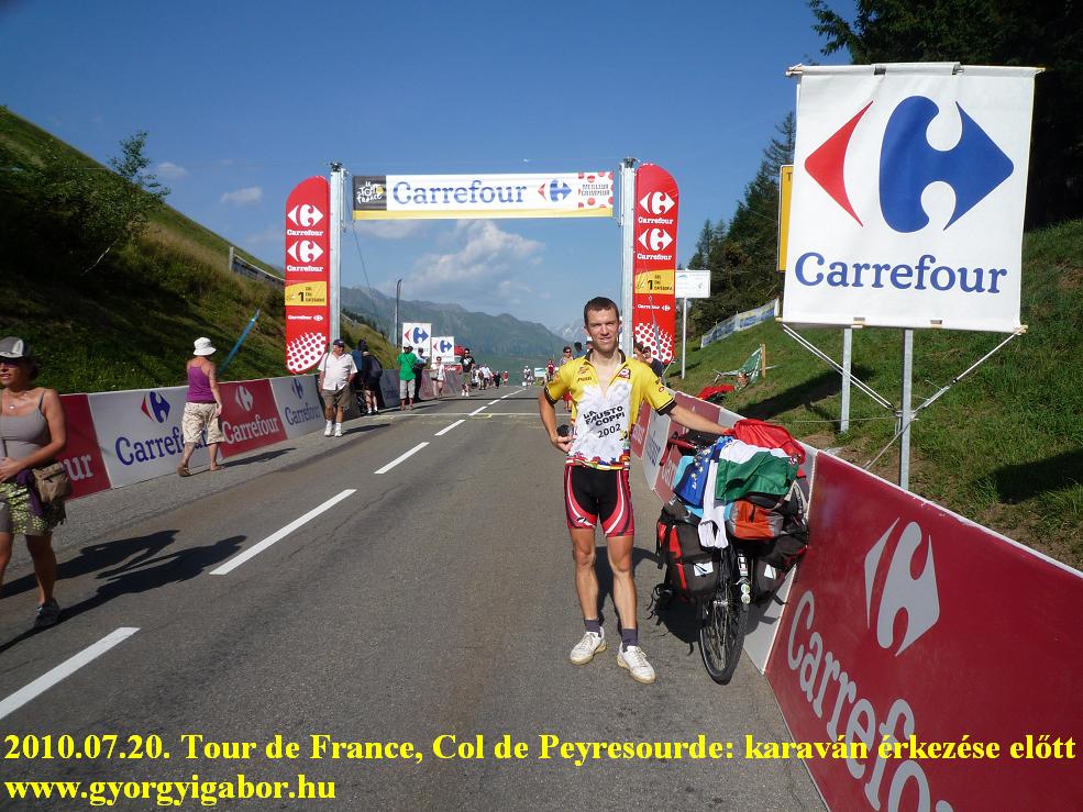
In the Pyrenees 2 times I lived throught the Tour de France feeling + experience with sunshine and blue sky: the caravane, the fuss and the fast cycling away /by of the racers. The 3rd day was unfortunately rainy, so I skipped cycling on the ascent of the Tourmalet, but was waiting for the peloton in Lus St Saveur.
In Spain the huge and steep, almost vertical rockwalls, mountainmassifs fastinated my very much, so as I experienced this for minimum a half day I thought and now I think: although it can be found not on the terrain of the mythical Tour de France mountain stage routes, but maybe this ca. 100 km wide region (from the line of the col de Portalet to the line of Cerler and Rio Esera) is the most beautiful in the Pyrenées. Because of my determination to collecting all of the paved roads going above 2000m in the Pyrenées on the spanish side I finished almost all of my days by darkness: I didn't want to hurry but take enough photos, videofilm, stopping when I wanted to enjoy the beauty, etc. Although those days weren’t easy and I didn't have enough time to having rest, but in longer term I think my decision was good: with the successful tour and collecting I feel happier than with a little bit more rest time but with l- for example minus 2 climbs above 2000m. With this way my will-power got it’s result: I cycled of the known paved roads above 2000m - based on minimum 5-6 list of climbs. On the spanish side one of my favourite was the very-very poorly paved road to the 2193m high situated Presa L’lauset: a dam and a wonderful lake. This road was told to be renovated last time 35 years ago.
In Andorra I felt again very well, I enjoyed this small country very much: again I had good weather and saw beautiful mountains and roads.
Although the statictics is not the 1st priority and I’m not interested in them before and during the tour, some data:
During the bicycletour (from the airport of Nice to the airport of Barcelona, in 19-20 days) I cycled 2297 kms + 42866 m heightdifference, which is the 2nd mountainous tour of the last 7 tours which are at a higher level of cycling on mountains then before 2004. After the 9 of year 2004, the 13 of year 2005, the 10 of the year 2006, the 7 of the 2007, 11 of my tour in 2008 and 12-13 of the 2009, during my tour in 2010 with Mont Ventoux and 2 weeks in the Pyrenées I cycled up to 11 Hors categorie climbs of the Tour de France and Vuelta a’Espagna. They are: Mont Ventoux (1909 m) 3 times, Pla d’Adet (1680 m), Cirque Troumouse (2108 m), Luz Ardiden (1720 m), Col d’Aubisque (1709 m), Cerler (1911 m - HC in 2005, 2007), Presa L’lauset (2193 m), Andorra Arcalis (2225 m) and Vallter (2150 m).
Data from:
http://home.tiscali.nl/edwinsel/races_pro_history.htm
http://www.adrianlorente.com/puertos/datos/HU/llauset.html
http://www.steephill.tv/2009/vuelta-a-espana/
At last informations, numbers without any comment: (I was very motivated to reach this) A list about the well known and most known bicycling websites, climb collections of the Pyrenees (and not only) with the numbers of their listed climbs above 2000m in the Pyrenees:
Cyclingcols.com: 21 pc (?): maybe only the Presa L’lauset is missing from the list, but by an e-mail I got the answer, that the owner didn't cycled all of the climbs that are listed (for example Puigmal).


 Pyrenées: bicycletour (1st part)
  My passes


