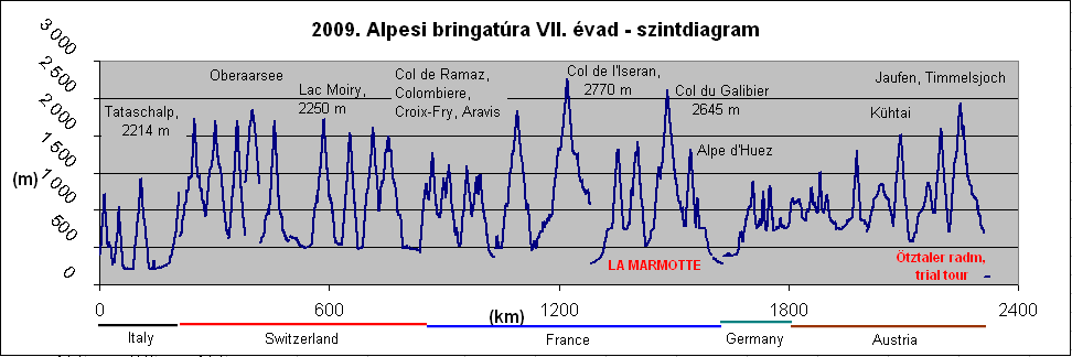
In the summer of 2009 I cycled in the Alps again. I organized my tour around 3 milestones: I registered for participating in the 2nd hardest well known bicycle-marathon of Europe, the traditional and famous La Marmotte (174 kms + 4900m heightdiff. with the Col du Glandon, Col du Galibier and at last Alpe d’Huez.).
The other event was the international BIG meeting in South Bayern (Germany) with other bicycletourers and at last a trial tour along the route of the Ötztaler radmarathon. A participation on that event in the following year became one of my dreams in my life. This bicyclemarathon is 228kms long with 5200m heightdiff. Beside these I visited another nice and memorable climbs, mainly in France, the country of the Tour de France.
Saturday, 21st June, 2009 - 1st day: Varese – Campo del Fiori – Passo Cuvignone – Verbania – Feriolo = 79,3 km + 1788 m heightdifference
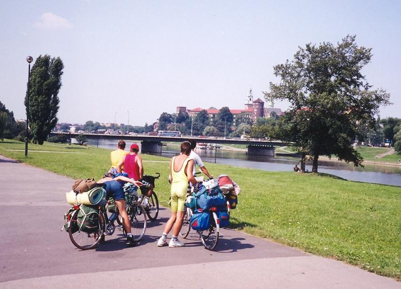
After a few hour long sleepeing at the airport and the fast airflight I arrived at Bergamo at half past 7 am. The town has a pleasand mood, it is lovely and calm. I had a little time to the start of the train so I used this time for climbing up to the castle from where I had beautiful 270 degrees view from the edge of the Alps to the Po plain terrain. I had change train at Milano, but I realized it too late, so I lost there almost an hour. Between the train change I had to cycle to an other train station. Arriving At Varese I started there my bicycletour, immediately with ascending up to the 1217m high Campo dei Fiori (BIG:)that had really steep kilometers on its last few kilometers, above ca. 1000m.
Because of this steep end Ont he lower part of the climb I searched to find place to hide my heavy packs behind bushes, and I could found. The last kilometers – after the parking place were 14-16% steep. From the top there is view to the snowy alpine peaks and lakes. Few of the mountains are situated on the swiss border to where I cycled on the following day.
I can suggest this climb to visit. The road to Passo Cuvignone (1036 m) went in a quiet forest for a long time. After a left turn a guy joined me on a light bike and although I had 24 kg luggage he didn’t want to go ahead and left me, but we talked together paralell with pushing the pedals. After 1-2 kms of 11% steepness I thought it would be lighter to cycle alone, but I was pride to say: I have to spare with my strength. So with much effort I arrived the top with the guy, Stefano to whom I talked much about the BIG organisation and why I like it. THis climb was also losted between the 1000 climbs of BIG. Why ? Because it’s hard and is one of the main test ascent of Ivan Basso.
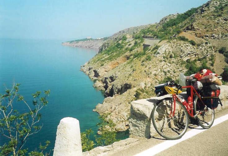
Unfortunately there was no view from the saddle and almost no view from the descent, though this climb is just next to the Lago Maggiore. AFter ferrying through the lake I called Mauro Repetti, a member of the BIG with whom I planned a half day long tour on the following day.. While he slept at an other place I built up my tent in the Canca d’Oro camping just at the shore of the Lago Maggiore. I was happy to go to sleep not too late.
Monday, 22nd June, 2009 – 2nd day: Feriolo – Mottarone (1455 m) – Feriolo – Domodossola – Gabi – CAR – Brig – Visp = 128,2 km + 2524 m heightdifference
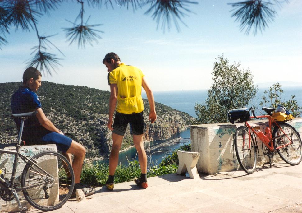
In the morning I met with Mauro with pleasure by the feet of the Mottarone climb (1455 m), at Stresa. We cycled up on a calm, sometimes panoramic road with fresh air. I enjoyed meeting again with Mauro and enjoying the nature meanwhile. I told him : this is, what I like: cycling on fantastic terrain in a good companionship. Mauro’s legs were in a good shape; has was ready for the Granfondo Pantani take place in a week. My top form was planned to „arrive” in 2-3 weeks time. Reqaching the upper section, there was a road which went around the peak; from most part of it we could enjoy great panorama: first to West and to the Lago d’Orta,
then to NW to the snowy peaks and to Monte Rosa, on the other side to the Lago Maggiore. After going down we said good bye to each other (and we knew we would meet again in South Germany 2 weeeks later) and then I returned back to the camping to pack up.
I went on cycling with 25 kg packs on my bike towards Domodossola and Switzerland. Although on the Lago Maggiore light East or SE wind was blowing, after ca. 20kms from NW headwind made me struggle. It made me tired and slower. Before the Simlponpass ascent I visited Domodossola, but as I knew there was no choice for travelling by a bus or train travel to Switzerland. The first part of the climb wasn’t steep, I saw lily growing wild along the road and at the height of 1000m I saw a 4*7 m portion snow remaining from the winter.
I was 1200m high when the sun went down by the high mountains, so I decided to sleep in Simplon village and not to cycle in dark. With this plan in my mind I was surprised by the houses of Gabi (the same name as my nickname) when a van stopped and an old pair asked me if they could take me to Switzerland. The heaven sent them: they were just going to Visp, my destination for that day, so I thanked their help. We arrived at Visp at half past 10. I was a little bit sad about skipping cycling Simplonpass, but that was not so serious problem, because I already ascended this pass: in 2006 I cycled up on the swiss side.
Tuesday, 23th June, 2009. – 3rd day: Visp – Tatschalp (2240 m) – Stalden - Mattmarksee (2197 m) – Visp = 130,16 km + 3065 m heightdifference
I woke up for cloudy weather, but when I started to the first climb, Tatschalp it was shining brightly. The ascent to Tatsch (this is the last village to where cars can be used towards Zermatt) was varieble: sometimes middle steep, sometimes is had flat kilometers. Sometimes there was bicyclepath built for the cyclists. In Tatsch the air was cold: the thermometer showed 15 degrees Celsius. About the paved climb going above 2000m I read at www.quaeldich.de (http://www.quaeldich.de/paesse/taeschalp/ ) .
The steepness started just at the start of the narrow ascent, and during its 7 km the steepness of the kilometers was: 7% - 11,1% - 10,7% - 11,5% - 10,7% - 7,3% - 8,7% - 12,6%. On the first half I could enjoy the views to the valley, to the snowy peaks going above 4000m and
not too sharp pictures to Zermatt. Unfortunately the Matterhorn, one of the most beautiful mountains of the wold couldn’t be seen. The last 3 kms went in the Tatsch valley and the road ended by a few houses at 2240 m. Looking up in the valley, that was no miracle that is was so snoewy, while the valley’s direction was towards the 4633m high Monte Rosa.
In the afternoon I cycled in the next valley to Saas Fee and then to the 2197m high situated Mattmarksee another lake used for electricity production. Unfortunately in Saas Fee it started raining lightly which made my mood be wrong, but after the afternoon I can say: I had fortune that it was not cold but warm rain. In spite of the rain I wasn’t cold; I could push the pedals to the top dressed in short cycletrousers. The road was almost „untrafficked”, but the nature was not so superb, it was average, but I had to add: because of the clouds I couldn’t see the peaks of the mountains. Along the last kilometer I met with snow few times, once the snowwall was 2m high.
By the lake-level there was snowfield next to it, so I had to walk in snow to the lake. The kilometer was straight and steep, so it would be ideal for a bicyclerace finish. Rolling back to the camping coming out of the clouds I had a wonderful view to the mountains shined by orange sunset lights.
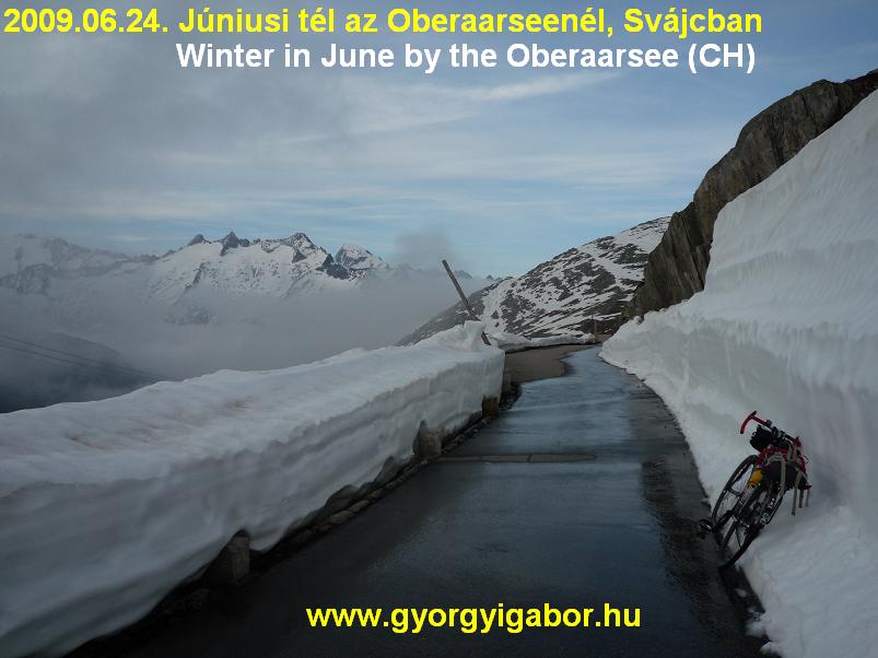
Wednesday, 24th JUne, 2009. – 4th day: Visp – TRAIN – Susten – Leuk - Alpe Galm (2231 m) – Susten – TRAIN - Oberwald – Grimselpass (2165 m) – Oberaarsee előtti tető (2400 m) – Grimselpass – Oberwald – TRAIN – Visp =79,6 km + 2757 m szint
After a few sms with two hungarian bicycletourer my program for the the afternoon was cycling to Gletsch, Grimselpass (2165 m) and Oberaarsee (another BIG listed place). For the morning I organized a half-day long tour up to the 2231 m high situated Alpe Galm with an average 8,4% steep climb with 1607 m heightdifference not far from Visp. The ascent is just opposite to the Matterhorn and is hardly known, although it is wonderful. It is the 45th hardest climb of Europe based of the climbbybike.com database.
The lower section of the climb goes between or next to grape plantation or through meadows. After going through two small panoramic villages and 4-5 km long 12-16% steep part it arrives to the Alpe Galm. On the last few kilometers we can see the mountain range from the Mont Blanc to the mountains east from the Monte Rosa. I suggest to visit this climb!
In the afternoon I traveleld by train to Oberwald (where I had already cycled in 2006) from where I spinned the pedals to Gletsch hearing good music in my ears. During the climb as I came out from a bend I saw the same as few times before: the steep mountainwall of the Grimselpass coming clouds from there. We ate some food for having enough energy and then I left Gletsch 5-10 minutes earalier then the guy because I had to hurry to catch the train in the evening.
We agreed that we would meet each other towards Oberaarsee. I almost cycled as I were on timetrail race; I rarely stopped for taking photos, sometimes took the videofilm during cycling along snowwalls. The last kilometer went in fog, cloud and the half km long saddle of the Grimselpass was in serious cloud. As the road went between high snowwalls in cloud it was just in the middle of the winter. I was hard to find the narrow road to the Oberaarsee but I had fortune with it: it was a private road and was cleaned of the snow. I bypassed the barrier and started the ascent between snowwalls in fog. After 2kms I went out from the clouds and can see the views to the snows peaks as it were February. I had never cycled in such a snowy terrain; I often went through water flowing through the road.
I often checked the time, but I took enough photo and videofilm. Backwards to the Grimselpass I rolled down carefully, but after then I speeded, hurried down madly. I had no time to find the cap in the pack, so I put nylonsack onto my head, under the helmet. At last I arrived at the train station just 3 minutes before the train came. On the train I enjoyed the warm air very much.
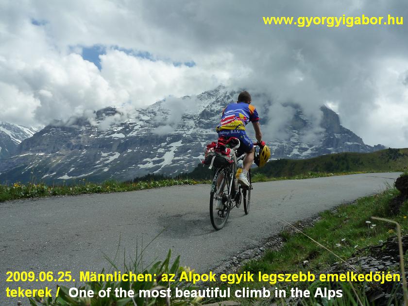
Thursday, 25th June, 2009. – 5th day: Interlaken – Mannlichen (2229 m) – Interlaken + TRAIN - Visp – Bramois = 123,3 km + 1902 m heightdifference
Mannlichen (2229 m) was the climb that I planned for the morning was really the last paved col of te Alps for me and was told by Jerry Nilson to be one of the most wonderful ones of the Alps. As it was situated far for a 1 day long tour I used travelling by train to and back from Interlaken. In Switzerland travelling by train is expensive.
From Visp I arrived to Interlaken in an hour. That’s a place which wasn’t unnown for me, because I cycled here in 2001. After leaving Interlaken I first cycled on lishtly ascending road, than variable climb to the ca. 1000m high situated Grindelwald which is a beautiful town with 4000m high peaks next to it. The three famous peaks (Eiger, Mönch, Jungfrau) is between the well known sightseeings of Switzerland. Rack railway goes up to the 3454 m high situated Jungfraujoch. After eating I started the Mannlichen climb in nice, sunny weeather. I had no infos about it’s steepness, but thought it shoudl be average 9% steep.
First the road went, twisted upwards between farms, houses on meadows, as a cablacar went up not far from the road. Signs showed the bikers which road to choose to Mannlichen.
The right road cannot be missed. The local bus goes up to ca. 1400m, than there was no traffic: only the nature, a few walker, hiker and me… and cows. Enjoying the views to the snowy famous north wall of teh Eiger I didn’t feel hard the ascent, although it was 9-10% steep. Unfortunately above 1700m clouds arrived, I rarely got sunshine. The last few kilometers were sometimes 14-16% steep, there I had to struggle. On the way up as I was just taking videoflm, I met with german bikers. After they saw the small hungarian flag on my bike noticed: „-From Hungary! Nice!”
The paved road ended by the 2229 m high situated cable-car station from where a steep gravel road went up to the Mannlichen peak (2343 m). Because it started raining lightly I didn’t cycled there. From the viewpoint there was view down to the Lauternbrunnen valley. After recording the panorama to the valley and the trio of the snowy mountains and the twisting road down, I started going down immediately; I wanted to catch a train arriving at Visp in time.
I often checked the time, but after Grindelwald as I had to face with headwind it seemed to be I shouldn’t have to hurry: it was in vain. I accepted to have nearly 1 hour in Interlaken.
After travelling through the long Lötschberg tunnel and I arrived at the camp, I realized I had no time for an other climb up to 2000m (Weritzalp), but then I had to change the camping. I packed up and then cycled ca. 40kms down, West towards Sion. After a while I found a good bicycleroad along the Rhone river on which I could cycle with music in my ears and ithout disturbed by cars. At last I found a camping in Bramois, next to Sion.
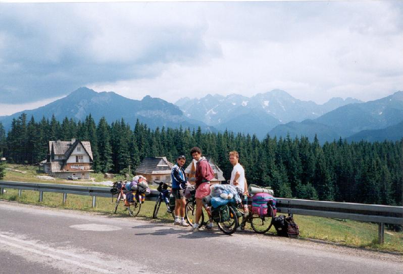
Friday, 26th June, 2009 – 6th day: Bramois - Lac Moiry (2249 m) – Bramois – Thyon (2095 m) – Bramois = 141,6 km + 3672 m heightdiff.
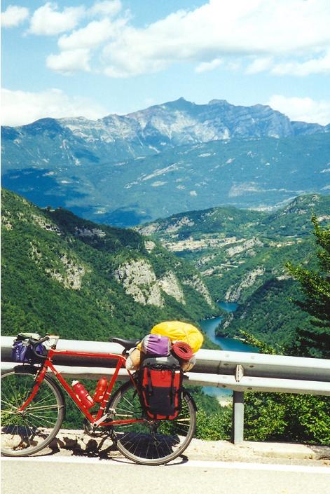
I woke up for my last hard swiss day.I waited it, but otherwise I wanted to be over it and after it to have lighter, not so long days. After enough sleeping, purchase (every sign is french in this region) and breakfast I started the tour with 15kms along the Rhone on the bicyclepath. After this warming up I had to bypass Sierre and then turned right to the climb from the height of 565 m to the 2249m high situated Lac Moiry which is one of the highest paved road of Wallis / Valais.
Halfway unfortunately I had rain, but after Vissoie I could enjoy light sunshine; the geranium flower alog the serpentine road to the nice Grimentz village too. I was impressed by the terrain, nature and Grimentz too: nice touristic village! By the parking place at the end of the village there was a short flat section, but after it, the climb started with 10% steepness. AFter a few kilometers in the forest I could see the dam. Above 1900m the road went on bare meadows, sometimes with flowers on it. After going through a cold tunnel in the last 10% steep kilometer, I arrived at the lake. The lake situated between snowy peaks greeted me with cold air, so I didn’t spent there too much time, I turned back: I had another long climb ( Thyon for that day.
Because of the lack of many views and the bad weather there was no reason to stop too often, so I climbed it almost as I were training. I tried to delay the stop, so I had the first rest after ascending 700 m heightdifference. Looking down from the height of 1300m, many places were raining: above the opposite mountainrange dark clouds were „sitting”. Somewhere thunder was hitting, but at the place where I cycled I didn’t have to fear. Yet.
Above 1700m I got the rain too and I was afraid of the thing that my clothes that I took out to be dried will be wet in the rain. The air became so cold that I had to put on some clothes, but I didn’t put on my long trousers, because I thought I had only 1 one with me and I had to keep it dry for the descent. The strength of my soul and will-power helped me to arrive the top in such a cold weather. I wasn’t happy, I was angry, but I was happy to did it. This climb had no worth for me: almost no views, boring ascent and bad weather. I had fortune with my clothes, because I found my raintrousers so I could go down putting on warm clothes.
Opposite adventure was for me Alpe Galm, 2 days ago. This BIG climb should changed for that ! ?
After a little bit slow cycling in Sion I arrived back to the camping at 11 pm.
(Till the end of the day I cycled 682 kms + 15708 m heightdifference in 6 days.)
Saturday, 27th June, 2009 – 7th day : Bramois - Gr Dixence (2141 m) – Arolla (2006 m) – Bramois = 112,06 km + 2817 m heightdiff.
The two BIG listed climb of my last swiss day is situated in valleys which are next to each other, so I had only one and a half climb for that day. The ascent to Grand Dixence (2141 m) became beautiful from its half. From there the nature was calm, breathing with flowers, fir trees, views to the dam and the last kms of serpentines. I had seen before that the last kilometers would be cool with the many hairpin bends. The interesting thing of this climb is that the road goes only to a hotel and cable car station by the feet of the dam and if one wants to go up he could choose between walking or cable-car. A sign shows that bicyclists cannot use the road further / behind the barrier which is – I think – the ownership of the power plant. There is a museum in the cable car stationand opposite to it on a sign I could read about the waild animals of the surroundings.
After descending at the halfway point of the valley I turned into the valley of Arolla which started with few flat kms. It was followed by 4-5kms normal steep kilometers to be changed to flat again.
I wasn’t happy of this long climb, becasue it was only for wasting time; mainly downwards. Looking ahead I could see that ahead and higher in the valley it was raining. I was angry a little bit: There is no day without rain ?
Fortunately the rain clouds were moving, so when – after eating something – I arrived there I had no rain, but sunshine and wet road. After a turn in the last touristic village, the last section of the ascent went into a valley surrounded by 3600-3800m high mountains somewhere glaciers and ski courses on it. Arolla was my 78-79th BIG climb of me above 2000m ( I don’t know if Col de la Madeleine is just 2000m or lower), of the 152 climbed ones and that was my 100th different peak, col above 2000m that I reached by bicycle. And totally that was the 123th occasion when I cycled above 2000m. I just wanted to start rolling down, when it started raining lghtly again. At last I had not too much rain downwards.
Sunday, 28th June, 2009 – 8th day: Bramois – Martigny – TRAIN – Monthey – Pas Morgins (1371 m) – Chatel – Col de Bassachaus (1778 m) – Morzine – Montriond, camp = 87,2 km + 1700 m heightdiff.
I spent the morning calmly: I had a little time for writing my notes and I changed the front anc back out tires on my bike, because the back was seriously used. I was aftarid of having puncture on that maybe ont he following week because of the heavy packs on the bike. I thought I would have calm and pleasant cycling in the Rhone valley to Martigny and then to Morzine (France), but I became angry because of the strong wind after Sion. Sometimes I cycled on a bicyclepath, buta s it became gravel I had to cycle between fruit plantations and in strong wind. Although from Monthey (where I last cycled in 2001) I had to face with the Pas de Morgins (1369 m – BIG), I felt happiness because the forest and the mountain sheltered me of the wind. On the steep part of the climb a guy on a light bike told me that: „I can hardly imagine how cycling could be with such a huge pack on a climb like tthat.”
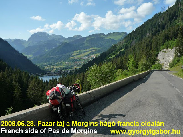
The swiss side of the Pas de Morgins was sometimes nice, as the village Morgins too, but I was really amazed by the frech side: friendly mountains, forests, a village with full of flowers and a lake naxt to it and ideal sunlights. As I entered France, the country of the Tour de France my mood changed better and I felt again: „I arrived to the country where I usually had beautiful experiences and after it everything would happen well.”
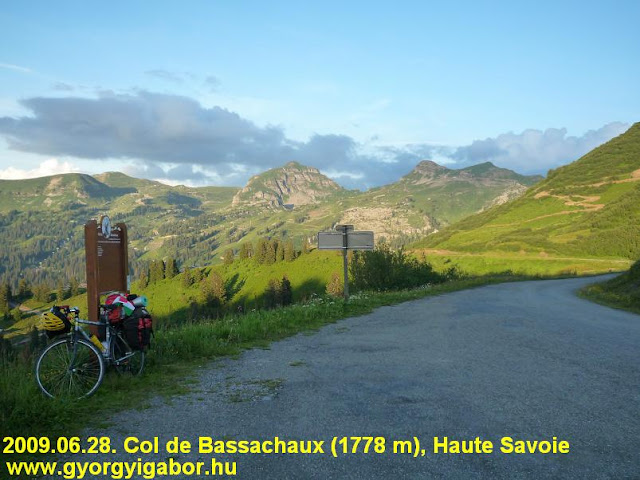
Chatel was a nice, friendly, sunny and flowery village which was full with mountainbikers because of an event. After leaving Chatel I cycled in a calm, deep valley to SW to shorted paved but minimum 20 km longer route to Morzine. I knew that I could climb the 1778 m high Col de Bassachaux (1783 m) on paved road and had to roll down only 2kms on unpaved road to Les Lindarets to have paved road under my bike again. From the cable car station, the foot of the climb the steepness became 9-11% and the road was calm, not too wide: it seemed like a forestry road. I found a good rhythm of cycling so I enjoyed the calm, partly sunny forest while smelling of fir trees. In France everything seemed better ! I felt me very well. The scenery was friendly with 2000-2500m not too sharp, but grassy mountains. Unfortunately I hadn’t printed the detailled map about the col, and while I chose not the good route after a while I realized the unpaved road is just a path and is too steep downwards, so I had to walk next to my bike. It was very very steep and I was afraid (and very angry!) if the road went wrong way. Fortunately the path joined a better unpaved road on which I could reach Les Lindarets but because of the sunset I had no time to reach Avoriaz, a BIG summit. I was angry because of that. On the cold descent I reached Morzine in dark and built up my tent in the next village.
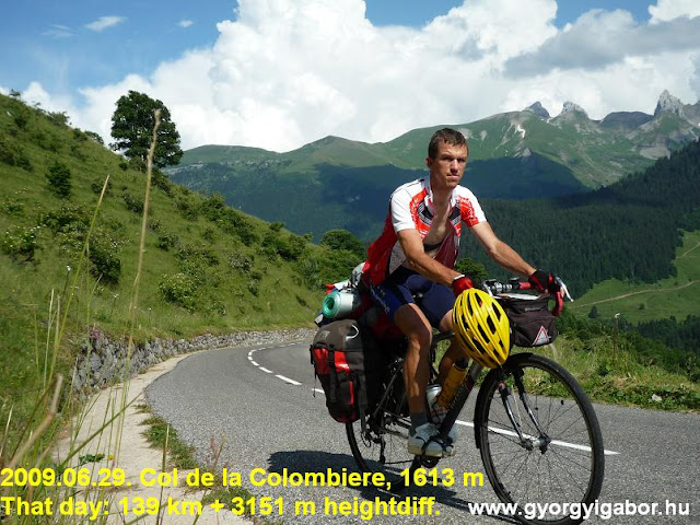
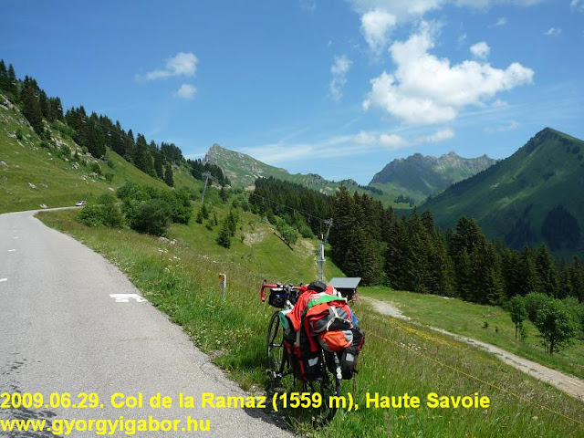
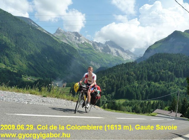
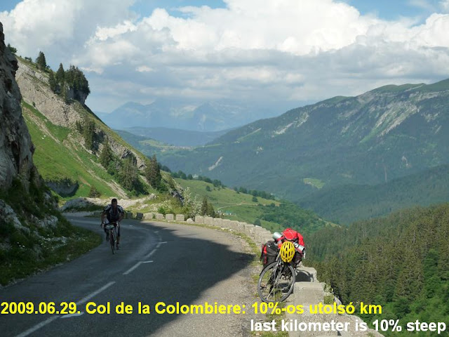
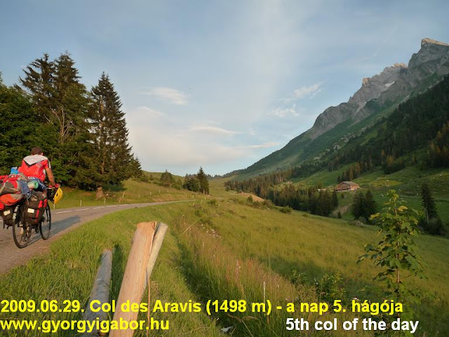
29th June, 2009, Monday – 9th day: Col d’Encrenaz, Ramaz, Colombiere, Croix Fry, Aravis -> Albertville = 139 km + 3151 m heightdiff.
I waited for this day with great expectations and it happened as I „had dreamed”. The route went through a few middle high mountains which are famous because of the Tour de France. The most famous is the Colombiere on which I never cycled and otherwise I planned to breack my one day climbed heightdifference record (3004 m) with heavy luggage / pack. The 1st col was the Col d’Encrenaz (BIG) with its totally 3kms long 10-11% steep parts. It is a very calm and nice, friendly ascent. The next one, the Ramaz (BIG) showed me it’s hardness just after the junction with a 3km long 10-11% steep section. So the day started with hard climbs and the Colombiere (BIG) is known to be hard too.
Cycling towards Cluses on a short flat part an american guy on a light bike jumped out behind me and sprinted for a while, but after 1 km he stopped because of something. On the next 4-5% steep climb I just overcame a guy with normal speed, when the american came again. This time I followed him to the top (1 km), when – with my packed bicycle I sprinted and defeated him with words to him: „-That’s all?” I hate guys who show how fast and strong they are on a light bicycle, but they compare themselves or they race against heavy packed bicyclists. I showed that a bicycletourer can also be strong.
Cluses greeted me with warm weather; I ate the sandwiches and cakes in a good shadow and enjoyed the sitting and the rest. The first half of the Col de la Colombiere (1617 m) was disinterested and went 7-8,5% steep in a forest. Halfway, at Le Reposoir I met at second time with an american girl who was touring partner of those american guys one of which I defeated. They trained also for La Marmotte. The 2nd half of the ascent gave more nice views and was steeper: 8,5-10%. On the top I surprised myself with small travel-gifts and icecream; I enjoyed sitting a little bit and enjoying the views. 2 guys came to me and were surprised and amazed by the preformance I had: cycle up onto such a hard cols with so heavy luggages on the bike! After the descent I climbed on a partly known road the Col de la Croix-Fry (1467 m) (BIG) which is a calm ascent and the col itself gaves also nice views. The last col of the day was the Col des Aravis (1498 m) that I reached (1st I visited it in 2006) just before sunset.
On the descent because of road works I should have to change the road for a hilly one for a while, but I didn’t feel mood for it, so I cycled through the closed road…. First it was not so complicated to go through a barrier and fence, but next time it wasn’t a simple job to go over the fence with my bicycle. Maybe it wasn’t a good decision. The day ended with fortune as I found an ideal camping just next to the bicyclepath at Albertville. After a very memorable day my new one-day heightdifference record with packs is: 3151 m.
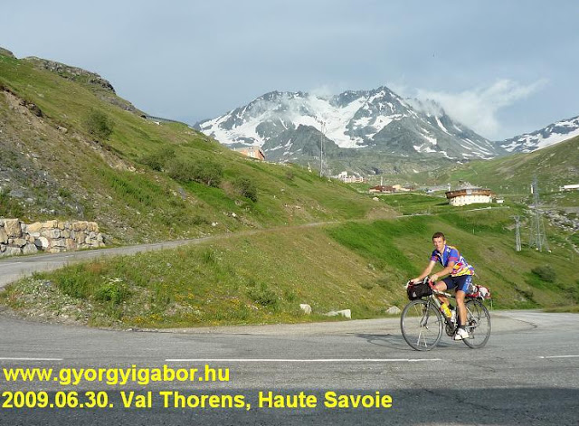
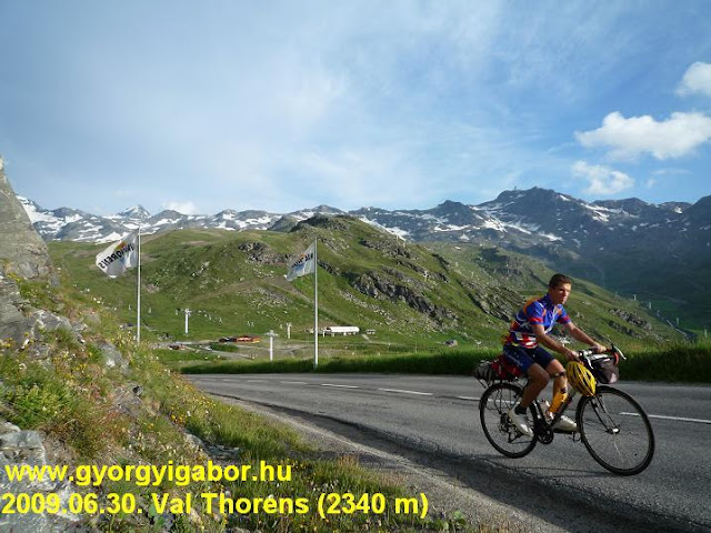
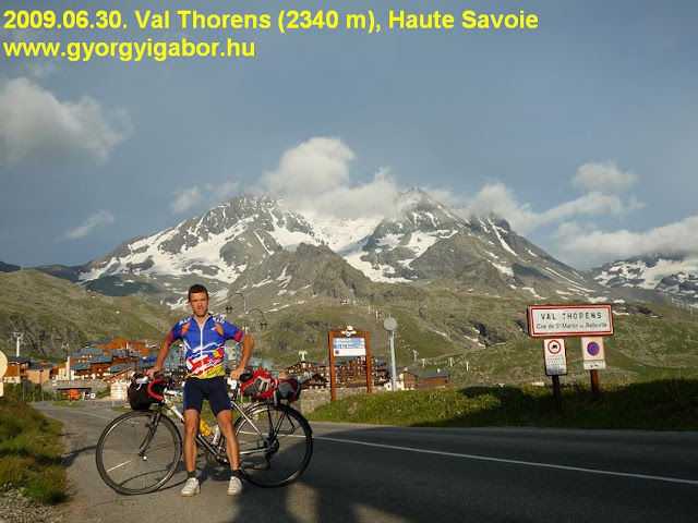
Tuesday, 30th June, 2009 – 10th day: Albertville – TRAIN – Moutiers – Brides les Bains – Moutiers – Val Thorens (2340 m) – Brides les Bains= 102,23 km + 2251 m heightdiff.
This day I felt the impact of the previous hard day. I didn’t feel the freshness, I felt me pressed and less motivated to cycling 2 serious climbs. So I felt enough to cycle only 1 long climb above the level of 2000m. I preferred the higher: Val Thorens (2340 m) instead of the just 2000m high Courchevel which was known for me because of the Tour finish in 1997 when my favourite Ullrich cycled up with Richard Virenque who had a very strong day that day with attacking on the 1st climb: Col du Glandon, then Madeleine and at last they ascended Courchevel. What a day they had !
Val Thorens was also a Tour de France finish. The lower section was uninterested, in the middle of the climb when I came out from the forest I had a little rain and in the 1800m high situated Les Menuires there was a lot of buildings and few shops but all was closed so I coudn’t get food and water. I was very angry about it: how could it be: a town with a lot of hotels, shops with plces for ca 10000 people but summertime everything is closed. I had little bit to drink, I had to spare with it. The scenery showed its beauty only above 1900m, when I can get sight of the snowy and rocky mountains around the finish: val Thorens. Nice mountains! The road had long straight sections and only a few hairpin bends. I really enjoyed the last ca. 6-7 kms. At the end I was surprised that in Val Thorens, at 2340m I could found a church, „ecole” = school, playground and bowling course, etc.
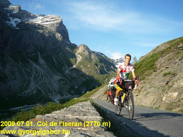
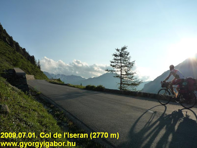
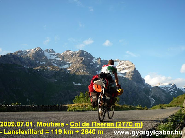
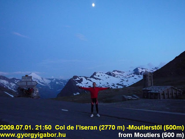
1st July, 2009. Wednesday: Brides les Bains – Bourg St Maurice – Col d’Iseran – Lanslevillard = 119 kms + 2640 m heightdiff.
I waited for this day very much as Col de l’Iseran (2270 m) is one of my 3 favourite climbs, so I dropped my tent zealously. In 2004 I cycled from south and had rain above 2500m. I felt cold, but after leaving the rain the Sun came out and the nature became wonderful in the „afterrain” sunshine. Now I arrived back to feel nostalgy and cycle it from north – and again with packed bicycle.
Already in the morning two typical french thing made me happy: a sign / table showed that cars should have keep 1,5 meter wide distance while overtaking the bicyclists. The other was that on an „almost highroad” the cyclists were taken into a tunnel on a separated section at the side of the road and after the tunnel the road went through a viaduct! Tunnel and viaduct for bicyclists also and not 1-2 kms longer secondary road.
I enjoyed having rest at Bourg St Maurice with walking the the center and licking icecream. I found a superb T-shirt with a drawing on it: mountains on it with ca. 10 famous cols in France: I cycled each of them, so I bought it with happiness.
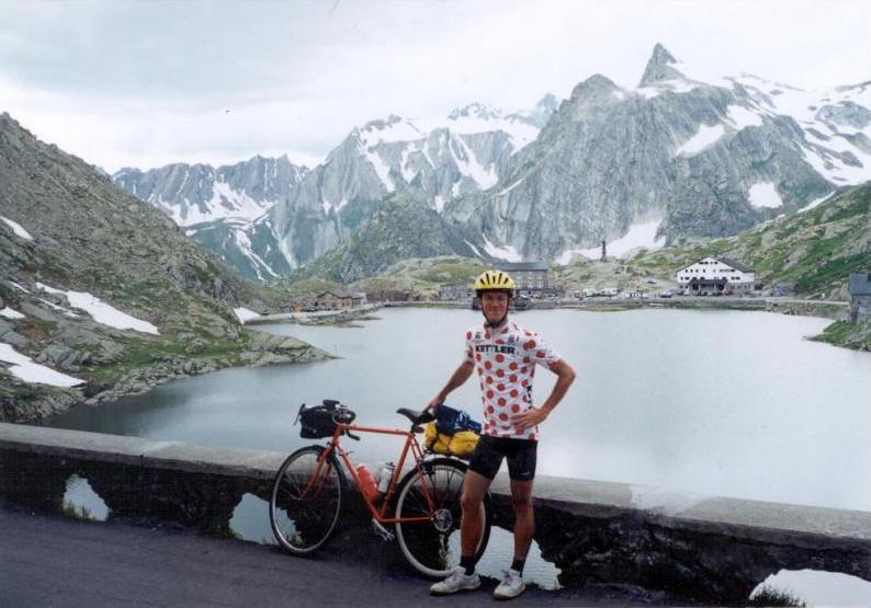
The lower section of the Iseran ascent was trafficked. Above 1200m I got rain and thunder, but fortunatelly as I spent a little time at Val d’Isere it went away and the sunshine arrived. So I had just the same wonderful weather on the upper 1000m heightdifference as in 2004, when I fell in love with this col. So Col d’Iseran became one of my favourite col forever! I climbed it under blue sky, bright sunshine with views to snowy high peaks and with very less traffic. I took a lot of photos, video so the time passed by. I reached the 2770m high top not much after sunset, so I descended under moonlight after putting on warm clothes and cap. I slept at a good camping of Lanslevillard.
Thursday, 2nd July, 2009. – 12th day: Lanslevillard – Modane – TRAIN - Grenoble – Bourg d’Oisans = 87,6 km + 596 m heightdifference
I took down my tent under sunny, blue sky. I was impressed my the lovely village, Lanslevillard: a place where I have to come back. Nice place and good cols around it! As I felt pain in my wrist and I had only 2 days left to the La Marmotte, the famous bicycle marathon I gave up cycling up the 2645 m high Col du Galibier with heavy packs on my bike. Between Modane and Grenoble I travelled by train and tried to take rest. Fortunately from Grenoble I had backwind towards Bourg d’Oisans the start of La Marmotte, where I had reserved place in the camping which was almost full with cyclists. My place was next to the camp which became the terrain of the camping with mobile shower and wc.
The number of the participants of the Marmotte wasn’t a problem for me, but the thing that they couldn’t shup up their jowl at half past 11 pm. made me very angry. Shouting from my tent I tried to ask for quiet. That could be my last long night before the La Marmotte when I hoped to sleep enough.
Friday, 3rd July, 2009. – 13th day: Bourg d’Oisans – Alpe d’Huez (registration) – Bourg d’Oisans = 30,7 km + 1071 m heightdifference
After 7 and a half hour sleeping I woke up little bit sullen and worry: if I can’t sleep enough next night I had enough fitness in vain: the successful finish will be questionable. Lesson: next time accomodation in a house and not in camping.
After washing my clothes, breakfast and shopping I met with the other 3 hungarian guys (Dani, Andris and Balázs) who also participated in the Marmotte. We cycled up to Alpe d’Huez together to registrate and get the starting package, start number, etc. We took photos and video. I enjoyed cycling together, but there were a lot of cars: huge number of cyclists used cars to go up instead of cycling. I have serious opinion about them: they were lazy and thought that with sparing that 1 climb they could be stronger next day. I thought: Are you so weak or does it matter if the guy gets the 3526th place or the 3448th place ?
In Alpe d’Huez we found a few cycling exhibitor where we could buy energy bars too and there were good cycling jerseys too. Instead of them I bought good T-shirts with Tour de France col sor La Marmotte on it.
After arriving back the camp ( in the last straight section I reached 74 km/h speed) I controlled the brakes, get out small mechanical things from my mechanical set and choose the necessary things for the following day. In the evening I sent message to Hungary from an internet cafe in the camping. In the evening I joined the hungarian guys to eat pasta together. I went to sleep at 11 pm: at this time most of the people in the camping were sleeping. Hm.. It seemed if they want they can be quiet in time.
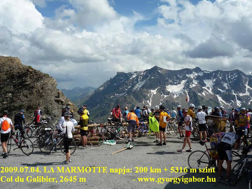
Saturday, 4th July, 2009 : LA MARMOTTE: Bourg d’Oisans – Col du Glandon / St Michel – Col du Telegraphe – Col du Galibier (2645 m) – Bourg d’Oisans - Alpe d’Huez – Bourg d’Oisans – 400m up – Bourg d’Oisans camp = 200 kms + 5316 m heightdiff.
I was happy to be able to sleep to 5:45 am, when everybody was preparing seriously. Because of my startnumber I was enrolled for the group starting at 7:50, so I had a lot of time.
In the mass as I were waiting for the start and taking out my videocamera everybody looked at me such face when I arrived there with my 13,5 kg weighted touringbike with mudguard and luggage rack on it. Rolling through the center a local music group were playing there and people greeted us with clapping their hands. In the first 7kms I hurried forward, and then arriving at the dam I thought: „Now comes the „Dance”! The climb started ! On steeper parts everybody was panting. The ascent of Col du Glandon became beautiful after leaving the forest and arriving at the next blue lake: green forest, coloured cyclists and blue sky. I took photos often from the saddle, sometimes I took video as we were pushing the pedals and I was holding the handle-bars with one hand.
I arrived at the Col 15 minutes later as I planned and I had this delay to the finish. I spent more than 15 minutes by the fresh- and checkpoint. Everybody was filling their mouth with a lot of food (sandwich, dried apricots, fruitsugar, banane) with a hurry no matter if something fell down. I ate a Powerbar too. For a short time I sat down onto the grass to feel the rest. We were warned for the danger of the descent by signs; a few years ago a cyclist died here. I was also overtaken by a few people, but there were a few whose descending was dangerous; I mean : cycling from behind to ahead of them..
In the main valley towards St Michael not a few cyclist were pedalling alone. It was strange that most of the people of the last 15% of the participants were cycling not too fast, so I (alone) overtook a few people and felt going on and leaving them behind. I didn’ want to join a group with a speed of 3 km/s less.
The next col, the Telegraphe was going up continuously in a forest with an average 6-8% steepness, except the first 2 kms. It’s true that it was in the last 15% of the „peloton”, but with my own speed I countinuously overcame the cyclists. As there were no views, after 2-3kms I started to count them to make the climb more interesting: I overtook ca. 30 of them / km. After a while I started to turn my head and watch their bikes: how serious and expensice bike they use and is not enough for a good climb. The best of the world: Pinarello, Bianchi, Colnago, Trek, Wilier, Look, etc.
They were 1000-2000 EUR worth or a few more (?).my bike was 200 EUR 4 years ago and with it the cheapest (and heaviest : 13,5 kg + 2,5 kg pack) in the peloton. I think too many people think that it’s better to buy a light bike instead of train more on mountains. I like to overtook such guys! The muscles count more than the weight of the bike – I hope.
At the top I stopped only for 2-3 minutes to took a few photos. Towards the Galibier the clouds were getting dark and in Valloire it started raining.
The rain caught me just at a good time, while I waited for the end of the heavy rain I could eat by the refreshment point: sandwiches, banana, dried fruit, orange (it is given against acidification of muscles.) and 2 Powerbar. Only a few were cycling ahead, most of the cyclists were waiting. After a few photos I left the place and cycled 15 minutes yet in the rain hearing the voices of the thunders. The weather became wonderful just at the just place:
I could enjoy the beauty of the snowy peaks, serpentines and the line of the coloured bicyclists under sunshine. There I overcame less people then before; I was also overtaken by a few guys while I stopped for taking photos or videofilm.
In the last km of the climb of Col du Galibier (2645 m) at 2-3 places professional photographers were doing their job to sell it after the Marmotte for a good price. I reached the top at 4:15 pm. and spent there 9 minutes: the panorama was wonderful with ideal lights. The best was the southern view: serpentine with the bikers and behind them the very snowy La Meije. On the descent serious headwind caused bad surprise, so I used the lee of a tall cyclist who hurried ahead of me after I had overtaken him because of his not enough speed.
On the descent with our speed we overtook about 6-8 cyclists and had a group. 6 pm was the last time when people had the opportunity to turn up to Alpe d’Huez with remaining in the registered finishers. I arrived there at 5.42 pm and ate so much to be in time. We had to face with this legendary, 8,5% steep ascent with 1120 m heightdifference. What a finish!
In the first 3-4 kms I stopped a few times because of photos and taking good videos (a few of the bikers were walking with his bikes), later I pushed the pedals continuously. Arriving at the village of Alpe d’Huez – as I saw it by a cyclist in front of me – I took out my videocamera and were recording the clapping people which made them louder and activer: They started to clap louder and shouted to me (and to the camera): „-Come on, come on! You can do it! ”
Maybe my bike and the thing that I had to use one arm to hold the handle-bars made them do this. I enjoyed it very much and I smiled. That’s everybody would like to feel sometimes in the life. In the last km – that was not so steep – I felt well so I started to lift my speed and almost sprinted into the finish enjoying the applause of a few people along the road. My time for the 174kms + 4900m heightdifference was 11:36 but the net time was only 9:28. AFter it I spent ca 1 hours in the finish area with eating, staying in the row and calling my family by phone.
Because I felt well and I was not „far” from my heightdifference-record, after descending I turned back and started to climb another 400m to break my record. If I started it earlier I could do more, but so I finished my day with the climbed 5316 m heightdifference. In 2010 I’ll try to rise it.
(I finished as 4853th and 500 another arrived behind me and ca. 2000 cound’t reach the finish.)
Bramois – Barrage de la Gr Dixence (2141 m) - Arolla (2006 m) – Bramois
112,06 km
6:55:42 (109,41)
15,8
2817 m
3257 kcal
Júni. 28.
Bramois Sion – Pas de Morgins (1367 m) - Chatel – Colle Bassachaux (1778 m) – Les Lindarets – Montriond
87,2 km
?? (83,3 km)
?
1700 m
3141 kcal
Júni. 29.
Montriond – Col d’Encrenaz – Col de Ramaz (1619 m) - Taninges – Cluses – Col de la Colombiere (1618 m) - Le Grand Bornand – Col de la Croix-Fry (1467 m) – Col des Aravis (1498 m) - Flumet - Albertville
139,05 km
9:19:34 (139,05)
14,9
3151 m
4289 kcal
Júni. 30.
Albertville – VONAT – Moutiers – Brides le Bains – Val Thorens (2340 m) – Brides les Bains
102,23 km
6:05:36 (93,23)
15,3
2251 m
2577 kcal
Júli. 1.
Brides les Bains – Bourg St Maurice – Col d’Iseran (2770 m) - Lanslevillard
Bourd d’Oisans – Alpe d’Huez (1860 m) – Bourg d’Oisans
30,7 km
2:03:54
14,8
1071 m
1062 kcal
Júli. 4.
LA MARMOTTE : Bourg d’Oisans – Col du Glandon (1924 m) - St Jean – Col du telegraphe – Col du Galibier (2645 m) – Bourg d’Oisans – Alpe d’Huez (1860 m) – Bourg d’Oisans – 400m fel és vissza


 www.gyorgyigabor.hu