Györgyi Gábor: Most wonderful climbs of the Alps, Pyrenées / Pirineos & canary islands, Andalucia
GYÖRGYI GÁBOR
- The most wonderful, beautiful climbs by bicycle -
- Collection of the most enjoyable climbs in the Alps, Pyrenées, Canary islands & Andalucia -
After cycling all of the paved ascents of the Alps, Pyrenées, Canary islands going above 2000 m and after cycling more than 32000-33000 kms in these mountain ranges, it is obvious to make a compilation about the most wonderful and enjoyable climbs. The compilation is now – for few weeks long – a living collection; I may add few other ones, as I look through again. It’s hard task to choose the most wonderful ones of more hundreds of ascents, because the selection is influenced by the weather I had, the lights, the traffic, etc. Of course the list is totally subjective. When I consider a climb as one of my favourites it’s obvious that the landscape should be great, the road could be interesting and maybe twisty, exciting, but for me it’s important that it should be calm without too much, noisy and smelly traffic. So in other words the list can be called as the list of climbs with the most enjoyable adventures.
Read about them with pleasure !
(The first three climbs are really the 3 most wonderful and enjoyable ones for me, but I haven’t ranked the remaining ones, only listed them following each other. )
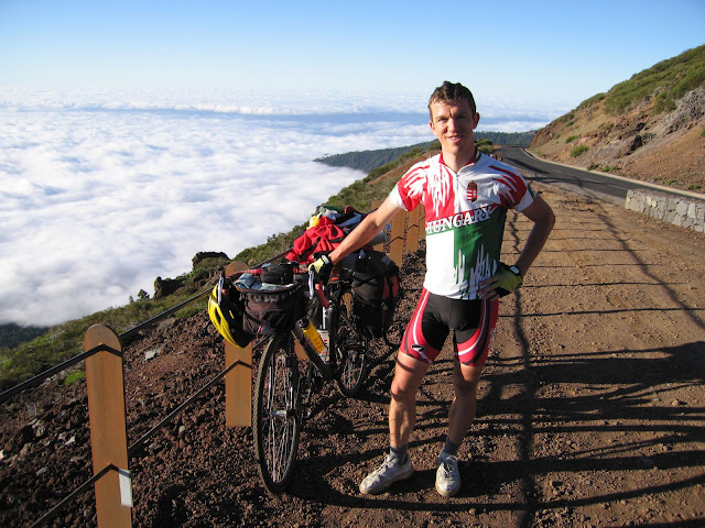
Roque de los Muchachos (2426 m)
Location: Canary islands, La Palma
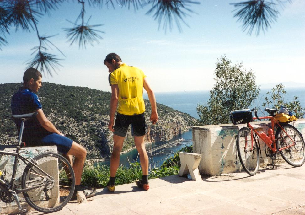
Introduction: Guidebooks consider La Palma the steepest islands of the world. Because of its climate Canary islands it is called as the islands of the forever spring. Comparing the islands, La Palma has the most plants on its surface and the island itself is very volcanic. The main mountain was an old volcano and a smaller one’s last eruption happened ioin the year of 1971 ! For me Roque de los Muchachos is the most wonderful of those ca. 180 different climbs going above 2000m, that I did because it gives the most items, things that a nature-lover wish to experience while cycling a wonderful ascent: challenging heightdifference and steepness, variable and interesting plants for 2-3 climates, beautiful views, panorama to the ocean and Tenerife, the clouds and the volcanic island and the experience of cycling above the clouds. There are 2 ascents to the mountain, to the observatories - built not far from the top -: starting from Santa Cruz de la Palma, at the beach and the other starts at the other side of the islands, at ca. 1000 m. The steepness of both roads is about 7-8%, without tha flat, panormanic section of the eastern climb on the ridge.
While the traffic is minimal, cycling the wonderful ascents can give unforgettable memories !
Introduction: The highest mountain of Spain, the 3718 m high Teide is located in Tenerife. Its plateau is situated at the height of 2200-2300 m and has wonderful rockshapes, volcanis lava flows, etc. Five different roads ascends to the plateau from the oceanlevel, I cycled 4 of them: two and a half upwards and I descended the fourth one in darkness. The Northern one, which goes through La Esperanza forest and national park, is said to be the most wonderful, interesting one. Cycling through it I could almost feel the breath of the trees. After leaving the forest behind there are great views to the both sides of the island and to the ocean and to the neighbour islands: Gran Canaria, La Palma, El Hierro. Above ca. 1500m the experience of cycling above the clouds could cause happiness. Reaching the plateau we can enjoy the volcano and the lava fields along the road instead of the panorama to the ocean.
If I compare what I fent on Roque de los Muchachos (La Palma) and while I was cycling up to Teide plateau the less traffic and tourists, the silence, tranquility and more green plants caused why my favourite place ascent is Roque de los MUchachos and Teide is only the 2nd.
Introduction: Pico Veleta is Europe’s highest finishing paved ascent. The peak is 3394-3396 m high, but the paved road ends at ca. 3250 m and only a dirt road reaches the top. Standing ont he top the Mediterranean sea, the town along the beach and slightly Africa can be seen. The climb starts not far from Granada and the whole ascent means nearly 2700 m heightdifference. The landscape is really beautiful above ca. 1700m – I think. The quality of the pavement decreases seriously after leaving the barrier behind at 2550 m: somewhere is has potholes or for few dozens of meters the pavement is over and the cyclist has to ride on dirt road. Because of the serious heightdifference and the strong wind that can happen at the top I suggest to carry some warm clothes.
Difficulty of the ascent: The length means the difficulty of the climb, and the strong wind above 2500 m. The ascent’s average steepness is 6-8% and is never steeper than 10%.
How to get there: The ascent starts not far from Granada, which is located in South Spain; the nearest airport can be found in Malaga and Almeria.
I introduce the following wonderful, very enjoyable climbs without ranking them (!!!):
Colle Nivolet (2612 m)
Location: North-West Italy, little bit South from the Mont Blanc mountain group
Introduction: Colle Nivolet (2612 m) in the Alps’ 7th highest paved pass. It is paved only from one direction (East), coming from the other direction after a while only a path is available to walk upwards. Because of this situation part of the motorbikers doen’t visit it, so it’s another enjoyable ascent with beautiful landscape above 1600 m. It is a cul-de-sac road and the top is 60kms away from the valley’s entrance, Cuorgne (414 m), that is another reason for the not too many bikers. The landscape become interesting and attractive after coming out from the 3kms long tunnel by Ceresole Reale (1612 m): there are mountain meadows, then serpentines ascending on the steep, wild mountainside and the last reasons, why I though it should be between the most wondeerful ascents are: mountain lakes, waterfalls and the serpentines of the last few kilometers with the background of high snowy peaks.
Although it is a long ascent I don’t consider it as a hard climb, because it ascends from step by step with light section between the harder parts.
Profile of the climbs: from Locana (40,5 km)
Grossglocknerút / Grossglockner Hochalpenstrasse / High alpine road (2505 – 2571 m)
Location: Austria, High Tauern (National Park)
Introduction: The Grossglockner high alpine road surely one of the Alps’ most wonderful roads or maybe the most wonderful, but for me unfortunately not the most enjoyable, because of the too much traffic. It is a real hard climb: starting from South, at heiligenblut (1301 m), or North, at Ferleiten (1145 m), both sides are continuously 10% steep. Its maximum steepness is 16%. The ascent goes through the High Tauern National Park and good, well established parking places often wait for the tourists, there are enough restaurants, buffets, and besides almost every moments there are minimum 3000 m high, snowy peaks in our views and we could see great waterfalls, few mountain lakes along the road. Th ere are 3-4 very attractive and motivating point for the cyclists that should be visited:
Franz Josefs Höhe (2367 m): It is a panoramic cul-de-sac road, which starts at 1871 m and goes just opposite to the Grossglockner peak (3798 m). At its end there is a large parking place, a lot of tourists taking photos, recording videos and the dirty Parterze glacier can be seen.
Hochtor: the pass itself (2505 m) – the road goes through a tunnel to the other side.
Fuschertörl: famous, wonderful viewpoint, ca. 6kms North from the Hochtor tunnel.
Edelweissspitze (2571 m): the highest point of the alpine road with full panorama (to a lot of peaks above 3000m). The viewpoint can be reached on ca 2kms long, 10% steep, cobblestones road.
2012-ben 14 év után tértem rá vissza, hogy videóval is megörökítsem.
Because most of the cyclists know only the often visited and well-known ascents and to avoid critics, I won’t introduce now a hardly known beautiiful ascent to appear ahead the legend, Stelvio, but later sometimes I will earlier intruduce less-known climbs than often visited ones.
Passo dello Stelvio / Stilfser Joch (2760 m)
Location: North Italy, not far from the swiss – italian border, between Bormio and Prad / Prato allo Stelvio
Introduction: The Passo dello Stelvio / Stilfserjoch is the Alps’ 2nd highest paved alpine pass and Italy’s highest paved pass. Both sides has nearly 50 numbered hairpin bends to the top which make this mountain road beautiful and interesting! Coming from West, Bormio (1217 m) the cyclist has to climb 1543 m heightdifference in 21,5 km (steepness: 7,1%), while from East, Prad / Prato (915 m) the heightdifference is 1845 m in 24,3 km which means 7,4% steepness. Buti t should be mentioned that after tha starting lighter section of 8 kms, the last 17 km’s steepness is around 8%. The eastern side is barer and because of the view to the dozens of serpentine bends and the 3905 m high Ortler and its glacier it is more favored by the cyclists (I think) and often showed on photos than the little bit wilder western side. Cycling from Bormio the road few times goes through tunnels, there is a nice waterfall around the height of 2000 m and the road is sometimes followed by rockwalls. Fortunately the Passo dello Stelvio mountain road is not so trafficked than the Grossglockner high alpne road, so cycling can be really enjoyed, but I had to notice, theere is not too much opportunity to cycle for 10-14 minutes long without car’s or motorbike’s noices....
Profiles: eastern side: 24 km + 1808 m ; avgg. steepness: 7,4%, or western side:21,5 km + 1533 m , avg. steepness: 7,1%.
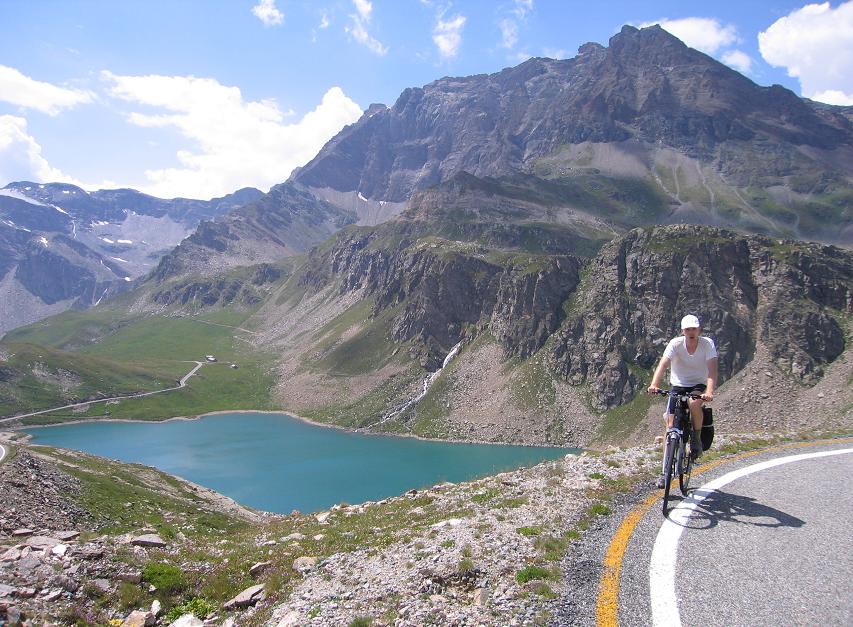
Location: Spain, Miodle of the Pyrenées or Pirineos; the ascent starts ca. 10kms south from the Vielha tunnel.
Introduction: Presa de l’Lauset is a artifical lake, used by a dam to hold the water. It is situated at the height level of 2197 m, not far from Aneto (3404 m), the highest peak of the Pyrenées. The road going to the dam is owned by the water plant company and wasn’t renovated, renewed for few decades so its quality is awful (in the year of 2010): there are lot of potholes and the road somewhere became dirt road. It reaches the level of the lake after going through a ca. 1 km long tunnel. Its bad quality is partly compensated by the wonderful landscape: grassy mountainsides, waterfall, rocks mountains and great views and the lake between the rocky mountains. The road’s average steepness is 6,8%.
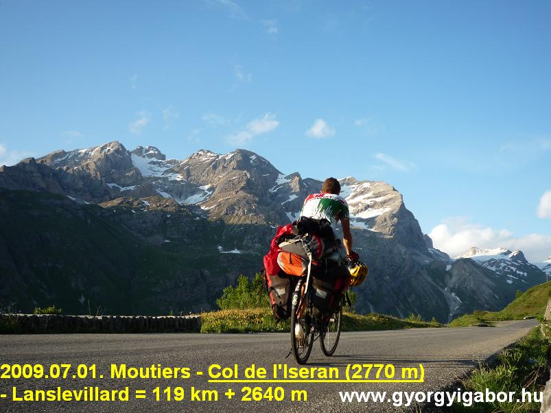
Location: France, Vanoise National Park, between Modane and Bourg St Maurice
Introduction: Col de l’Iseran is the highest paved pass of the Alps and one of my favourites and besides it is wonderful. It ascends and twists and turns upwards in the Vanoise National Park, between high, snowy peaks, somewhere glaciers on them. Above 1700 m the traffic is not too much so this is an other enjoyable mountain road. Coming from North the 1st half to Val d’Isere there are enough traffic. After reaching the lakest he landscape become more attractive and after leaving Val d’Isere we can feel the breath of the nature, enjoy beautiful snowy and wild mountains and the view to the lake from above. Cycling from South, Lanslevillard the flat section gives surprises by wonderful waterfalls and steep mountainwalls. The real slope starts at Bonneval sur Arc (1787 m): to the pass (2770 m) the road ascends 13,4kms, so te average steepness is 7,3%. Above ca. 2200 m the climb is wonderful.
Profiles: southern side from Bonneval: 13,4 km + 977 m, avg steepness: 7,3%-os and northern side 48 km + 1955 m heightdifference; without the flat sections it is 6% steep.
Location: France, Cote ’Azur Alps, Mercantour National park – ca. 120kms from Nice towards North
Introduction: Althout there isa sign that it is the highest paved road of Europe, truely it is nor Europe’s highest, nor the Alps highest paved ascent, but it is France’s highest finishing paved road. In the French Alps there are less motorbikers than in Italy and for fortune this region is visited by less bikers than for example the northern French Alps with Passo Gavia and Iseran – I think. Although it is a high pass, the road and the surrounding nature is very calm, silent. It’s true that Bonette is not so wonderful than Passo dello Stelvio, Col de l’Iseran or the Grossglockner road, but for me it is between the 10-12 most favourite ascents I’ve ever bicycled.
Coming from South, the serious slope begins at St Etienne de Tinee (1144 m), where from the cyclist has to climb more than 1600m heightdifference in 26 kms with an average steepness of 6-7%. From North, Jausiers village (1210 m) the distance is 28 km and the heightdifference is 1592 m.
Cycling from South in the undisturbed nature we can enjoy a great waterfall and pedalling closer to to the top sometimes marmottes can be seen and enjoyed. There is a true col, the Col de la Bonette at 2715 m, where from the less than last km is 12-15% steep. There is a choice to the highest paved point: ont he left or right side of the mountainpeak: I think the right side is little bit lighter and the left one is the steeper.
The height of this road is record only in France and not in the Alps, but for challenger cyclists a record can get, as I did it in the year 2008: starting from Nice (carrying 26 kg weighte panniers on my bicycle) this road, ascent offers the most heightdifference inside an „ascent”, if we consider this as a whole ascent from Nice to the 2812m high top. The distance is 120 kms.
Difficulty of the ascent: Not the steepness is truely the difficulty, but its length and the last steep km!
Introduction: Mangart road is Slovenia’s only one paved road going above 2000 m. The Julian Alps’ wild mountains, rockwalls remembers me to the Dolomites, this ascent remembers me to the Dolomites too. The ascent starts at the eastern side of the Predel pass (1150 m). and the cyclist has to ascend in 953 m heightdifference in 11,3 kms to reach the highest poitnt at 2055 m. That means 8,4% average steepness. Cycling the lower part of the ascent we can feel the breath of the plants, then we can enjoy the romantic tunnels through the wild rocks and at last the road goes along a very steep, vertical rockwall giving great view to the valley. The road’s maximum steepness is 16%.
Profile / steepness: profile by salite.ch : 11,3 km & 953 m heightdifference, avg. steepness: 8,4%
Location: Central Switzerland, next to Grindelwald, in front of Jungfrau peak (4158 m)
Introduction: In Switzerland there is a famous place with the legendary trio of high mountains around the heightlevel of 4000 m: Eiger (3970 m), Mönch (4099 m) and Jungfrau (4158 m). Männlichen, this viewpoint can be found just in front of the Mönch a pass at the height of 2229 m between the Lauterbrunen valley and Grindelwald. It can be reached by cablecar from Wengen (next to Lauterbrunnen) or by bicycle on paved road starting from Grindelwald. The road, which twists and turns in front of the Eiger’s huge and wild rockwall, is often 10% steep, but last 4 kms are 12-13% steep. The summit offers great views for the famous mountains and to the Lauterbrunnen valley.
Profile: profile by salite.ch : 13,6 km + 1349 m , avg. steepness: 9,9% ; last 10 kms are ca. 11% steep
Location: Central Switzerland, next to Grindelwald, opposite of Eiger peak (3970 m)
Introduction: The previous mentioned three famous peaks can be seen, viewed from Oberläger or its steep ascent. Cycling this hard climb the mountain-trio and Wetterhorn can be seen better but the three ones not so closer. Opposite of Männlichen, Oberläger doesn’t give other views. Like Männlichen this is another calm, undisturned mountain road, which is ca. as steep than the other, but its last km is steeper with its 14-16% steepness. There is almost no traffic in its last 2-3 kms, so it easy to see marmottes.
In the year of 2011 I sent its profile to salite.ch: profile : 10,7 km + 991 m heightdiff; avg steepness: 9,3%, but
Finishing the first part of the collection with that climb of my tour in the year 2011, where I reached the fact having cycled up to all of the – known - paved road going above 2000 m (based on ca. 15 ascents collecting lists) and could felt catharsis too.
Diga Finstertal (2350 m)
Location: Austria, Tirol; next to Kühtai
Introduction: Choosing this climb as being between the 20-25 most wonderful ones in the Alps is a subjective opinion, but the reason is not that I felt catharsis, unforgettable moment after reaching the top, but I had to note that I needed the perfect lights, weather situation to have such a wonderful afternoon. Turning South from Kühtai the cyclists needs to climb only 4 kms (10-12% steepness!) to the dam which 4 kms have few hairpin bends, great panorama, silence and at the top the lake with enjoying the pictures of the clouds in its watersurface.
SOK hiánya van, nem csak kuriózumok, így pl: Simplonpass, Moutiere, Col de Granon, Colle Esischie, Val Thorens, Alpe Galm, Alp Anarosa, Grosse Oscheniksee, stb...


 Legszebb emelkedők


")
")
")


")
")
")
")
")
")
 - Pireneusok")
 - Pireneusok")
")
")
